Lake Volta

Last updated
Lake Volta
Adomi-bridge 0418.png
view of Lake Volta and Adomi bridge
Ghana physical map.svg
Red pog.svg
Lake Volta
Volta river black white red descriptions.PNG
Lake Volta in Ghana
Location Ghana, West Africa
Coordinates 6°30′N0°0′E / 6.500°N 0.000°E / 6.500; 0.000
Lake type Reservoir
Primary inflows White Volta River
Black Volta River
Primary outflows Volta River
Catchment area 385,180 km2 (148,720 sq mi)
Basin  countriesGhana
Surface area 8,502 km2 (3,283 sq mi)
Average depth18.8 m (61 ft 8 in)
Max. depth75 m (246 ft)
Water volume 148 km3 (32.6 × 10¹² gallons)
Shore length14,800 kilometres (2,980 mi)
Surface elevation85 m (279 ft)
1 Shore length is not a well-defined measure.

Lake Volta, the largest artificial reservoir in the world based on surface area, is contained behind the Akosombo Dam which generates a substantial amount of Ghana's electricity. It is completely within the country of Ghana and has a surface area of 8,502 square kilometres (3,282+12 sq mi). [1] It extends from Akosombo in the south to the northern part of the country. [2] [3]

Contents

Geography

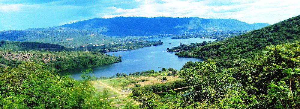
Lake Volta lies along the prime meridian, six degrees north of the Equator. The lake's northernmost point is close to the town of Yapei, and its southernmost extreme is at the Akosombo Dam, 520 km (320 mi) downstream from Yapei. Akosombo Dam holds back both the White Volta River and the Black Volta River, which formerly converged where the middle of the reservoir now lies, to form the single Volta River. The present Volta River flows from the outlets of the dam's powerhouse and spillways to the Atlantic Ocean in southern Ghana.

The main islands within the lake are Dodi, Dwarf, and Kporve. [4] Digya National Park lies on part of the lake's western shore.

History

The lake was formed by the Akosombo Dam, which was originally conceived by the geologist Albert Ernest Kitson during the British colonial period in 1915, to exploit the river's energy for smelting locally-sourced bauxite. The idea regained prominence at the end of the colonial era after the World War II when Kwame Nkrumah became president of the Gold Coast colony and began striving for modernization of the land. British and local governments formed a joint preparatory commission, which concluded that over 60.000 people will have to be relocated, but that the lake will boost opportunities for fishing, thus helping to feed the population in the region. On the other hand, issues with water-related illnesses were predicted, such as malaria, trypanosomiasis, schistosomiasis, and onchocerciasis. [5]

Fishing boats in one of the lakeshore communities Fishing community.jpg
Fishing boats in one of the lakeshore communities

Aluminium Limited, the main industrial sponsor of the project, withdrew after Ghana became independent in 1957. Revised plans dropped the idea of integrated aluminium industry and proposed smelting imported bauxite instead. Kaiser Aluminum entered the project at this point and after protracted negotiations, funding for the project was secured, but now without regard to residents of the impacted area as a cost-cutting measure. Construction thus began before the government started planning the resettlement. Soon after, a public agency was established, and organized construction of 52 replacement towns, which were envisioned to serve as a model for modernization and improving the livelihood of the local population. But because of the rush, the resettlement in 1964 turned out to be chaotic and inefficient. Poor organization caused the issues to continue long after the project's completion and caused significant hardship to the local population. [5] Together, 15,000 homes in 740 villages were flooded, necessitating resettlement of 78,000 people. [1]

In the long run, formation of the lake disrupted traditional fishing and farming practices in the region and caused a large spike in disease prevalence. Government-led modernization did not succeed, and people had to adapt to the new circumstances themselves. [5] Despite that, regional food production intensified in the decades after the construction of Akosombo dam, and the lake also opened a large navigable pathway to the north of the country and provided new opportunities for development of tourism which is gaining in prominence. On the other hand, water level has been decreasing recently because of global warming, reducing power generation. [6]

Economy

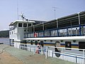
The Akosombo Dam produces 912 MW of electricity for the country, as well as for export to Togo, Benin, and other nearby countries to earn foreign exchange. [1] Lake Volta is also important for transportation, providing a waterway for both ferries and cargo watercraft. Since the huge lake lies in a tropical area, the water remains warm year-round naturally. Given good management, Lake Volta is the location of a vast population of fish and large fisheries.

The lake also attracts tourism, and tourist cruises visit the island of Dodi. [4]

Recent developments include a large-scale enterprise to harvest submerged timber from the flooded forests under Lake Volta. This project harvests high-value tropical hardwood without requiring additional logging or destruction of existing forest and, according to Wayne Dunn, "could generate the largest source of environmentally sustainable natural tropical hardwood in the world." [7] In addition to generating foreign currency for the region and reducing the dependence of locals on fishing as a primary economic activity, the removal of submerged trees is improving navigation on the lake and increasing safety. [7]

An estimated 7,000 to 10,000 children work in the fishing industry on Lake Volta. The nature of their employment has been described as slavery in The Guardian [8] and by the CNN Freedom Project. This has been described as sensationalism by Betty Mensah and the academic Samuel Okyere since many of the children and youth whose wages are given upfront to their parents grow up to become self-sufficient fishermen in adulthood who in turn hire children themselves and could therefore also be characterized as apprentices. They conclude that many children may suffer under exploitative work but are not enslaved. [9] [10]

Volta lake from the Saint Barbara Church.JPG
Panorama and landscape of Lake Volta in Ghana: Lake Volta is the largest reservoir by surface area in the world.

Photos

See also

Related Research Articles

<span class="mw-page-title-main">Geography of Ghana</span> West African country

Ghana is a West African country in Africa, along the Gulf of Guinea.

<span class="mw-page-title-main">Volta River</span> River in West Africa

The Volta River is the main river system in the West African country of Ghana. It flows south into Ghana from the Bobo-Dioulasso highlands of Burkina Faso. The main parts of the river are the Black Volta, the White Volta, and the Red Volta. In the northwest, the Black Volta forms the international borders between the Ivory Coast, Ghana, and Burkina Faso. The Volta flows southward along the Akwapim-Togoland highlands, and it empties into the Atlantic Ocean at the Gulf of Guinea at Ada Foah. It has a smaller tributary river, the Oti, which enters Ghana from Togo in the east. The Volta River has been dammed at Akosombo for the purpose of generating hydroelectricity. The reservoir named Lake Volta stretches from Akosombo Dam in the south to the northern part of the country, and is the largest man-made reservoir by area in the world.

<span class="mw-page-title-main">Lake Nasser</span> Reservoir in southern Egypt and northern Sudan

Lake Nasser is a vast reservoir in southern Egypt and northern Sudan. It is one of the largest man-made lakes in the world. Before construction, Sudan was against the building of Lake Nasser, because it would encroach on land in the northern part of the country, where many Nubian people lived who would have to be resettled. In the end Sudan's land near the area of Lake Nasser was mostly flooded by the lake.

<span class="mw-page-title-main">Akosombo Dam</span> Dam in Akosombo, Ghana

The Akosombo Dam, also known as the Volta Dam, is a hydroelectric dam on the Volta River in southeastern Ghana in the Akosombo gorge and part of the Volta River Authority. The construction of the dam flooded part of the Volta River Basin and led to the subsequent creation of Lake Volta. Lake Volta is the largest man-made lake in the world by surface area. It covers 8,502 square kilometres (3,283 sq mi), which is 3.6% of Ghana's land area. With a volume of 148 cubic kilometers, Lake Volta is the world's third largest man-made lake by volume; the largest being Lake Kariba which contains 185 cubic kilometers of water.

<span class="mw-page-title-main">Dale Hollow Reservoir</span> Reservoir in Tennessee and Kentucky, United States

The Dale Hollow Reservoir is a reservoir situated on the Kentucky/Tennessee border. The lake is formed by the damming of the Obey River, 7.3 miles (11.7 km) above its juncture with the Cumberland River at river mile 380. Portions of the lake also cover the Wolf River. Dale Hollow is one of four major flood control reservoirs for the Cumberland; the others being Percy Priest Lake, Lake Cumberland, and Center Hill Lake. It is also the site of Dale Hollow Lake State Park on the north (Kentucky) side.

<span class="mw-page-title-main">Eastern Region (Ghana)</span> Region of Ghana

The Eastern Region is located in the Eastern part of Ghana and is one of the sixteen administrative regions of Ghana. Eastern region is bordered to the east by the Lake Volta, to the north by Bono East Region and Ashanti region, to the west by Ashanti region, to the south by Central region and Greater Accra Region. Akans are the dominant inhabitants and natives of Eastern region and Akan, Ewe, Krobo, Hausa and English are the main spoken languages. The capital town of Eastern Region is Koforidua.The Eastern region is the location of the Akosombo dam and the economy of the Eastern region is dominated by its high-capacity electricity generation. Eastern region covers an area of 19,323 square kilometres, which is about 8.1% of Ghana's total landform.

<span class="mw-page-title-main">Asuogyaman District</span> District in Eastern Region, Ghana

Asuogyaman District is one of the thirty-three districts in Eastern Region, Ghana. Originally created as an ordinary district assembly in 1988, which it was created from the former Kaoga District Council. The district assembly is located in the eastern part of Eastern Region and has Atimpoku as its capital town.

<span class="mw-page-title-main">Brokopondo Reservoir</span> Reservoir in Suriname

The Brokopondo Reservoir, officially named Professor Doctor Ingenieur W. J. van Blommestein Meer, and also called the Brokopondostuwmeer, is a large reservoir in Suriname. It is named after the Surakarta-born Dutch hydrological engineer Willem Johan van Blommestein. With a surface area of approximately 1,560 km2 (600 sq mi), depending on the current water level, it is one of the largest reservoirs in the world, covering nearly one percent of the country.

Underwater logging is the process of logging trees from underwater forests. When artificial reservoirs and dams are built, large areas of forest are often inundated; although the trees die, the wood is often preserved. The trees can then be felled using special underwater machinery and floated up to the surface. One such machine is the sawfish harvester. There is an ongoing debate to determine whether or not underwater logging is a sustainable practice and if it is more environmentally sustainable than traditional logging.

The Volta River Authority (VRA) is the main generator and supplier of electricity in Ghana. They are also the responsible for the maintenance of the hydro power supply plant.

<span class="mw-page-title-main">Bui Dam</span> Dam in On the border of the Savannah Region and the Bono Region

The Bui Dam is a 400-megawatt (540,000 hp) hydroelectric project in Ghana. It is built on the Black Volta river at the Bui Gorge, at the southern end of Bui National Park. The project was a collaboration between the government of Ghana and Sino Hydro, a Chinese construction company. Construction on the main dam began in December 2009. Its first generator was commissioned on 3 May 2013, and the dam was inaugurated in December of the same year.

Industry in Ghana accounts for about 24.5% of total GDP. However, Ghana's industrial production is rising at a 7.8% rate, giving it the 38th fastest growing industrial production in the world due to government industrialization policies.

<span class="mw-page-title-main">Electricity sector in Ghana</span> Government of Ghana sponsored electricity supply

Ghana generates electric power from hydropower, fossil-fuel, and renewable energy sources such as wind and solar energy. Electricity generation is one of the key factors in order to achieve the development of the Ghanaian national economy, with aggressive and rapid industrialization; Ghana's national electric energy consumption was 265 kilowatt hours per each one in 2009.

The Nechako Reservoir, sometimes called the Ootsa Lake Reservoir, is a hydroelectric reservoir in British Columbia, Canada that was formed by the Kenney Dam making a diversion of the Nechako River through a 16-km intake tunnel in the Kitimat Ranges of the Coast Mountains to the 890 MW Kemano Generating Station at sea level at Kemano to service the then-new Alcan aluminum smelter at Kitimat. When it was constructed on the Nechako River in 1952, it resulted in the relocation of over 75 families. It was one of the biggest reservoirs built in Canada until the completion of the Columbia Treaty Dams and the W.A.C. Bennett Dam that created Lake Williston. The water level may swing 10 feet between 2790 and 2800 feet.

<span class="mw-page-title-main">Pardee Dam</span> Dam in Calaveras County, California

Pardee Dam is a 345-foot (105 m)-high structure across the Mokelumne River which marks the boundary between Amador and Calaveras Counties, located in the foothills of the Sierra Nevada approximately 30 miles (48 km) northeast of Stockton.

The Kpong Dam, also known as the Akuse Dam, is a hydroelectric power generating dam on the lower Volta River near Akuse in Ghana. It is owned and operated by Volta River Authority. It was constructed between 1977 and 1982. Its power station has a capacity of 148 megawatts (198,000 hp) with all four units running, though the total nameplate capacity is 160 megawatts (210,000 hp).

<span class="mw-page-title-main">Ada Foah</span> District Capital in Greater Accra Region, Ghana

Ada Foah is a town on the southeast coast of Ghana, where the Volta River meets the Atlantic Ocean. The town is located along the Volta River, off of the Accra-Aflao motorway. Known for palm-lined beaches and estuary islands, Ada Foah is also the capital of the Ada East District and the seat of the District Assembly.

<i>Dodi Princess</i> Former Ghanaian cruise boat

Dodi Princess was a cruise boat on Lake Volta in South Ghana. It was owned by the Volta River Authority and under the management of Volta Hotels. It was the only cruise ship in Ghana. It was built as a cargo ship and later converted into a passenger ship in 1991.

Volta Hotels Limited is Strategic Business Unit instituted by the Volta River Authority (VRA), in Ghana.

The Akosombo Dam Spillage Flood is a riverine flood that occurred in the south-eastern part of Ghana. This is due to a controlled spillage of the Akosombo Dam and the Kpong Dam by the Volta River Authority to address rising water levels.

References

  1. 1 2 3 "Lake Volta | lake, Ghana". Encyclopedia Britannica. Retrieved 2021-02-06.
  2. "Lake Volta, Ghana". Visible Earth. NASA. 7 April 2002. Retrieved 7 March 2018.
  3. "Largest, Tallest, Biggest, Shortest". McqsPoint. Archived from the original on 9 February 2019. Retrieved 9 February 2018.
  4. 1 2 "Dodi Island cruises". secureserver.net. Archived from the original on 2010-10-31.
  5. 1 2 3 Miescher, Stephan F. (2021-10-01). "Ghana's Akosombo Dam, Volta Lake Fisheries & Climate Change". Daedalus. 150 (4): 124–142. doi:10.1162/daed_a_01876.
  6. Gyau-Boakye, P. (2001). "Environmental impacts of the Akosombo Dam and effects of climate change on the lake levels". Environment, Development and Sustainability. 3 (1): 17–29. doi:10.1023/A:1011402116047.
  7. 1 2 "Harvesting an Underwater Forest". Archived from the original on March 4, 2012. Retrieved 28 May 2011.{{cite web}}: CS1 maint: unfit URL (link)
  8. "Sons for Sale". www.theguardian.com. 22 March 2007.
  9. Okyere, Samuel (18 March 2019). "How CNN reported on 'child slaves' who were not really enslaved". AlJazeera. Retrieved 30 July 2019.
  10. "Ghanaian children wrongly taken in raids backed by US charity IJM". BBC News. July 10, 2023.