
A nature reserve is a protected area of importance for flora, fauna, funga, or features of geological or other special interest, which is reserved and managed for purposes of conservation and to provide special opportunities for study or research. They may be designated by government institutions in some countries, or by private landowners, such as charities and research institutions. Nature reserves fall into different IUCN categories depending on the level of protection afforded by local laws. Normally it is more strictly protected than a nature park. Various jurisdictions may use other terminology, such as ecological protection area or private protected area in legislation and in official titles of the reserves.

Lake Kariba is the world's largest artificial lake and reservoir by volume. It lies 1,300 kilometres (810 mi) upstream from the mouth of the Zambezi river on the Indian Ocean, along the border between Zambia and Zimbabwe. Lake Kariba was filled between 1958 and 1963 following the completion of the Kariba Dam at its northeastern end, flooding the Kariba Gorge on the Zambezi River.

The Brong-Ahafo region was a region in central Ghana. Brong-Ahafo was bordered to the north by the Black Volta river and to the east by the Lake Volta, and to the south by the Ashanti, Eastern and Western regions. The capital of Brong-Ahafo is Sunyani. Brong-Ahafo was created on 14 April 1959 from the then Western Ashanti and named after the main ethnic groups, the Brong and Ahafo. In 2019, as a result of the 2018 Ghanaian new regions referendum, the region was divided into three, namely Bono, Bono East and Ahafo regions, and ceased to exist.

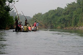
Lake Volta, the largest artificial reservoir in the world based on surface area, is contained behind the Akosombo Dam which generates a substantial amount of Ghana's electricity. It is completely within the country of Ghana and has a surface area of 8,502 square kilometres (3,283 sq mi). It extends from Akosombo in the south to the northern part of the country.

Kakum National Park, located in the coastal environs of the Central Region of Ghana, covers an area of 375 square kilometres (145 sq mi). Established in 1931 as a reserve, it was gazetted as a national park only in 1992 after an initial survey of avifauna was conducted. The area is covered with tropical forest. The uniqueness of this park lies in the fact that it was established at the initiative of the local people and not by the State Department of wildlife who are responsible for wildlife preservation in Ghana. It is one of only 3 locations in Africa with a canopy walkway, which is 350 metres (1,150 ft) long and connects seven tree tops which provides access to the forest.

Nagarahole National Park is a national park located in Kodagu district and Mysore district in Karnataka, India.

Bardiya National Park is a protected area in Nepal that was established in 1988 as Royal Bardia National Park. Covering an area of 968 km2 (374 sq mi) it is the largest and most undisturbed national park in Nepal's Terai, adjoining the eastern bank of the Karnali River and bisected by the Babai River in the Bardiya District. Its northern limits are demarcated by the crest of the Siwalik Hills. The Nepalgunj-Surkhet highway partly forms the southern boundary, but seriously disrupts the protected area. Natural boundaries for human settlements are formed in the west by the Geruwa, a branch of the Karnali River, and in the southeast by the Babai River. Together with the neighboring Banke National Park, the coherent protected area of 1,437 km2 (555 sq mi) represents the Tiger Conservation Unit (TCU) Bardia-Banke that extends over 2,231 km2 (861 sq mi) of alluvial grasslands and subtropical moist deciduous forests.

Burkina Faso is largely wild bush country with a mixture of grass and small trees in varying proportions. The savanna region is mainly grassland in the rainy season and semi desert during the harmattan period. Fauna, one of the most diverse in West Africa, includes the elephant, hippopotamus, buffalo, monkey, lions, crocodile, giraffe, various types of antelope, and a vast variety of bird and insect life. The country has 147 mammal species, 330 aquatic species including 121 species of fish and 2067 different plant species. Of the plant species, the dominant endemic species are shea tree and the baobab, the former plant species has immense economic value to the country.

The wildlife of Zimbabwe occurs foremost in remote or rugged terrain, in national parks and private wildlife ranches, in miombo woodlands and thorny acacia or kopje. The prominent wild fauna includes African buffalo, African bush elephant, black rhinoceros, southern giraffe, African leopard, lion, plains zebra, and several antelope species.

Nkhotakota Wildlife Reserve, is the largest and oldest wildlife reserve in Malawi, near Nkhotakota. The park's hilly terrain features dambos and miombo woodlands as the dominant vegetation, which support a variety of mammal and bird species. Poaching has greatly reduced the number of elephants and other large mammals in Nkhotakota, but conservation efforts to restore the elephant population started when African Parks began managing the reserve in 2015.

Gal Oya National Park in Sri Lanka was established in 1954 and serves as the main catchment area for Senanayake Samudraya, the largest reservoir in Sri Lanka. Senanayake Samudraya was built under the Gal Oya development project by damming the Gal Oya at Inginiyagala in 1950. An important feature of the Gal Oya National Park is its elephant herd that can be seen throughout the year. Three important herbs of the Ayurveda medicine, triphala: Terminalia chebula, Terminalia bellirica and Emblica officinalis are amongst the notable flora of the forest. From 1954 to 1965 the park was administrated by the Gal Oya Development Board until the Department of Wildlife Conservation took over administration. The national park is situated 314 km from Colombo.

Nouabalé-Ndoki National Park is a national park in the Republic of the Congo. Established in 1993, in the northern provinces of Congo, it is home to forest elephants, great apes, including western lowland gorillas and the eastern sub-species of chimpanzees and bongo. The forests have a rich biodiversity of 300 bird species, plus 1,000 plant and tree species which include endangered mahoganies.

Mole National Park, one of Ghana's seven national parks, is the country's largest wildlife refuge. The park is located in the Savannah region of Ghana on savanna and riparian ecosystems at an elevation of 50 m, with a sharp escarpment forming the southern boundary of the park. The Park is 24 km from Damongo, the district capital, 146 km south east of Tamale, the Regional capital. The park is 700 km from Accra and 430 km from Kumasi. The park's entrance is reached through the nearby town of Larabanga. It covers an area of about 4,577 square kilometers of fairly undisturbed Guinea savannah in the northern part of Ghana. The Levi and Mole Rivers are ephemeral rivers flowing through the park, leaving behind only drinking holes during the long dry season. This area of Ghana receives over 10 mm per year of rainfall. A long-term study has been done on Mole National Park to understand the impact of human hunters on the animals in the preserve.
The Bui National Park is located in Ghana. It was established in 1971. This park spans 1,821 km2.

Bwabwata National Park is a protected area in northeastern Namibia that was established in 2007 and covers 6,274 km2 (2,422 sq mi). It was created by merging Namibia's Caprivi Game Park and Mahango Game Park. It is situated in the Zambezi and Kavango East regions, extending along the Caprivi Strip. It is bounded by the Okavango River to the west and the Kwando River to the east. Angola lies to the north and Botswana to the south.
Tourism in Ghana is regulated by the Ministry of Tourism, Arts & Culture. This ministry is responsible for the development and promotion of tourism related activities in Ghana.
Kyabobo National Park is a 360 km2 (140 sq mi) national park in Ghana.

The Bono East region of Ghana is a new region carved out of the Brong Ahafo region. The capital of the new region is Techiman. This creation of this new region was in fulfillment of a promise made by the New Patriotic Party prior to the 2016 Ghana general election. Upon winning the elections, the President, Nana Akuffo Addo created the Ministry of Regional Reorganization to oversee policy formulation and implementation. In all six new regions are to be created from the existing ten regions of Ghana. The other regions are Ahafo, Western North, Savannah, North East, and Oti regions.

