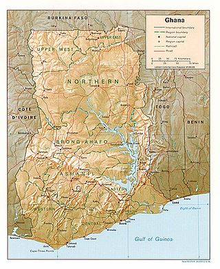
Ghana is a West African country in Africa, along the Gulf of Guinea.

The Volta River is the main river system in the West African country of Ghana. It flows south into Ghana from the Bobo-Dioulasso highlands of Burkina Faso. The main parts of the river are the Black Volta, the White Volta, and the Red Volta. In the northwest, the Black Volta forms the international borders between the Ivory Coast, Ghana, and Burkina Faso. The Volta flows southward along the Akwapim-Togoland highlands, and empties into the Atlantic Ocean at the Gulf of Guinea at Ada Foah. One of its smaller tributaries, the Oti River, enters Ghana from Togo in the east. The Volta River has been dammed at Akosombo for generating hydroelectricity. The reservoir named Lake Volta stretches from Akosombo Dam in the south to the northern part of the country, and is the largest man-made reservoir by area in the world.

The Akosombo Dam, also known as the Volta Dam, is a hydroelectric dam on the Volta River in southeastern Ghana in the Akosombo gorge and part of the Volta River Authority. The construction of the dam flooded part of the Volta River Basin and led to the subsequent creation of Lake Volta. Lake Volta is the largest man-made lake in the world by surface area. It covers 8,502 square kilometres (3,283 sq mi), which is 3.6% of Ghana's land area. With a volume of 148 cubic kilometers, Lake Volta is the world's third largest man-made lake by volume; the largest being Lake Kariba which contains 185 cubic kilometers of water.

The Black Volta or Mouhoun is a river that flows through Burkina Faso for approximately 1,352 km (840 mi) to the White Volta in Dagbon, Ghana, the upper end of Lake Volta. The source of the Black Volta is in the Cascades Region of Burkina Faso, close to Mount Tenakourou, the highest point of the country. Further downstream it forms part of the border between Ghana and Burkina Faso, and later between Côte d'Ivoire and Ghana. Within Ghana, it marks the border between the Savannah and Bono regions. The Bui Dam, a hydroelectric power plant, is built on the river, just south of the Bui National Park, which the river bisects.

The Brong-Ahafo region was a region in central Ghana. Brong-Ahafo was bordered to the north by the Black Volta river and to the east by the Lake Volta, and to the south by the Ashanti, Eastern and Western regions. The capital of Brong-Ahafo is Sunyani. Brong-Ahafo was created on 14 April 1959 from the then Western Ashanti and named after the main ethnic groups, the Brong and Ahafo. In 2019, as a result of the 2018 Ghanaian new regions referendum, the region was divided into three, namely Bono, Bono East and Ahafo regions, and ceased to exist.

Lake Volta, the largest artificial reservoir in the world based on surface area, is contained behind the Akosombo Dam which generates a substantial amount of Ghana's electricity. It is completely within the country of Ghana and has a surface area of 8,502 square kilometres. It extends from Akosombo in the south to the northern part of the country.

The Upper West Region of Ghana is located in the north-western corner of Ghana and is bordered by Upper East Region to the east, Northern Region to the south, and Burkina Faso to the west and north. The Upper West regional capital and largest settlement is Wa. The Upper West was created by the then Head of State, Flight-Lieutenant Jerry Rawlings in 1983 under the Provisional National Defence Council (PNDC) military regime. The area was carved out of the former Upper Region, which is now the Upper East Region. For about thirty-five years, it remained the youngest region of Ghana until 2018 when six more regions were created by the Nana Addo Dankwa Akufo-Addo government; hence increasing the total number of administrative regions in the country to sixteen.

The Eastern Region is located in the Eastern part of Ghana and is one of the sixteen administrative regions of Ghana. Eastern region is bordered to the east by the Lake Volta, to the north by Bono East Region and Ashanti region, to the west by Ashanti region, to the south by Central region and Greater Accra Region. Akans are the dominant inhabitants and natives of Eastern region and Akan, Ewe, Krobo, Hausa and English are the main spoken languages. The capital town of Eastern Region is Koforidua.The Eastern region is the location of the Akosombo dam and the economy of the Eastern region is dominated by its high-capacity electricity generation. Eastern region covers an area of 19,323 square kilometres, which is about 8.1% of Ghana's total landform.

The Northern Region is one of the sixteen regions of Ghana. It is situated in the northern part of the country and ranks as the second largest of the sixteen regions. Before its division, it covered an area of 25,000 square kilometres, representing 10 percent of Ghana's area. In December 2018, the Savannah Region and North East Region were created from it. The Northern Region is divided into 16 districts. The region's capital is Tamale, Ghana's third largest city.

Volta Region is one of Ghana's sixteen administrative regions, with Ho designated as its capital. It is located west of Republic of Togo and to the east of Lake Volta. Divided into 25 administrative districts, the region is multi-ethnic and multilingual, including groups such as the Ewe, the Guan, and the Akan peoples. The Guan peoples include the Lolobi, Likpe, Akpafu, Buem,Nyangbo,Avatime, and Nkonya. This region was carved out of the Volta Region in December 2018 by the New Patriotic Party. The people of the Volta Region are popularly known as Ewes. The people of the Volta Region are popular known for their rich cultural display and music some of which include Agbadza, Borborbor and Zigi.

Central Gonja District is one of the seven districts in Savannah Region, Ghana. The Black Volta forms the southern boundary of Central Gonja with Kintampo North District, and the White Volta flows north to south splitting the district in two. Originally it was formerly part of the then-larger West Gonja District on 23 December 1988, until the part of the district was split off by a decree of president John Agyekum Kufuor in August 2004 to create Central Gonja District; thus the remaining part has been retained as West Gonja Municipal District. The district assembly is located in the central part of Savannah Region and has Buipe as its capital town.

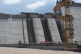
The Bui Dam is a 400-megawatt (540,000 hp) hydroelectric project in Ghana. It is built on the Black Volta river at the Bui Gorge, at the southern end of Bui National Park. The project was a collaboration between the government of Ghana and Sino Hydro, a Chinese state-owned construction company. Construction on the main dam began in December 2009. Its first generator was commissioned on 3 May 2013, and the dam was inaugurated in December of the same year.
Bia National Park is a national park in the Bia district in the Western Region of Ghana. It is also a biosphere reserve with a 563 square kilometer resource reserve. It has some of Ghana's last remnants of relatively untouched forest complete with its full diversity of wildlife. Some of the tallest trees left in West Africa are found in this national park. It constitutes a twin conservation area called the Bia National Park and the Bia Resource Reserve.

Kintampo waterfalls is one of Ghana' highest waterfalls located in Bono East. It was formerly known as Sanders Falls during the colonial days. It is located on the Pumpum river, a tributary of the Black Volta, about 4 kilometres (2.5 mi) north of the Kintampo municipality, on the Kumasi–Tamale road. It is just after the Falls Rest Stop when moving Northwards, on the right side of the road. This waterfall is hidden in the forest and formed by three main drops, with the longest measuring 25 metres (82 ft), followed by a number of steps and cascades, and the river, which falls about 70 metres (230 ft).

The Savannah Region is one of the newest regions of Ghana and yet the largest region in the country. The creation of the Region follows presentation of a petition by the Gonja Traditional Council, led by the Yagbonwura Tumtumba Boresa Jakpa I. Upon receiving favourable responses from all stakeholders in the Northern Region, the Brobbey Commission, a referendum was conducted on the 27th December 2018. The result was a resounding yes of 99.7%. The President of the Republic of Ghana signed and presented the Constitutional Instrument (CI) 115 to the Yagbonwura in the Jubilee House, Accra on 12 February 2019. The launch was well attended by sons and daughters of Gonjaland including all current and past Mps, MDCEs and all appointees with Gonjaland descent. Damongo was declared the capital of the new Savannah Region. It is located in the north of the country. The Savannah Region is divided into 7 districts; Bole, Central Gonja, North Gonja, East Gonja, Sawla/Tuna/Kalba, West Gonja, North East Gonja and 7 Constituencies; Bole/Bamboi, Damongo, Daboya/Mankarigu, Salaga North, Salaga South, Sawla/Tuna/Kalba and Yapei/Kusawgu. The capital of Bole district is Bole; East Gonja municipal is Salaga; West Gonja district is Damango; Sawla Tuna Kalba district is Salwa; Central Gonja is Buipe; North Gonja is Daboya; and North East Gonja is Kpalbe

The Bono region is one of the 16 administrative regions of Ghana. It is as a result of the remainder of Brong-Ahafo region when Bono East region and Ahafo region were created. Sunyani, also known as the green city of Ghana, is the regional capital. Sunyani can pride itself as the cleanest capital city and a major conference destination.

The Ghana–Ivory Coast border is 720 km in length and runs from the tripoint with Burkina Faso in the north to the Atlantic Ocean in the south.

The Bono East region of Ghana is a new region carved out of the Brong Ahafo region. The capital of the new region is Techiman. This creation of this new region was in fulfillment of a promise made by the New Patriotic Party prior to the 2016 Ghana general election. Upon winning the elections, the President, Nana Akuffo Addo created the Ministry of Regional Reorganization to oversee policy formulation and implementation. In all six new regions are to be created from the existing ten regions of Ghana. The other regions are Bono, Western North, Ahafo, Savannah, North East, and Oti regions.
The N12 or National Highway 12 is a national highway in Ghana that begins at the Ghana - Côte d'Ivoire border in the Western Region of Ghana and travels generally north to Hamile on the Ghana - Burkina Faso border. Its total length is 670 kilometres.


