The Eastern Region is located in the Eastern part of Ghana and is one of the sixteen administrative regions of Ghana. Eastern region is bordered to the east by the Lake Volta, to the north by Bono East Region and Ashanti region, to the west by Ashanti region, to the south by Central region and Greater Accra Region. Akans are the dominant inhabitants and natives of Eastern region and Akan, Ewe, Krobo, Hausa and English are the main spoken languages. The capital town of Eastern Region is Koforidua.The Eastern region is the location of the Akosombo dam and the economy of the Eastern region is dominated by its high-capacity electricity generation. Eastern region covers an area of 19,323 square kilometres, which is about 8.1% of Ghana's total landform.

Koforidua, also popularly known as K-dua or Koftown and now Kofcity, is a city and the capital of Eastern Region of Ghana. The city has a population of 183,727 people as of 2010. The city is a blend of colonial and modern architecture.
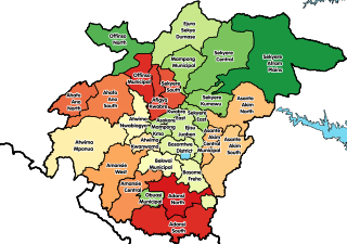
Sekyere East District is one of the forty-three districts in Ashanti Region, Ghana. Originally created as an ordinary district assembly in 1988, which was created from the former Sekyere District Council. Later, the eastern part of the district was split off to create the 1st Sekyere Afram Plains District on 1 November 2007, with Kumawu as its capital town. However, on 28 June 2012, the Afram Plains area of the district was split off to create the new Sekyere Afram Plains District, with Dobrosno as its capital town; while the remaining part has since then been officially renamed as Sekyere Kumawu District, with Kumawu as its capital town. The district assembly is located in the eastern part of Ashanti Region and has Effiduase as its capital town.
Asokore Mampong is the capital of the Asokore Mampong Municipal Assembly, a district in the Ashanti Region of Ghana. Popularly known for Kumasi Academy a senior high school and the SSNIT affordable housing projects. The chief of Asokore Mampong is Nana Boakye-Ansah Debrah.
Akrofuom is a town on Gyimi River in the Ashanti Region of Ghana. It is the capital of the Akrofuom District. The town is known for the Akrofuom Senior High Technical School. The school is a second cycle institution.
Fomena is a small town and the capital of the Adansi North District. The town is the seat of the paramount cheif of the Adansi traditional council. The town is known as the place where the Fomena treaty was signed.
Jamasi is a town in the Ashanti Region of Ghana.
Districts of Ghana Sekyere South
Asaman is a village in the Afigya Sekyere District of Ashanti. The village is known for the Konadu Yiadom Secondary School. The school is a second cycle institution.

Wiamoase is a town in the Sekyere South district, a district in the Ashanti Region of Ghana.
Jacobu is the capital town of Amansie Central, a district in the Ashanti Region of Ghana. It is near Bekwai. Jacobu and its neighbouring towns form the Odotobri paramountcy.
Akumadan is the capital of Offinso North, a district in the Ashanti Region of Ghana. It has a population of about 20000. Akumadan township is well known for its agricultural activities. All sorts of food crops can be planted on its soil but tomatoes is the largest crop. 90 percent of natives above 18 years are tomato farmers. They produce more tomatoes than any other town in Ghana. It has a dam that helps to irrigate some farmlands within its reach during dry seasons. Cassava, pepper, onion, garden eggs, plantain, maize etc. are also abundant. A company called Fomghana has acquired a large area of land for planting trees near a river that irrigates it. Recently, the President Nana Addo Dankwa Akuffo-Addo formally opened a Greenhouse project. Its poised to train young people in Agric Technology.
Asokore is a town in the Ashanti Region of Ghana. The town is known for T.I. Ahmadiyya Girls Senior High School, Krobea-Asante Senior High, Tijjania Senior High school and Nasir Children Training Centre one of the oldest Basic International School in the District established in 1984. These schools are second cycle institutions. Asokore is located in the Sekyere East district of Ashanti Region. It is second biggest town in the district and its capital town is Effiduase in the Ashanti region. Asokore is located 40 kilometers from Kumasi, the capital of Ashanti Region. Asokore is the headquarters of Asokore Rural Bank which has many branches in Kumasi and surrounding towns.
Kumawu is a small town and is the capital of Sekyere Kumawu, a district in the Ashanti Region of Ghana. The town is known for the Tweneboa Kodua Secondary School. The school is a second cycle institution.
Juaben is a small town in the Ejisu-Juaben Municipal District, a district in the Ashanti Region of Ghana.
Wamfie is a town located in the Bono Region of Ghana. It is the capital of Dormaa East District. The town is known for the Mansen Commercial Day Senior High School. The school is a second cycle institution. It is located at an elevation of 289 meters above sea level and its population amounts to 41,345. Its coordinates are 7°18'0" N and 2°42'0" W.
Adu Gyamfi Senior High School is a public senior high school located at Jamasi in the Sekyere East District of the Ashanti Region of Ghana.
T.I. Ahmadiyya Girls' Senior High School is a girls' second-cycle institution in Asokore in the Sekyere East District of Ashanti Region, Ghana.
Sekyere Kumawu District is one of the forty-three districts in Ashanti Region, Ghana. Originally it was part of the then-larger Sekyere East District, which was created from the former Sekyere District Council. Later, a large portion of the district was split off to create the 1st Sekyere Afram Plains District on 1 November 2007, with Kumawu as its capital town. However on 28 June 2012, the Afram Plains area of the district was split off to create the new Sekyere Afram Plains District, with Dobrosno as its capital town; while the remaining part has since then been officially renamed as Sekyere Kumawu District, with Kumawu as its capital town. The district assembly is located in the eastern part of Ashanti Region and has Kumawu as its capital town.
Krobea Asante Technical and Vocational School is a second-cycle institution in Effiduase Asokore in the Sekyere East District in the Ashanti Region of Ghana. The school is located on the outskirt of Asokore off Ahensan Road. The school is run by the Technical and Vocational Education and Training (TVET) Service in Ghana. In 2015, the school won the Member of Parliament's Independence Cup and was also the second Best Technical Institute in the Ashanti Region.
Simms Senior High School (SIMMSCO) is a co-ed secondary school located in Fawoade in the Ashanti Region established in 1977 as a private school by Mr. Simms Kofi Mensah to provide education to the people of Kwabre in the Ashanti Region.