
The Brong-Ahafo region was a region in southern Ghana. Brong-Ahafo was bordered to the north by the Black Volta river and to the east by the Lake Volta, and to the south by the Ashanti, Eastern and Western regions. The capital of Brong-Ahafo is Sunyani. Brong-Ahafo was created on 14 April 1959 from the then Western Ashanti and named after the dominant and native inhabitants, Akans, Brong and Ahafo. In 2019, as a result of the 2018 Ghanaian new regions referendum, the region was divided into three, namely Bono, Bono East and Ahafo regions, and ceased to exist.

The Ashanti Region is located in southern part of Ghana and it is the third largest of 16 administrative regions, occupying a total land surface of 24,389 km2 (9,417 sq mi) or 10.2 percent of the total land area of Ghana. In terms of population, however, it is the most populated region with a population of 4,780,380 according to the 2011 census, accounting for 19.4% of Ghana's total population. The Ashanti Region is known for its major gold bar and cocoa production. The largest city and regional capital is Kumasi.
Sekyere South District is one of the forty-three districts in Ashanti Region, Ghana. Originally created as an ordinary district assembly in 1988 when it was known as Afigya-Sekyere District, which it was created from part of the former Kwabre-Sekyere District Council; until the western part of the district was split off to become the northern portion of Afigya-Kwabre District on 1 November 2007 ; while the remaining portion has since then been officially renamed as Sekyere South District. The district assembly is located in the eastern part of Ashanti Region and has Agona as its capital town.
Asamankese is a town in south Ghana and is the capital of West Akim Municipal District, a district in the Eastern Region of south Ghana. Asamankese has a 2013 settlement population of approximately 39,435 people. Asamankese is on the main highway to Kumasi and Accra in the interior.

Theni is a town and a municipality in Theni district in the Indian state of Tamil Nadu. As of 2011, the town had a population of 94,453. The metro area had the population of 202,100.
Agogo is a town in the Asante Akim North Municipal District of the Ashanti Region of Ghana. Agogo is approximately 80 kilometers east of Kumasi, the capital of the Ashanti Region, and had a population of 28,271 in the 2000 census. Computer projections estimate that the 2007 population was 32,859.
Asokore Mampong is the capital of the Asokore Mampong Municipal Assembly, a district in the Ashanti Region of Ghana. Popularly known for Kumasi Academy a senior high school and the SSNIT affordable housing projects. The chief of Asokore Mampong is Nana Boakye-Ansah Debrah.
Jamasi is a town in the Ashanti Region of Ghana.
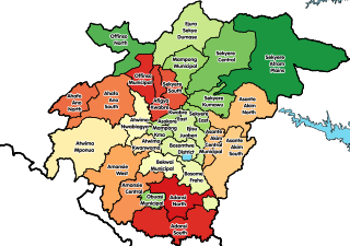
Districts of Ghana Sekyere South
Asaman is a village in the Afigya Sekyere District of Ashanti. The village is known for the Konadu Yiadom Secondary School. The school is a second cycle institution.

Wiamoase is a town in the Sekyere South district, a district in the Ashanti Region of Ghana.
Akumadan is the capital of Offinso North, a district in the Ashanti Region of Ghana. It has a population of about 20000. Akumadan township is well known for its agricultural activities. All sorts of food crops can be planted on its soil but tomatoes is the largest crop. 90 percent of natives above 18 years are tomato farmers. They produce more tomatoes than any other town in Ghana. It has a dam that helps to irrigate some farmlands within its reach during dry seasons. Cassava, pepper, onion, garden eggs, plantain, maize etc. are also abundant. A company called Fomghana has acquired a large area of land for planting trees near a river that irrigates it. Recently, the President Nana Addo Dankwa Akuffo-Addo formally opened a Greenhouse project. Its poised to train young people in Agric Technology.
Asokore is a town in the Ashanti Region of Ghana. The town is known for T.I. Ahmadiyya Girls Senior High School, Krobea-Asante Senior High and Tijjania Senior High school. These schools are second cycle institutions. Asokore is located in the Sekyere East district of Ashanti Region. It is second biggest town in the district and its capital town is Effiduase in the Ashanti region. Asokore is located 40 kilometers from Kumasi, the capital of Ashanti Region. Asokore is the headquarters of Asokore Rural Bank which has many branches in Kumasi and surrounding towns.
Effiduase is a town and is the capital of Sekyere East, a district in the Ashanti Region of Ghana. The Effiduase is known for the Effiduase Secondary Commercial School now Effiduase Senior High School and effiduasi senior high technical school. The Effiduase Secondary Commercial School is a second cycle institution. The Effiduase chief is Nana Adu Ameyaw II, Chief of the Ashanti sub-traditional council. Effiduase is made up of mostly traders. Effiduase is the district capital of Skyere East District. Effiduase houses the biggest hospital in its Sekyere East district.
Agona-Akrofoso, sometimes called Akrofonso, is a town in the Sekyere South District in the Ashanti Region of Ghana, approximately 38 kilometres (24 mi) north-east of the Ashanti Regional capital, Kumasi, and about two miles east of Agona, the district capital.
Zabzugu is a small town and is the capital of Zabzugu district, a district in the Northern Region of north Ghana. It has a nucleated settlement and less populated. Most of the people there are farmers and their main produce is Yam.

The Ashanti economy refers to the economy of Ashanti Region in southern Ghana. It is largely self-sufficient, being driven by its service sector as well as by natural resources, being one of the world's top 10 largest gold-producers, and the second largest cocoa producer. The Ashanti region is also known for its production of manganese, bauxite and agricultural commodities such as cocoa and yam, with the region having low levels of taxation and without much need for foreign direct investment. The Ashanti region's industrial sector is characterised primarily by aerospace with automotive manufacturing and repair of motor vehicles and motorcycles (25.2%), manufacturing (10.5%), other service activities (6.3%) and accommodation and food service activities (6.0%). The Ashanti region spans an area of 24,389 km2, and according to the 2000 census, the region had a population of 3,612,950, most of whom (94.2%) were ethnic Akans, of whom 82.9% were ethnic Ashanti. The capital of the region is Kumasi, which with a population of 2,069,350 as of 2013 represents a high level of urbanisation within the state.
Bomfobiri Wildlife Sanctuary is a bird sanctuary, located about 80 km northeast of Kumasi within a geographical coordinate of 06°54.595'N and 001°17.340'W. The 53 km2 Bomfobiri Wildlife Sanctuary was created in 1975 with a four distinct vegetative types such as Riverine Forest, Rainforest, Woodland Savannah and Grassland Savannah. Animals present on the reserve include several species of birds, crocodiles, baboons, Mona monkeys, buffalos, red river hogs, Maxwell's duiker, red flank duiker, Bushbuck and monitor lizards. The reserve has many forms of attraction point including the Lion Stone, Stone Bridge, Bomfobiri waterfall, Wala waterfall, and caves. Activities that can be engaged in includes hiking, mountain climbing, game viewing, bird watching, camping and swimming. The reserve takes the crocodile as its symbol.
Sekyere Kumawu District is one of the forty-three districts in Ashanti Region, Ghana. Originally it was part of the then-larger Sekyere East District, which was created from the former Sekyere District Council. Later, a large portion of the district was split off to create the 1st Sekyere Afram Plains District on 1 November 2007, with Kumawu as its capital town. However on 28 June 2012, the Afram Plains area of the district was split off to create the new Sekyere Afram Plains District, with Dobrosno as its capital town; while the remaining part has since then been officially renamed as Sekyere Kumawu District, with Kumawu as its capital town. The district assembly is located in the eastern part of Ashanti Region and has Kumawu as its capital town.

Philip Atta Basoah is a Ghanaian politician and member of the Seventh Parliament of the Fourth Republic of Ghana representing the Kumawu Constituency in the Ashanti Region on the ticket of the New Patriotic Party.
The Papa Nantwi festival is an annual festival celebrated by the people of Kumawu in the Sekyere East district in the Ashanti Region of Ghana, in the month of March every year. It is a cultural festival commemorated by all Ashantis though the cultural events take place at Kumawu. The festival is used in commemorating the bravery and self-sacrificial spirit of their great ancestor, Nana Tweneboa Kodua (I) who is purported to have offered his life to be sacrificed to assist the Ashantis in defeating the Gyamans who were their criminal overloads.


