
Guineafowl are birds of the family Numididae in the order Galliformes. They are endemic to Africa and rank among the oldest of the gallinaceous birds. Phylogenetically, they branched off from the core Galliformes after the Cracidae and before the Odontophoridae. An Eocene fossil lineage Telecrex has been associated with guineafowl; Telecrex inhabited Mongolia, and may have given rise to the oldest of the true phasianids, such as blood pheasants and eared pheasants, which evolved into high-altitude, montane-adapted species with the rise of the Tibetan Plateau. While modern guineafowl species are endemic to Africa, the helmeted guineafowl has been introduced as a domesticated bird widely elsewhere.
The helmeted guineafowl is the best known of the guineafowl bird family, Numididae, and the only member of the genus Numida. It is native to Africa, mainly south of the Sahara, and has been widely introduced, as a domesticated species, into the West Indies, North America, Brazil, Australia and Europe.
The Upper East Region is located in north Ghana and is the third smallest of the 16 administrative regions in Ghana. It occupies a total land surface of 8,842 square kilometers or 2.7 per cent of the total land area of Ghana. The Upper East regional capital is Bolgatanga, sometimes referred to as Bolga. Other major towns in the region include Navrongo, Paga, Bawku and Zebilla.
Kusasi is a Gur language spoken primarily in northern Ghana, and Burkina Faso. It is spoken by about 120,000 people and takes its name from the Kusasi people. Kusaal is closely related to Mampruli, the language of the Mamprussi, who live to the south, and to Dagbani. There is a major dialect division between Agole, to the east of the Volta river, and Toende, to the West. Agole has more speakers. The 6 district capital; Bawku West with Zebilla as capital and the rest; Binduri, Bawku, Tempane, Garu and Pusiga districts mostly Agole dialect speakers. The complete Bible translation is in the Agole dialect.

Bawku is a town and is the capital of the Bawku Municipal District, district in the Upper East region of north Ghana, adjacent to the border with Burkina Faso. Bawku has a 2012 settlement population of 69,527 people.
Binaba is a rural village in the Bawku West District of the Upper East Region in north Ghana. The village is 15 km south of the district capital Zebilla.

Bawku Municipal District is one of the fifteen districts in Upper East Region, Ghana. Originally created as an ordinary district assembly in 1988 when it was known as Bawku East District; which was established by Legislative Instrument (L.I.) 1439, until the southern part of the district was split off by a decree of president John Agyekum Kufuor in August 2004 to create Garu-Tempane District; thus the remaining part was elevated to municipal district assembly status on the same year to become Bawku Municipal District. However, on 28 June 2012, two parts of the district were later split off to create Binduri District and Pusiga District respectively; thus the remaining part has been retained as Bawku Municipal District. The municipality is located in the eastern part of Upper East Region and has Bawku as its capital town.
Bawku West District is one of the fifteen districts in Upper East Region, Ghana. Originally created as an ordinary district assembly in 1988; which was established by Legislative Instrument (L.I.) 1442. The municipality is located in the eastern part of Upper East Region and has Zebilla as its capital town.
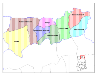
Talensi-Nabdam District is a former district that was located in Upper East Region, Ghana. Originally it was formerly part of the then-larger Bolgatanga District in August 2004. However, on 28 June 2012, it was split oft into two new districts: Talensi District and Nabdam District. The district assembly was located in the central part of Upper East Region and had Tongo as its capital town.
Kargów is a village in the administrative district of Gmina Tuczępy, within Busko County, Świętokrzyskie Voivodeship, in south-central Poland. It lies approximately 6 kilometres (4 mi) west of Tuczępy, 16 km (10 mi) east of Busko-Zdrój, and 46 km (29 mi) south-east of the regional capital Kielce.
Gałęzinowo is a village in the administrative district of Gmina Słupsk, within Słupsk County, Pomeranian Voivodeship, in northern Poland.
Wielichowo is a village in the administrative district of Gmina Słupsk, within Słupsk County, Pomeranian Voivodeship, in northern Poland. It lies approximately 10 kilometres (6 mi) north-west of Słupsk and 113 km (70 mi) west of the regional capital Gdańsk.
Sasek Wielki is a village in the administrative district of Gmina Szczytno, within Szczytno County, Warmian-Masurian Voivodeship, in northern Poland. It lies approximately 7 kilometres (4 mi) south-west of Szczytno and 41 km (25 mi) south-east of the regional capital Olsztyn.

Zebilla is one of the constituencies represented in the Parliament of Ghana. It elects one Member of Parliament (MP) by the first past the post system of election. Zebilla is located in the Bawku West district of the Upper East Region of Ghana.
Binduri is one of the constituencies represented in the Parliament of Ghana. It elects one Member of Parliament (MP) by the first past the post system of election. Binduri was part of in the Bawku Municipal district of the Upper East Region of Ghana but has since June 2012 become a full district.
Zongoiri Natinga is a community in the Bawku West District of the Upper East Region of Ghana, to the northwest of a bend in the White Volta River.
Kumawu is a small town and is the capital of Sekyere Kumawu, a district in the Ashanti Region of Ghana. The town is known for the Tweneboa Kodua Secondary School. The school is a second cycle institution.
Binduri District is one of the fifteen districts in Upper East Region, Ghana. Originally it was formerly part of the then-larger Bawku Municipal District in 1988; until two parts of the district were later split off to create Binduri District and Pusiga District respectively on 28 June 2012. The district assembly is located in the eastern part of Upper East Region and has Binduri as its capital town.
Pusiga District is one of the fifteen districts in Upper East Region, Ghana. Originally it was formerly part of the then-larger Bawku Municipal District in 1988; until two parts of the district were later split off to create Binduri District and Pusiga District respectively on 28 June 2012. The district assembly is located in the eastern part of Upper East Region and has Pusiga as its capital town.
The N11 or National Highway 11 is a national highway in Ghana that begins at Bolgatanga in the Upper East Region (N10) and runs east to Bawku, where it intersects with the N2. The N11 is 110.8 km long.


