Upper East Region

Last updated
Upper East Region, Dagbon
Rocks in the Tongo Hills, Gorogo, Upper East Region, Ghana.JPG
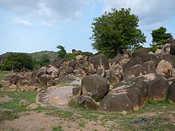
Rock formation in the Tongo Hills near Gorogo
Ghana-UpperEastRegion.png
Location of Upper East Region in Ghana
Country Ghana
Capital Bolgatanga
Districts10
Government
   Regional Minister Paulina Patience Abagaye [1]
Area
[2]
  Total8,842 km2 (3,414 sq mi)
  Rank Ranked 9th
Population
 (2021 Census) [3]
  Total1,301,226
  Rank Ranked 9th
  Density150/km2 (380/sq mi)
GDP (PPP)
  Year2013
  Per capita$5,150
GDP (Nominal)
  Year2013
  Per capita$2,500
Time zone GMT
Area code 039
ISO 3166 code GH-UE
HDI (2017)0.520 [4]
low · 8th

The Upper East Region is located in northern Ghana [5] and is the third smallest of the 16 administrative regions in Ghana. It occupies a total land surface of 8,842 square kilometers or 2.7 per cent of the total land area of Ghana. The Upper East regional capital is Bolgatanga, sometimes referred to as Bolga. Other major towns in the region include Navrongo, Paga, Sandema, Bawku, and Zebilla.

Contents

Geography

Location and size

The Upper East Region is located in the north-eastern corner of Ghana and bordered by Burkina Faso to the north and Togo to the east. It lies between longitude 0° and 1° West, and latitudes 10° 30′N and 11°N. The region shares boundaries with Burkina Faso to the north, Togo to the east, Upper West Region to the west, and the Northern Region to the south. The Upper East Region is divided into 15 districts, each headed by a district chief executive.

Tourism

Recreation areas

Historic sites

Festivals

The region plays host to many festivals throughout the year, most of which are either to bring a good planting season or celebrate the harvest.

Other tourist attractions

Demographics

Population

The center of population of the Upper East Region is located in its capital of Bolgatanga.

The population is primarily rural (79%) and scattered in dispersed settlements. The rural population was 87.1 percent in 1984 and 84.3% in 2000. There was, thus, a 2.8 percentage point reduction in the rural share of the population between 1984 and 2000 and a further 5.3 percent reduction between 2000 and 2010. [3]

With only 21 per cent of the population living in urban areas, the region is the least urbanized in Ghana. In fact, together with Upper West, they are the two regions with a less than 20 per cent urban population.

Ghanaian citizen by birth, childhood or parenthood constitute 92.5 percent of the population of the Upper East region. Naturalized Ghanaian citizen constitute 5.3 percent.

Upper East Region has a total population of 1,301,221 in the 2021 Population and Housing Census (PHC) conducted by the Ghana Statistical Service indicate that the Upper East Region representing 4.2 percent of Ghana’s population.

The region shows a total of 631,963 males and 669,963 representing 48.5 and 51.5 percentages respectively [7]

Transportation

Three national highwaysN2, N10, and N11 – and a few Regional highways such as the R113, R114, R116 and R181, serve the region.

The N10 originates from Yemoransa in the Central Region and connects through Kumasi in the Ashanti Region and terminates at Paga in the Upper East Region. The national capital of Accra is also connected to the region by the N2 which terminates in Kulungugu in the Upper East Region. Both these national routes are connected by the N11 which links the regional capital of Bolgatanga to Bimpiela, also in the region.

Administrative divisions

The political administration of the region is through the local government system. Under this administration system, the region is divided into 15 MMDA's (made up of 0 Metropolitan, 4 Municipal and 11 Ordinary Assemblies). [8] Each District, Municipal or Metropolitan Assembly, is administered by a Chief Executive, who represents the central government but deriving authority from an Assembly headed by a presiding member elected from among the members themselves. The current list is as follows:

Old Map of the Districts of the Upper East Region (2016) Districts of the Upper East Region (2012).svg
Old Map of the Districts of the Upper East Region (2016)
Districts of the Upper East Region [9]
#MMDA NameCapitalMMDA TypePopulation
1 Bawku Bawku Municipal
2 Bawku West Zebilla Ordinary
3 Binduri Binduri [10] Ordinary
4 Bolgatanga Bolgatanga Municipal
5 Bolgatanga East Zuarungu Ordinary
6 Bongo Bongo Ordinary
7 Builsa North Sandema Municipal
8 Builsa South Fumbisi [11] Ordinary
9 Garu Garu Ordinary
10 Kassena Nankana East Navrongo Municipal
11 Kassena-Nankana West Paga Ordinary
12 Nabdam Nangodi Ordinary
13 Pusiga Pusiga [12] Ordinary
14 Talensi Tongo Ordinary
15 Tempane Tempane Ordinary

Education

Senior high schools

Tertiary Institutions 1). Bolgatanga Technical University 2). St. John Bosco's College of Education 3). Gbewaa College of Education, Pusiga 4). C.K.Tedam University of Technology &r Applied Sciences.

Hotels and Guest Houses

The Upper East Region can boast of some the best hotel and resting places in Northern Ghana. Some of the best places to rest in the Upper East region to serve both the locals as well as foreign visitors to the region. Some of the well known hotels include the following

Notable native citizens

Notable native citizens of Upper East region
#CitizenSettlement
1 Joseph Kofi Adda Navrongo
2 Roland Agambire Sirigu
3 Roger A. Agana Soe
4 David Atanga Namoo
5 Theresa Lardi Awuni Winkongo
6 Adam Kwarasey Navrongo
7 Abedi Pele Paga
8 Mark Woyongo Navrongo
9 Hawa Yakubu Kulungungu
10 Stephen Yakubu Binduri
11 Adabere Adabre Donald Bolgatanga

Related Research Articles

<span class="mw-page-title-main">Bolgatanga</span> Town in Upper East Region, Ghana

Bolgatanga, colloquially known as Bolga, is a town and the capital of the Bolgatanga Municipality and Upper East Region of Ghana, adjacent to the border with Burkina Faso. Bolgatanga has over 2012 settlements and a population of about 66,685 people. Bolgatanga is 161 km to the north of Tamale. Bolgatanga lies in the Red Volta River Valley, with the White Volta River and the cliffs of the Gambaga Escarpment to the south of the town forming the southern boundary of the Upper East Region.

<span class="mw-page-title-main">Navrongo</span> Town & District Capital in Upper East Region, Ghana

Navrongo is a town and the capital of Kassena-Nankana District in the Upper East Region of northern Ghana, adjacent to the border with Burkina Faso. Navrongo is the capital of Kassena-Nankana District – which is within the Upper East Region of northern Ghana. Navrongo has a 2012 settlement population of 27,306 people.

<span class="mw-page-title-main">Upper West Region</span> Region of Ghana

The Upper West Region of Ghana is located in the north-western corner of Ghana and is bordered by Upper East Region to the east, Northern Region to the south, and Burkina Faso to the west and north. The Upper West regional capital and largest settlement is Wa. The Upper West was created by the then Head of State, Flight-Lieutenant Jerry Rawlings in 1983 under the Provisional National Defense Council (PNDC) military regime. The area was carved out of the former Upper Region, which is now the Upper East Region. For about thirty-five years, it remained the youngest region of Ghana until 2018 when six more regions were created by the Nana Addo Dankwa Akufo-Addo government; hence increasing the total number of administrative regions in the country to sixteen.

<span class="mw-page-title-main">Bawku</span> Town and district capital in Upper East Region, Ghana

Bawku is a town and is the capital of the Bawku Municipal District, district in the Upper East region of north Ghana, adjacent to the border with Burkina Faso. It is located approximately between latitudes 11o 111 and 100 401 North and longitude 0o 181w and 0o 61 E in the north-eastern corner of the region. The municipality has a total land area of about 257 sq km. The Municipality was established by Legislative Instrument (L.I) 2103. The municipality has a total land area of about 257 sq km. Bawku has a 2021 settlement population of 119,458 people. Hon. Ayariga Mahama is the Member of Parliament for Bawku Central Constituency.

<span class="mw-page-title-main">Builsa North Municipal District</span> Municipal District in Upper East Region, Ghana

Builsa North Municipal District is one of the fifteen districts in Upper East Region, Ghana. Originally it was formerly part of the then-larger Builsa District in 1988, until the southern part of the district was split off to create Builsa South District on 29 February 2008; thus the remaining part has been renamed as Builsa North District, which it was later elevated to municipal district assembly status on 19 December 2018 to become Builsa North Municipal District. The municipality is located in the western part of Upper East Region and has Sandema as its capital town.

<span class="mw-page-title-main">West Mamprusi Municipal Assembly</span> District in North East region, Ghana

West Mamprusi Municipal Assembly is one of the six districts in North East Region, Ghana. Originally created as an ordinary district assembly in 1988 when it was known as West Mamprusi District, which was created from the former Mamprusi District Council, until the western part of the district was split off on 28 June 2012 to create Mamprugu-Moagduri District; thus the remaining part has been retained as West Mamprusi District. However, on 15 March 2018, it was elevated to municipal district assembly status to become West Mamprusi Municipal District. The municipality is located in the western part of North East Region and has Walewale as its capital town. Other settlements within the municipal assembly include Wulugu.

<span class="mw-page-title-main">Bawku West District</span> District in Upper East region, Ghana

Bawku West District is one of the fifteen districts in Upper East Region, Ghana. Originally created as an ordinary district assembly in 1988; which was established by Legislative Instrument (L.I.) 1442. The municipality is located in the eastern part of Upper East Region and has Zebilla as its capital town.

<span class="mw-page-title-main">Railway stations in Ghana</span>

The railway stations in Ghana serve a rail network concentrated in the south of the country.

<span class="mw-page-title-main">Zebilla (Ghana parliament constituency)</span> Constituency in Ghana

Zebilla is one of the constituencies represented in the Parliament of Ghana. It elects one Member of Parliament (MP) by the first past the post system of election. Zebilla is located in the Bawku West district of the Upper East Region of Ghana.

<span class="mw-page-title-main">Kassena-Nankana West District</span> District in Upper East region, Ghana

Kassena-Nankana West District is one of the fifteen districts in Upper East Region, Ghana. Originally, it was formerly part of the then-larger Kassena-Nankana District in 1988, until the western part of the district was split off to create Kassena-Nankana West District on 29 February 2008; thus the remaining part has been renamed as Kassena-Nankana East District. The district assembly is located in the western part of Upper East Region and has Paga as its capital town.

Sandema is the capital town of Builsa North District, a district in the Upper East Region of Ghana.

Bolgatanga Girls Senior High School is an all female second cycle institution in Bolgatanga in the Upper East Region of Ghana, established in 1956 as a girls' middle boarding school and converted to a women's teaching college in 1965 and to a girls' senior high school in 1973.

<span class="mw-page-title-main">Savannah Region</span> Region of Ghana

The Savannah Region is one of the newest regions of Ghana and yet the largest region in the country. The creation of the Region follows presentation of a petition by the Gonja Traditional Council, led by the Yagbonwura Tumtumba Boresa Jakpa I. Upon receiving favourable responses from all stakeholders in the Northern Region, the Brobbey Commission, a referendum was conducted on the 27th December 2018. The result was a resounding yes of 99.7%. The President of the Republic of Ghana signed and presented the Constitutional Instrument (CI) 115 to the Yagbonwura in the Jubilee House, Accra on 12 February 2019. The launch was well attended by sons and daughters of Gonjaland including all current and past Mps, MDCEs and all appointees with Gonjaland descent. Damongo was declared the capital of the new Savannah Region. It is located in the north of the country. The Savannah Region is divided into 7 districts; Bole, Central Gonja, North Gonja, East Gonja, Sawla/Tuna/Kalba, West Gonja, North East Gonja and 7 Constituencies; Bole/Bamboi, Damongo, Daboya/Mankarigu, Salaga North, Salaga South, Sawla/Tuna/Kalba and Yapei/Kusawgu. The capital of Bole district is Bole; East Gonja municipal is Salaga; West Gonja district is Damango; Sawla Tuna Kalba district is Salwa; Central Gonja is Buipe; North Gonja is Daboya; and North East Gonja is Kpalbe

Bolgatanga Senior High School is a public, co-educational high school located in Winkongo, a town about 8km south of Bolgatanga, in the Upper East Region of Ghana. The school is within the Talensi-Nabdam District.

Zuarungu Senior High School is a second cycle co-educational institution in the Upper East region of Ghana. It is located in Bolgatanga East District in the Upper East region of Ghana.

Notre Dame Seminary Senior High School is an all male second cycle educational institution founded by Very Rev. Fr. Armand Lebel. The first batch of thirty-one (31) students were admitted on September 16, 1960. It currently has a population of about 500 students studying either General Science or General Arts. The school is located in Navrongo in the Kasena-Nankana Municipality of the Upper East Region of Ghana.

<span class="mw-page-title-main">Burkina Faso–Ghana border</span> International border

The Burkina Faso–Ghana border is 602 km in length and runs from the tripoint with Ivory Coast in the west to the tripoint with Togo in the east.

The N11 or National Highway 11 is a national highway in Ghana that begins at Bolgatanga in the Upper East Region (N10) and runs east to Bawku, where it intersects with the N2. The N11 is 110.8 km long.

Adabokrom is a town in Western North Region of Ghana. It is the capital of Bia East. Adabokrom was named the District capital after Bia East District split from Bia District in 2012. Adabokrom is about 250 km west of Kumasi. The town is noted for cocoa production.

Mirigu Senior High School is a public co-educational second-cycle institution located in mirigu a town in the Kassena Nankana West District in the Upper East Region of Ghana. In 2019, the school took part in the National Science and Maths Quiz organized in the Upper East region and perform creditably.

References

  1. http://www.ghana.gov.gh/index.php/governance/regional-ministers [ dead link ]
  2. "Upper East Region". Ghanadistricts.com. Archived from the original on 2011-07-11. Retrieved 2010-10-15.
  3. 1 2 "Upper East Region – Population" (PDF). statsghana.gov.gh. Retrieved 2013-01-20.
  4. "Sub-national HDI - Area Database - Global Data Lab". hdi.globaldatalab.org. Retrieved 2018-09-13.
  5. "Upper East Region: Group pushes for sex education to reduce teenage pregnancies". Citinewsroom - Comprehensive News in Ghana. 2021-05-18. Retrieved 2021-05-18.
  6. "Festivals in the Upper East Region - Ghana Embassy Berlin". Ghanaemberlin Germany. Retrieved 19 April 2018.
  7. "2021 PHC results: Upper East constitutes 4.2% of Ghana's population - A1 Radio Bolgatanga". Radionline. 2021-09-22. Retrieved 2023-09-16.
  8. "Upper East". GhanaDistricts. Archived from the original on 18 January 2013. Retrieved 15 January 2013.
  9. Upper East Region – Districts
  10. "Ghana Districts - A repository of all districts in the republic of Ghana". GhanaDistricts. Archived from the original on 2012-10-18.
  11. "Ghana Districts - A repository of all districts in the republic of Ghana". GhanaDistricts. Archived from the original on 2012-10-18.
  12. "Ghana Districts - A repository of all districts in the republic of Ghana". GhanaDistricts. Archived from the original on 2012-10-18.

https://www.modernghana.com/author/AbongoMashoodAjene

Sources