
Transport in Ghana is accomplished by road, rail, air and water. Ghana's transportation and communications networks are centered in the southern regions, especially the areas in which gold, cocoa, and timber are produced. The northern and central areas are connected through a major road system.

The N3 is a national route in South Africa that connects Johannesburg and Durban, respectively South Africa's largest and third-largest cities. Johannesburg is the financial and commercial heartland of South Africa, while Durban is South Africa's key port and one of the busiest ports in the Southern Hemisphere and is also a holiday destination. Durban is the port through which Johannesburg imports and exports most of its goods. As a result, the N3 is a very busy highway and has a high volume of traffic.

The Western Bypass is a section of the N1 and the Johannesburg Ring Road located in the city of Johannesburg, South Africa. Known at the time as the Concrete Highway, the freeway was initially opened in 1975 as a route to avoid the city centre of Johannesburg and to provide access to the western areas of the Witwatersrand. From the south, the Western Bypass begins at the Diepkloof Interchange in Soweto, where it splits from the N12 freeway and ends at the Buccleuch Interchange, where it merges with the N3 Eastern Bypass, M1 South and N1 Ben Schoeman freeways.

The N1 is a national route in South Africa that runs from Cape Town through Bloemfontein, Johannesburg, Pretoria and Polokwane to Beit Bridge on the border with Zimbabwe. It forms the first section of the famed Cape to Cairo Road.

The Greater Accra Region has the smallest area of Ghana's 16 administrative regions, occupying a total land surface of 3,245 square kilometres. This is 1.4 per cent of the total land area of Ghana. It is the most populated region, with a population of 5,455,692 in 2021, accounting for 17.7 per cent of Ghana's total population.

The N2 is a national route in South Africa that runs from Cape Town through George, Gqeberha, East London, Mthatha, Port Shepstone and Durban to Ermelo. It is the main highway along the Indian Ocean coast of the country. Its current length of 2,255 kilometres (1,401 mi) makes it the longest numbered route in South Africa.
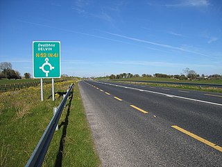
The N52 road is a national secondary road in Ireland. It links the M7 motorway from just south of Nenagh, County Tipperary to the M1 motorway north of Dundalk in County Louth. The route forms a connection between the north east of Ireland and the mid west traversing the midlands. It interchanges with the M6 at Kilbeggan and at Tyrrellspass, the N4 at Mullingar, the N3 at Kells, and the N2 at Ardee before continuing towards Dundalk.

The N12 is a national route in South Africa which runs from George through Beaufort West, Kimberley, Klerksdorp and Johannesburg to eMalahleni.

South Dayi District is one of the eighteen districts in Volta Region, Ghana. Originally it was formerly part of the then-larger Kpando District on 10 March 1989, until the southern part of the district was split off by a decree of president John Agyekum Kufuor on 19 August 2004 to create South Dayi District; thus the remaining part has been retained as Kpando District. The district assembly is located in the western part of Volta Region and has Kpeve as its capital town.

The railway stations in Ghana serve a rail network concentrated in the south of the country.
Kpassa is the capital of Nkwanta North District, a district in the Oti Region of Ghana. The Oti Region was part of the Volta Region of Ghana until 2019. The inhabitants of Kpassa are mostly Konkomba people. The other inhabitants are Basare. The Bassares and famous for their fire dance.There are also Akan, Ewe, Anufo, Krachi and Gonja people. In the past, the inhabitants of Kpassa have mainly engaged in farming. This trend has changed during the past two decades. Younger inhabitants are actively pursuing education and small-scale business activities, while the older ones are into governance. As a result, Kpassa has undergone rapid expansion during these past two decades. The town is expected to expand further once the Eastern Corridor Road Project is completed. In terms of architecture, a returning visitor will easily noticed that the town is rapidly shifting from mud buildings or atakpame to modern block buildings. In fact, most people in the town attach this shift to prestige and affluence in the society. At the current rate, one is expected to find fewer atakpame buildings a decade in the future. The economy of Kpassa is critical to the Volta Region, owing to its engagement in the production of valuable agricultural products such as corn, yam, cassava, millet, groundnuts, pepper, soya beans, and beans, among others.
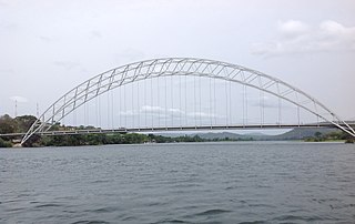
The Adomi Bridge is a latticed steel arch suspension bridge crossing the Volta River at Atimpoku in Ghana in West Africa. It is the first permanent bridge to span the Volta River, which drains south into the Gulf of Guinea, and is Ghana's longest suspension bridge. It provides the main road passage, just south of the Akosombo Dam, between the Eastern Region and the Volta Region of Ghana. It was opened in 1957 by Kwame Nkrumah, Ghana's first president. The iconic crescent-shaped arch bridge is featured in Ghanaian stamps and currency.
The N1 or National Highway 1 is a national highway in Ghana that begins at the border with Ivory Coast at Elubo and runs through Sekondi-Takoradi, Cape Coast, Winneba, Accra and Tema to the border with Togo at Aflao. It is the main highway along the coast of the country, with a total distance of 540 kilometers. The route runs through the Western, Central, Greater Accra and Volta regions of Ghana.
The N3 or National Highway 3 is a national highway in Ghana that begins at Kpong and runs west through Oterkpalu to Koforidua. It is a link between the N2 and N4 in the Eastern region of the country, with a total distance of 40 kilometers.
The IR1 or Inter-Regional Highway 1 is a highway in Ghana that begins at Mankessim in the Central Region and runs through Agona Swedru and Nsawam to Aburi. It runs parallel to the N1 between the Central and Eastern regions, and has a total distance of 142 kilometers. The route runs through the Central, Greater Accra and Eastern regions of Ghana.
The N5 or National Highway 5 is a national highway in Ghana that begins at Adomi in the Eastern region and runs east to Ho, where it intersects with the R26, which travels north to reconnect with the N2. At Ho, the N5 also intersects with the R10 and R55. The N5 spans a distance of 40 kilometers.
The N6 or National Highway 6 is a national highway in Ghana that begins at the Nsawam road junction off the N1 in Accra and runs through Nsawam, Nkawkaw, and Ejisu to Kumasi, where it meets the N4. At Kumasi, the N6 intersects with the N10, R52, R108, and IR5.
The N11 or National Highway 11 is a national highway in Ghana that begins at Bolgatanga in the Upper East Region (N10) and runs east to Bawku, where it intersects with the N2. The N11 is 110.8 km long.
The R40 Regional Highway is a highway that begins at Adenta in the Greater Accra Region and runs through Dodowa and Somanya to Kpong in the Eastern Region. It is also known as the Accra - Dodowa Road.
