
The N3 is a national route in South Africa that connects Johannesburg and Durban, respectively South Africa's largest and third-largest cities. Johannesburg is the financial and commercial heartland of South Africa, while Durban is South Africa's key port and one of the busiest ports in the Southern Hemisphere and is also a holiday destination. Durban is the port through which Johannesburg imports and exports most of its goods. As a result, the N3 is a very busy highway and has a high volume of traffic.

Oregon Route 8, also known as Oregon Highway 8, is an Oregon state highway which serves the western suburbs of Portland. The road is locally known as Canyon Road and Tualatin Valley Highway, and travels through the center of the Tualatin Valley. Oregon 8 is located entirely within Washington County. The portion of the route from US 26 to Oregon Route 47 is part of the National Highway System, listed as a principal arterial.

The Western Bypass is a section of the N1 and the Johannesburg Ring Road located in the city of Johannesburg, South Africa. Known at the time as the Concrete Highway, the freeway was initially opened in 1975 as a route to avoid the city centre of Johannesburg and to provide access to the western areas of the Witwatersrand. From the south, the Western Bypass begins at the Diepkloof Interchange in Soweto, where it splits from the N12 freeway and ends at the Buccleuch Interchange, where it merges with the N3 Eastern Bypass, M1 South and N1 Ben Schoeman freeways.

The N1 is a national route in South Africa that runs from Cape Town through Bloemfontein, Johannesburg, Pretoria and Polokwane to Beit Bridge on the border with Zimbabwe. It forms the first section of the famed Cape to Cairo Road.

State Route 118 is a state highway in the U.S. state of California that runs west to east through Ventura and Los Angeles counties. It travels from State Route 126 at the eastern edge of Ventura immediately northwest of Saticoy, then through Saticoy, in Ventura County east to Interstate 210 near Lake View Terrace in Los Angeles. SR 118 crosses the Santa Susana Pass and the northern rim of the San Fernando Valley along its route.

The R21 / P157 is a major north–south provincial route in eastern Gauteng Province, South Africa. Built in the early 1970s, it remains one of two freeways linking Pretoria with Johannesburg, via the R24. As the eastern of the two freeways, it links the Pretoria city centre with OR Tambo International Airport, the N12 freeway, and Boksburg. Between the Solomon Mahlangu Drive on-ramp in Monument Park, Pretoria, and the N12 in Boksburg, the R21 / P157 is an 8 lane highway and motorway (freeway), with 4 lanes in each direction. It has off-ramps leading to Irene, Olifantsfontein, Benoni, and Kempton Park, including a partial offramp to Atlas Road. The route intersects the N1 Highway near Centurion, the R24 near the airport, the N12 and N17 in Boksburg, and the N3 near Vosloorus on the East Rand, where it ends. The section from the N12 to the N3 is not a freeway. As early as the 1970s there were proposals to extend the R21 / P157 freeway further south and the freeway may be linked with the current eastern terminus of the M2 in Germiston in future.

The R23 is a provincial route in South Africa that links Benoni with Volksrust via Brakpan, Heidelberg and Standerton.

The R24 is a major East-West provincial route in the Gauteng and North West provinces that links OR Tambo International Airport with Rustenburg via Johannesburg, Krugersdorp and Magaliesburg. The process of renaming the streets and freeway that form the route from Krugersdorp eastward to OR Tambo International after anti-apartheid stalwart Albertina Sisulu was completed in 2013.

Koforidua, also popularly known as K-dua or Koftown and now Kofcity, is a city and the capital of Eastern Region in southern Ghana. Koforidua was founded in 1875 by migrants from Ashanti. It is also called New Juaben. The city has a settlement city proper population of 183,727 people as of 2010, Koforidua is an amalgamation of two Municipalities; New Juaben North and South. The city has a blend of colonial and modern architecture.

The N12 is a national route in South Africa which runs from George through Beaufort West, Kimberley, Klerksdorp and Johannesburg to eMalahleni.

The N3 road in Belgium is a national road connecting the capital city Brussels to Aachen in Germany via Leuven, Tienen, Sint-Truiden and Liège. Its course is quite similar to that of European route E40 between Brussels and Aachen, which it intersects 3 times. The road runs through the 3 Belgian regions and the 3 communities.

Põhimaantee nr 2 is a 280-kilometre-long north-south national main road in Estonia. The route follows the same path as the European route E263. The highway starts in Tallinn. From there the main cities passed are Kose, Paide, Põltsamaa, Tartu and Võru. The highway ends in Lüta on the intersection with the T7.
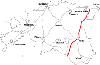
Põhimaantee 3 is a 220-kilometre-long north-south national main road in Estonia. The route follows the same path as the European route E264. The highway starts in Jõhvi. From there the main cities passed are Ahtme and Tartu. The highway ends in Valga on the intersection with the T6.
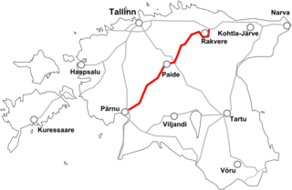
Põhimaantee 5 is a 184-kilometre long west-east national main road in Estonia. The highway starts outside Pärnu. After this the main cities passed are Vändra, Türi, Paide and Rakvere. The highway ends in Sõmeru when intersecting with the T1.
The N1 or National Highway 1 is a national highway in Ghana that begins at the border with Ivory Coast at Elubo and runs through Sekondi-Takoradi, Cape Coast, Winneba, Accra and Tema to the border with Togo at Aflao. It is the main highway along the coast of the country, with a total distance of 540 kilometers. The route runs through the Western, Central, Greater Accra and Volta regions of Ghana.
The N2 or National Highway 2 is a national highway in Ghana that begins at the Tema Motorway interchange at Tema and runs through Hohoe, Nkwanta, Yendi, and Bawku to the border with Burkina Faso at Kulungugu. It is the main north-south highway in the eastern corridor of the country, with a total distance of 640 kilometres (400 mi). The route runs through the Greater Accra, Eastern, Volta, Oti, Northern, North East Region and Upper East regions of Ghana.
The N4 or National Highway 4 is a national highway in Ghana that begins at the Tetteh Quarshie Interchange in Accra and runs through Adenta, Koforidua, and Asokore to join the N6, which continues to Kumasi. It serves as an alternate route from Accra to Kumasi, with a total distance of 110 kilometers. The route runs through the Greater Accra and Eastern regions of Ghana.
The N5 or National Highway 5 is a national highway in Ghana that begins at Adomi in the Eastern region and runs east to Ho, where it intersects with the R26, which travels north to reconnect with the N2. At Ho, the N5 also intersects with the R10 and R55. The N5 spans a distance of 40 kilometers.
The N6 or National Highway 6 is a national highway in Ghana that begins at the Nsawam road junction off the N1 in Accra and runs through Nsawam, Nkawkaw, and Ejisu to Kumasi, where it meets the N4. At Kumasi, the N6 intersects with the N10, R52, R108, and IR5.

Highway 17 is a designation a state highway in the U.S. state of Arkansas. The highway is located mainly in Eastern Arkansas and is split into seven segments, though two sets of segments are directly connected. The first section of the highway is about 4.9 miles (7.9 km) long, with its southern terminus located near Ward Reservoir, in southern Arkansas County, which travels north and ends at a dead-end near La Grue Bayou. The second section is about 53.7 miles (86.4 km) long, starting south of the town of Ethel and ending at U.S. Route 70 (US 70) southwest of Brinkley. The third and longest section begins at US Route 49 north of Brinkley and ends at AR 14 in Newport. The fourth section is about 7.1 miles (11.4 km) long and begins at Arkansas Highway 18 in Diaz and ends at Arkansas Highway 37 west of Tuckerman.
