M-99 is a north–south state trunkline highway in the Lower Peninsula of the US state of Michigan. It runs from the Ohio state border, where it connects to State Route 15 (SR 15), north to Lansing, where it terminates at a junction with Interstate 496 (I-496) and the Capitol Loop. The highway mainly serves local communities along the route as it passes through farm lands in the southern part of the state. One short segment, in Jonesville, is routed concurrently with US Highway 12 (US 12). The segment within Lansing follows Martin Luther King Jr. Boulevard.

Bolgatanga, colloquially known as Bolga, is a town and the capital of the Bolgatanga Municipality and Upper East Region of Ghana, adjacent to the border with Burkina Faso. Bolgatanga has over 2012 settlements and a population of about 66,685 people. Bolgatanga is 161 km to the north of Tamale. Bolgatanga lies in the Red Volta River Valley, with the White Volta River and the cliffs of the Gambaga Escarpment to the south of the town forming the southern boundary of the Upper East Region.
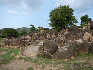
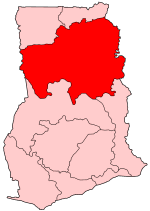
The Upper East Region is located in northern Ghana and is the third smallest of the 16 administrative regions in Ghana. It occupies a total land surface of 8,842 square kilometers or 2.7 per cent of the total land area of Ghana. The Upper East regional capital is Bolgatanga, sometimes referred to as Bolga. Other major towns in the region include Navrongo, Paga, Sandema, Bawku, and Zebilla.

Bawku is a town and is the capital of the Bawku Municipal District, district in the Upper East region of north Ghana, adjacent to the border with Burkina Faso. It is located approximately between latitudes 11o 111 and 100 401 North and longitude 0o 181w and 0o 61 E in the north-eastern corner of the region. The municipality has a total land area of about 257 km2. The Municipality was established by Legislative Instrument (L.I) 2103. The municipality has a total land area of about 257 km2. Bawku has a 2021 settlement population of 119,458 people. Hon. Ayariga Mahama is the Member of Parliament for Bawku Central Constituency.

M-156 is a state trunkline highway in the US state of Michigan. The highway is entirely within Lenawee County and begins in Morenci at the Ohio state line with State Route 108 (SR 108) and runs north to M-34 at Clayton. The highway runs through farm land along Lime Creek outside of the two communities, providing access to the Lake Hudson State Recreation Area. The trunkline dates back to the early 1930s, and has been unchanged since a realignment in 1980.
Zuarungu is a town in the Upper East Region of Ghana east of Bolgatanga. The village is the capital of the Bolgatanga East District. The people living in Zuarungu are part of the Frafra tribe. Frafra and English are commonly spoken.
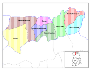
Talensi-Nabdam District is a former district that was located in Upper East Region, Ghana. Originally it was formerly part of the then-larger Bolgatanga District in August 2004. However, on 28 June 2012, it was split oft into two new districts: Talensi District and Nabdam District. The district assembly was located in the central part of Upper East Region and had Tongo as its capital town.

Bawku Central is one of the constituencies represented in the Parliament of Ghana. It elects one Member of Parliament (MP) by the first past the post system of election. Bawku Central is located in the Bawku Municipal district of the Upper East Region of Ghana.

The railway stations in Ghana serve a rail network concentrated in the south of the country.
Zebilla is one of the constituencies represented in the Parliament of Ghana. It elects one Member of Parliament (MP) by the first past the post system of election. Zebilla is located in the Bawku West district of the Upper East Region of Ghana.
Binduri is a constituencies represented in the Parliament of Ghana. It elects one member of parliament (MP) by the first past the post system. Binduri was part of in the Bawku Municipal District of the Upper East Region of Ghana but has since June 2012 become a full district.
The Bolgatanga Technical UniversityBTU, is a public tertiary institution in the Upper East Region of Ghana, West Africa. It is gradually increasing its courses and facilities following the achievement of university status. It was converted into a Technical University during the administration of the former president of Ghana, John Dramani Mahama. The institution was established in 1999 but started rolling out its academic programs in September 2003 as Bolgatanga Polytechnic.
The Anglican Diocese of Tamale, (Ghana) is a diocese of the Church of the Province of West Africa, a member church of the worldwide Anglican Communion and part of the Internal Province of Ghana. The cathedral of the diocese is Bishop Aglionby Memorial Cathedral, Tamale, Ghana, which was built in the 1960s.
The N2 or National Highway 2 is a national highway in Ghana that begins at the Tema Motorway interchange at Tema and runs through Hohoe, Nkwanta, Yendi, and Bawku to the border with Burkina Faso at Kulungugu. It is the main north-south highway in the eastern corridor of the country, with a total distance of 640 kilometres (400 mi). The route runs through the Greater Accra, Eastern, Volta, Oti, Northern, North East Region and Upper East regions of Ghana.
Joseph Kojo Akudibillah is a Ghanaian diplomat and an independent candidate. He is currently Ghana's ambassador to the Vatican.
Bolgatanga East is one of the constituencies represented in the Parliament of Ghana. It elects one Member of Parliament (MP) by the first past the post system of election. The Bolgatanga East constituency is located in the Bolgatanga Municipal District of the Upper East Region of Ghana. This constituency was first known as Bolgatanga before it was divided into Bolgatanga central and Bolgatanga east constituency. Hon. Dominic Akuritinga Ayine represent this constituency in the 6th, 7th and Eighth Parliament of the Fourth Republic of Ghana.
Notre Dame Seminary Senior High School is an all male second cycle educational institution founded by Very Rev. Fr. Armand Lebel. The first batch of thirty-one (31) students were admitted on September 16, 1960. It currently has a population of about 500 students studying either General Science or General Arts. The school is located in Navrongo in the Kasena-Nankana Municipality of the Upper East Region of Ghana.

The Burkina Faso–Ghana border is 602 km in length and runs from the tripoint with Ivory Coast in the west to the tripoint with Togo in the east.
The N10 or National Highway 10 is a national highway in Ghana that begins at Kumasi and runs north to Burkina Faso, where it turns into the N5 of Burkina Faso. This makes it to one of the most important economical connections to Burkina Faso. At Tamale the N10 intersects with N9. At Bolgatanga the N10 intersects with N11. The N10 spans a distance of 578 kilometers.
Agrumatue is a river in the Upper East Region, Ghana. It flows between the cities Bolgatanga and Zuarungu and is also the border between the Bolgatanga Municipal District and the Bolgatanga East District. The river is crossed by N11 road.