Senchi Ntonso | |
|---|---|
 Senchi | |
| Coordinates: 6°13′16″N0°05′13″E / 6.221°N 0.087°E | |
| Country | |
| Region | Eastern Region |
| District | Asuogyaman District |
| Time zone | GMT |
| • Summer (DST) | GMT |
Senchi is a town in the Asuogyaman District of the Eastern Region of Ghana.
Senchi Ntonso | |
|---|---|
| Senchi | |
| Coordinates: 6°13′16″N0°05′13″E / 6.221°N 0.087°E | |
| Country | |
| Region | Eastern Region |
| District | Asuogyaman District |
| Time zone | GMT |
| • Summer (DST) | GMT |
Senchi is a town in the Asuogyaman District of the Eastern Region of Ghana.
Senchi is situated along the west banks of the Volta River, downstream from the Akosombo Dam.
Senchi has a ferry station used for the crossing of the Volta River from the west to the Old Akrade on the eastern side. [1] [2] It was the major crossing for vehicular traffic prior to the completion of the construction of the Adomi Bridge in January 1957. [3] In 2014, it experienced very heavy traffic while the Adomi Bridge was closed to traffic for repairs. [1] [4] [5]
Senchi is well noted as the location of some resorts and guest houses south of the dam on the Volta River. These include Royal Senchi Resort and The Senchi Consensus [6] [7]

Transport in Ghana is accomplished by road, rail, air and water. Ghana's transportation and communications networks are centered in the southern regions, especially the areas in which gold, cocoa, and timber are produced. The northern and central areas are connected through a major road system.

The Forth Road Bridge is a suspension bridge in east central Scotland. The bridge opened in 1964 and at the time was the longest suspension bridge in the world outside the United States. The bridge spans the Firth of Forth, connecting Edinburgh, at South Queensferry, to Fife, at North Queensferry. It replaced a centuries-old ferry service to carry vehicular traffic, cyclists and pedestrians across the Forth; railway crossings are made by the nearby Forth Bridge, opened in 1890.

The James River is a river in Virginia that begins in the Appalachian Mountains and flows 348 miles (560 km) to the Chesapeake Bay. The river length extends to 444 miles (715 km) if the Jackson River is included, the longer of its two headwaters. It is the longest river in Virginia. Jamestown and Williamsburg, Virginia's first colonial capitals, and Richmond, Virginia's current capital, lie on the James River.

The Blackwall Tunnel is a pair of road tunnels underneath the River Thames in east London, England, linking the London Borough of Tower Hamlets with the Royal Borough of Greenwich, and part of the A102 road. The northern portal lies just south of the East India Dock Road (A13) in Blackwall; the southern entrances are just south of The O2 on the Greenwich Peninsula. The road is managed by Transport for London (TfL).

The Woolwich Ferry is a free vehicle and pedestrian ferry across the River Thames in East London, connecting Woolwich on the south bank with North Woolwich on the north. It is licensed and financed by London River Services, the maritime arm of Transport for London (TfL). Around two million passengers use the ferry each year.
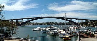
Gladesville Bridge is a heritage-listed concrete arch road bridge that carries Victoria Road over the Parramatta River, linking the Sydney suburbs of Huntleys Point and Drummoyne, in the local government areas of Canada Bay and Hunter's Hill, in New South Wales, Australia. Despite its name, the bridge is not in Gladesville.
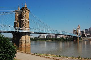
The John A. Roebling Suspension Bridge is a suspension bridge that spans the Ohio River between Cincinnati, Ohio, and Covington, Kentucky. When opened on December 1, 1866, it was the longest suspension bridge in the world at 1,057 feet (322 m) main span, which was later overtaken by John A. Roebling's most famous design of the 1883 Brooklyn Bridge at 1,595.5 feet (486.3 m). Pedestrians use the bridge to get between the hotels, bars, restaurants, and parking lots in Northern Kentucky. The bar and restaurant district at the foot of the bridge on the Kentucky side is known as Roebling Point.

The Akosombo Dam, also known as the Volta Dam, is a hydroelectric dam on the Volta River in southeastern Ghana in the Akosombo gorge and part of the Volta River Authority. The construction of the dam flooded part of the Volta River Basin and led to the subsequent creation of Lake Volta. Lake Volta is the largest man-made lake in the world by surface area. It covers 8,502 square kilometres (3,283 sq mi), which is 3.6% of Ghana's land area. With a volume of 148 cubic kilometers, Lake Volta is the world's third largest man-made lake by volume; the largest being Lake Kariba which contains 185 cubic kilometers of water.

Briton Ferry is a town and community in the county borough of Neath Port Talbot, Wales. The Welsh name may indicate that the church, llan, is protected from the wind, awel. Alternatively, Sawel may be a derivative of Saul, St Paul's earlier name. He once landed at Briton Ferry. An alternative Welsh name unused today is Rhyd y Brython, a direct translation of Briton Ferry. The Normans referred to the River crossing as La Brittonne and Leland in 1540 as Britanne Fery.
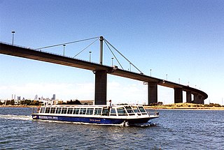
The West Gate Bridge is a steel, box girder, cable-stayed bridge in Melbourne, Victoria, Australia, spanning the Yarra River just north of its mouth into Port Phillip. It carries the West Gate Freeway and is a vital link between the Melbourne central business district (CBD) and western suburbs, with the industrial suburbs in the west, and with the city of Geelong 80 kilometres (50 mi) to the south-west. It is part of one of the busiest road corridors in Australia. The high span bridge was built to allow large cargo ships to access the docks in the Yarra River.

Lake of the Ozarks is a reservoir created by impounding the Osage River in the northern part of the Ozarks in central Missouri. Parts of three smaller tributaries to the Osage are included in the impoundment: the Niangua River, Grandglaize Creek, and Gravois Creek. The lake has a surface area of 54,000 acres (220 km2) and 1,150 miles (1,850 km) of shoreline. The main channel of the Osage Arm stretches 92 miles (148 km) from one end to the other. The total drainage area is over 14,000 square miles (36,000 km2). The lake's serpentine shape has earned it the nickname "the Missouri Dragon", which has, in turn, inspired the names of local institutions such as the Magic Dragon Street Meet.

The Eastern Region is located in the Eastern part of Ghana and is one of the sixteen administrative regions of Ghana. Eastern region is bordered to the east by the Lake Volta, to the north by Bono East Region and Ashanti region, to the west by Ashanti region, to the south by Central region and Greater Accra Region. Akans are the dominant inhabitants and natives of Eastern region and Akan, Ewe, Krobo, Hausa and English are the main spoken languages. The capital town of Eastern Region is Koforidua.The Eastern region is the location of the Akosombo dam and the economy of the Eastern region is dominated by its high-capacity electricity generation. Eastern region covers an area of 19,323 square kilometres, which is about 8.1% of Ghana's total landform.
Atimpoku is a small town in the Eastern Region of Ghana and located along the Volta River. It is the capital of the Asuogyaman District, a district in the Eastern Region of Ghana.
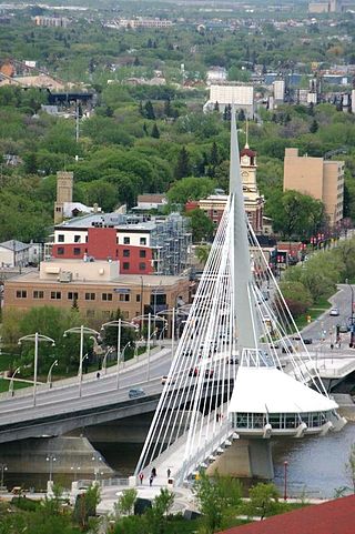
The Provencher Bridge is a set of paired bridges—a four-lane vehicular bridge and a suspended pedestrian bridge —across the Red River in Winnipeg, Manitoba.

Akosombo is a small town in the south of the Asuogyaman District, Eastern Region, Ghana with notable street names of some African countries in the sub-region like Ghana, Congo, Namibia, Lagos-town, and Freetown. It is occupied by people of diverse ethnic backgrounds, like the Akans, Ewe, Krobo and other ethnic groups. Akosombo is north of the Adomi Bridge at Atimpoku, which is a 3 to 5 minute drive away.

The Columbia–Wrightsville Bridge, officially the Veterans Memorial Bridge, spans the Susquehanna River between Columbia and Wrightsville, Pennsylvania, and carries Pennsylvania Route 462 and BicyclePA Route S. Built originally as the Lancaster-York Intercounty Bridge, construction began in 1929, and the bridge opened September 30, 1930. On November 11, 1980, it was officially dedicated as Veterans Memorial Bridge, though it is still referenced locally as the Columbia–Wrightsville Bridge.

Dock Bridge is a pair of vertical lift bridges crossing the Passaic River at Newark, Essex County and Harrison, Hudson County, New Jersey, United States, used exclusively for railroad traffic. It is the seventh crossing from the river's mouth at Newark Bay and is 5.0 miles (8.0 km) upstream from it. Also known as the Amtrak Dock Vertical Lift, it carries Amtrak, NJ Transit, and PATH trains. It is listed on the state and federal registers of historic places.
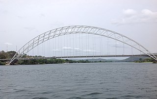
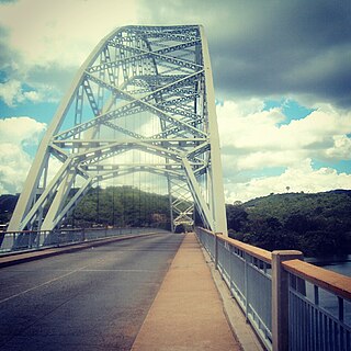
The Adomi Bridge is a latticed steel arch suspension bridge crossing the Volta River at Atimpoku in Ghana in West Africa. It is the first permanent bridge to span the Volta River, which drains south into the Gulf of Guinea, and is Ghana's longest suspension bridge. It provides the main road passage, just south of the Akosombo Dam, between the Eastern Region and the Volta Region of Ghana. It was opened in 1957 by Kwame Nkrumah, Ghana's first president. The iconic crescent-shaped arch bridge is featured in Ghanaian stamps and currency.
The N2 or National Highway 2 is a national highway in Ghana that begins at the Tema Motorway interchange at Tema and runs through Hohoe, Nkwanta, Yendi, and Bawku to the border with Burkina Faso at Kulungugu. It is the main north-south highway in the eastern corridor of the country, with a total distance of 640 kilometres (400 mi). The route runs through the Greater Accra, Eastern, Volta, Oti, Northern, North East Region and Upper East regions of Ghana.
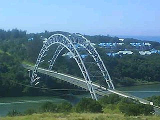
The C. H. Mitchell bridge, also known as the Mtamvuna bridge, is the second longest single span bridge in South Africa. The bridge's deck is suspended by a pair of cable hangers systems, which are supported by a cross-braced double steel arch. It is 206 metres (676 ft) in length and the highest point on its arch is 35 metres (115 ft) above the roadway.