
Transport in Ghana is accomplished by road, rail, air and water. Ghana's transportation and communications networks are centered in the southern regions, especially the areas in which gold, cocoa, and timber are produced. The northern and central areas are connected through a major road system.

The Western Bypass is a section of the N1 and the Johannesburg Ring Road located in the city of Johannesburg, South Africa. Known at the time as the Concrete Highway, the freeway was initially opened in 1975 as a route to avoid the city centre of Johannesburg and to provide access to the western areas of the Witwatersrand. From the south, the Western Bypass begins at the Diepkloof Interchange in Soweto, where it splits from the N12 freeway and ends at the Buccleuch Interchange, where it merges with the N3 Eastern Bypass, M1 South and N1 Ben Schoeman freeways.

The N1 is a national route in South Africa that runs from Cape Town through Bloemfontein, Johannesburg, Pretoria and Polokwane to Beit Bridge on the border with Zimbabwe. It forms the first section of the famed Cape to Cairo Road.

The Greater Accra Region has the smallest area of Ghana's 16 administrative regions, occupying a total land surface of 3,245 square kilometres. This is 1.4 per cent of the total land area of Ghana. It is the second most populated region, before the Ashanti Region, with a population of 5,455,692 in 2021, accounting for 17.7 per cent of Ghana's total population.

The Rural Municipality of Shellbrook No. 493 is a rural municipality (RM) in the Canadian province of Saskatchewan within Census Division No. 16 and SARM Division No. 5. It is located in the north-central portion of the province west of the City of Prince Albert.

South Dayi District is one of the eighteen districts in Volta Region, Ghana. Originally it was formerly part of the then-larger Kpando District on 10 March 1989, until the southern part of the district was split off by a decree of president John Agyekum Kufuor on 19 August 2004 to create South Dayi District; thus the remaining part has been retained as Kpando District. The district assembly is located in the western part of Volta Region and has Kpeve as its capital town.

Roads in Ghana form a network of varied quality and capacity. Responsibility for the road network differs between trunk and non-trunk routes. Trunk roads, which are the most important roads, are administered by the Ghana Highway Authority, which was established in 1974 to develop the trunk road network. Ghana's 13,367 km of trunk roads accounts for 33% of the total road network of 40,186 km. The Department of Feeder Roads is responsible for the construction and maintenance of feeder roads in Ghana, while responsibility for urban roads lies with the Department of Urban Roads.

Põhimaantee nr 2 is a 280-kilometre-long north-south national main road in Estonia. The route follows the same path as the European route E263. The highway starts in Tallinn. From there the main cities passed are Kose, Paide, Põltsamaa, Tartu and Võru. The highway ends in Lüta on the intersection with the T7.
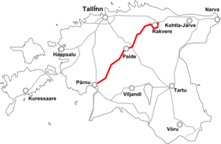
Põhimaantee 5 is a 184-kilometre long west-east national main road in Estonia. The highway starts outside Pärnu. After this the main cities passed are Vändra, Türi, Paide and Rakvere. The highway ends in Sõmeru when intersecting with the T1.
The N1 or National Highway 1 is a national highway in Ghana that begins at the border with Ivory Coast at Elubo and runs through Sekondi-Takoradi, Cape Coast, Winneba, Accra and Tema to the border with Togo at Aflao. It is the main highway along the coast of the country, with a total distance of 540 kilometers. The route runs through the Western, Central, Greater Accra and Volta regions of Ghana.
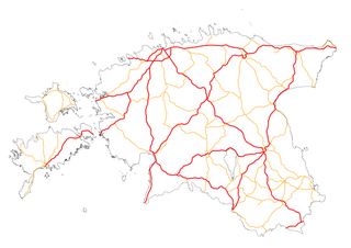
Highways in Estonia are the main transport network in Estonia. The Estonian national classification includes several classes of highways:
The N2 or National Highway 2 is a national highway in Ghana that begins at the Tema Motorway interchange at Tema and runs through Hohoe, Nkwanta, Yendi, and Bawku to the border with Burkina Faso at Kulungugu. It is the main north-south highway in the eastern corridor of the country, with a total distance of 640 kilometres (400 mi). The route runs through the Greater Accra, Eastern, Volta, Oti, Northern, North East Region and Upper East regions of Ghana.
The N3 or National Highway 3 is a national highway in Ghana that begins at Kpong and runs west through Oterkpalu to Koforidua. It is a link between the N2 and N4 in the Eastern region of the country, with a total distance of 40 kilometers.
The N4 or National Highway 4 is a national highway in Ghana that begins at the Tetteh Quarshie Interchange in Accra and runs through Adenta, Koforidua, and Asokore to join the N6, which continues to Kumasi. It serves as an alternate route from Accra to Kumasi, with a total distance of 110 kilometers. The route runs through the Greater Accra and Eastern regions of Ghana.
The N6 or National Highway 6 is a national highway in Ghana that begins at the Nsawam road junction off the N1 in Accra and runs through Nsawam, Nkawkaw, and Ejisu to Kumasi, where it meets the N4. At Kumasi, the N6 intersects with the N10, R52, R108, and IR5.
The N10 or National Highway 10 is a national highway in Ghana that begins at Kumasi and runs north to Burkina Faso, where it turns into the N5 of Burkina Faso. This makes it to one of the most important economical connections to Burkina Faso. At Tamale the N10 intersects with N9. At Bolgatanga the N10 intersects with N11. The N10 spans a distance of 578 kilometers.

Highway 17 is a designation a state highway in the U.S. state of Arkansas. The highway is located mainly in Eastern Arkansas and is split into seven segments, though two sets of segments are directly connected. The first section of the highway is about 4.9 miles (7.9 km) long, with its southern terminus located near Ward Reservoir, in southern Arkansas County, which travels north and ends at a dead-end near La Grue Bayou. The second section is about 53.7 miles (86.4 km) long, starting south of the town of Ethel and ending at U.S. Route 70 (US 70) southwest of Brinkley. The third and longest section begins at US Route 49 north of Brinkley and ends at AR 14 in Newport. The fourth section is about 7.1 miles (11.4 km) long and begins at Arkansas Highway 18 in Diaz and ends at Arkansas Highway 37 west of Tuckerman.
The R10 Regional Highway is a highway in the Volta Region of Ghana. It begins at Tokor, on the northern edge of Denu and runs north through Dzodze, Agotime-Ziope and Agortime-Kpetoe ending at the regional capital of Ho. It is also known as the Ho - Denu road. It is an important link from Ho, the capital of the Volta Region which borders Togo and Denu near Aflao which is the main border crossing in the south between Ghana and Togo. The total length is about ninety-nine (99) kilometres.
The R12 Regional Highway is a highway in the Volta Region of Ghana. It starts from Akatsi in the west to Akanu on the border with Togo. It is 30 kilometres in length.
The R14 Regional Highway is a highway which runs entirely within the Volta Region of Ghana, linking the Akatsi South District and the Agotime Ziope District. It is also known as the Akatsi-Ziope road.
