Kumasi

Last updated

Kumasi
Kronum Kumasi 2018-11-08 (130246).jpg
Manhyia Palace Museum, Kumasi, Ghana.jpg
Kumasi Street and Taxicabs - Panorama.jpg
Fort Kumasi and Millitary Museum (10).jpg
Top to Bottom; Left to Right: Kronom suburb in Kumasi, Manhyia Palace, A street in Adum, Armed Forces Museum.
Flag of Kumasi.png
Ashanti (Ashanti Region) location map.png
Red pog.svg
Kumasi
Ghana adm location map.svg
Red pog.svg
Kumasi
Africa location map.svg
Red pog.svg
Kumasi
Coordinates: 06°42′00″N01°37′30″W / 6.70000°N 1.62500°W / 6.70000; -1.62500
Country Ghana
Administrative division Ashanti
Municipality Kumasi Metropolitan
Founded1680
Government
  TypeMayor–council
  MayorSamuel Pyne
Area
[1]
   City 299 km2 (115 sq mi)
Elevation
250 m (820 ft)
Population
 (2021)
   City 443,981 [2]
   Urban
3,490,030 [3]
Time zone UTC
Postal codes
AK000-AK911
Area code 032
Website kma.gov.gh

Kumasi (historically spelled Comassie or Coomassie, usually spelled Kumase in Twi language) [4] [5] is a city in the Ashanti Region, and is among the largest metropolitan areas in Ghana. Kumasi is located in a rain forest region near Lake Bosomtwe, and is the commercial, industrial, and cultural capital of the historical Ashanti Empire. Kumasi is approximately 500 kilometres (300 mi) north of the Equator and 200 kilometres (100 mi) north of the Gulf of Guinea. Kumasi is alternatively known as "The Garden City" [6] because of its many species of flowers and plants in the past. It is also called Oseikrom, after Osei Kofi Tutu I who was a king in the Ashanti empire.

Contents

Kumasi is the second-largest city in Ghana, after the capital, Accra. [7] The Central Business District of Kumasi includes areas such as Adum, Bantama, Kejetia, Asawasi, Pampaso, and Bompata (popularly called Roman Hill), with a concentration of banks, department stalls, and hotels. Economic activities in Kumasi include financial and commercial sectors, pottery, clothing weaving, Weaving of basket and textiles. There is a significant timber processing community in Kumasi that serves the domestic market. Bantama High Street and Prempeh II Street in Bantama and Adum, respectively, are the business and entertainment hubs in Kumasi.[ citation needed ]

History

Origins

Kente weaver on Adum Street in Kumasi, Ghana, 1819 BOWDICH(1819) p344 PLATE 9 - COOMASSIE, PART OF ADAM STREET.jpg
Kente weaver on Adum Street in Kumasi, Ghana, 1819
Lake Bosomtwe Lake Bosumtwi1, Ghana.jpg

There is evidence that the area around Kumasi has been kept cleared since the Neolithic age and that the first human settlement was at Lake Bosomtwe.[ citation needed ]

Etymology

The name Kumasi was derived from the Twi language, meaning 'the Kum tree survived' or 'under the Kum tree'. The word "asi" means 'under', 'down', 'below' or 'something that has endured or survived'.[ citation needed ]

Around the end of the 17th century, the Ashanti Kingdom's chief Fetish Priest, Okomfo Anokye planted three kum trees at different places: one at Kwaaman, ruled by the Nananom Ayokofuo; a second one at Apemso-Bankofo, ruled by Nananom Aduanafuo; and a third at a village near Fomena and Amoafo called Oboani, which was ruled by Nananom Ɛkoɔnafuo. Komfuo wanted to see which of these would become a great city for the kingdom, as he was directed by the oracles. The kum tree at Kwaaman flourished so vigorously that the King and his people often sat underneath, and so Kwaaman became Kum-ase, meaning 'under kum'.[ citation needed ]

The tree at Oboani was, however, very tiny and for no apparent reason, relatively short. According to oral tradition, this small tree produced other trees that were all small in size. The name of the village was changed to Kuma, meaning 'small kum'.[ citation needed ]

The kum tree at Apemso-Bankofo did not grow at all. After a few weeks the leaves withered and the tree fell down; so it was said that the village's kum tree was dead, and the village became Kum-awu, later Kumawu. [4]

Ashanti Empire

Bowdich's sketch of Kumasi c. 1817 BOWDICH(1819) p364 PLATE 11 - SKETCH OF COOMASSIE.jpg
Bowdich's sketch of Kumasi c. 1817

The city rose to prominence in 1695, when it became the capital of the Ashanti Empire due to the activities of its ruler, Osei Tutu. [9] The ruler of Kumasi, known as the Asantehene, also served as the ruler of the empire. With their 1701 victory over Denkyira, the Ashanti empire became the primary state among the Ashantis. [10] In 1718–19, Aowin King Ebirimoro invaded Kumasi and sacked the capital. [11] Asantehene Opoku Ware I was able to "beat back" this invasion. [12]

European sources in the late 19th century mentioned the city's neatness such as the account of F. Boyle in 1874 who stated Kumasi's smell "are never those of sewage" as well as Brackenbury, who wrote around 1873 that "the streets are generally very broad and clean, and ornamented with many beautiful banyan-trees affording grateful shade from the powerful rays of the sun." [13] In contrast, William Butler described the city as 'a filthier, and far more blood-stained collection of mud and wattle hovels than any other village in the forest.' [14] Parts of the city, including the then royal residence, were burnt by the British in the Third Anglo-Ashanti War of 1874. [15] Native carriers were generally blamed for torching the city, and British engineers made strenuous efforts to quell the fires. [16]

Burning of Kumasi in 1874 depicted by Henry Morton Stanley Burning of Coomassie (Kumasi).png
Burning of Kumasi in 1874 depicted by Henry Morton Stanley

In 1888, R. Austin Freeman was disappointed with the ruins of Kumasi following the British destruction in 1874 and the Ashanti civil war before 1888.

Kumasi was a great disappointment to me, and my disappointment increased as I walked round and examined the town. It was not merely that so little existed, but that so much had been destroyed. As it stands, or then stood, the town was nothing more than a large clearing in the forest, over which were scattered, somewhat irregularly, groups of houses. The paths were dirty and ill kept, and between the groups of houses large patches of waste ground intervened, and on these, amidst the tall, coarse grass that covered them, were to be seen the remains of houses that had once occupied them. These houses once stood in wide and regular streets, but since the destruction of the city in 1874 the natives do not seem to have had heart to rebuild them. Yet there remained some few vestiges to show what Kumasi had been in its palmy days... A few broad, well-kept streets still existed, lined by houses, [of] ... admirable construction, careful and artistic finish and excellent repair...

R. Austin Freeman. [17]

Population of Kumasi during the time of the Ashanti Empire varied. In the early 19th century, Ashanti sources estimated a populace of 100,000 while European sources gave a figure around 12–15,000. [17] According to historian Ivor Wilks, the city may have had a population of 40,000 in the 1860s. [18]

Lady Mary Alice Hodgson, the first English lady to visit Ashanti, wrote "The Siege of Kumasi", an account of the siege of the fort by the nationals of Ashanti and of the subsequent march to the coast. [19] (She was the daughter of Hon. W. A. G. Young, C.M.G., former governor of the Gold Coast, and the wife of Sir Frederick Mitchell Hodgson, K.C.M.G., the governor of the Gold Coast in 1900. [19] )

Colonial era

Kings Way Road in Kumasi, 1925 The National Archives UK - CO 1069-37-39.jpg
Kings Way Road in Kumasi, 1925

In 1926, following the return of the Ashanti King Prempeh I after 30-year in exile in Seychelles Island, Kumasi was vested with ceremonial control over the Ashanti sub-states. The full role of king was restored by the colonial administration in 1935. The city holds an important place in the history of the Ashanti people, as legend claims that it was here Okomfo Anokye received the golden stool, an embodiment of the soul of Ashanti nation. [20]

Geography

The city features a tropical wet and dry climate, with relatively constant temperatures throughout the course of the year. Kumasi averages around 1400 mm (55") of rain per year.[ citation needed ]

The city almost features two rainy seasons: a longer season from March through July and a shorter rainy season from September to November.

The month of February through to November is one long wet season, with a relative lull in precipitation in August. Similar to the rest of West Africa, Kumasi experiences the harmattan during the "low sun" months. Lasting from December to February, the harmattan is the primary source of the city's dry season.

Climate

Like other parts of Ghana, Kumasi has a tropical savanna climate (Köppen climate classification Aw), with a wet season and a dry season and the temperature being hot year-round. The average annual high temperature is 30.7 °C (87.3 °F), while the average annual low temperature is 21.5 °C (70.7 °F). The hottest time of year is from February to May, around the time the wet season starts. February has the highest average high at 33.5 °C (92.3 °F). April has the highest average low at 22.4 °C (72.3 °F). August has the lowest average high at 27.7 °C (81.9 °F). January has the lowest average low at 20.4 °C (68.7 °F).

Kumasi receives 1,402.4 millimetres (55.21 in) of rain over 128 precipitation days, with a distinct wet and dry season like the rest of Ghana. The dry season is short, lasting from November to February. June, the wettest month, receives 214.3 millimetres (8.44 in) of rainfall over 17 precipitation days on average. Kumasi receives 1951.8 hours of sunshine annually on average, with the sunshine being distributed fairly evenly across the year, with a noticeable dip from June to October. March receives the most sunshine, while August receives the least.

Climate data for Kumasi (1991–2020 normals, extremes 1984–2020)
MonthJanFebMarAprMayJunJulAugSepOctNovDecYear
Record high °C (°F)37.5
(99.5)
38.9
(102.0)
38.5
(101.3)
36.4
(97.5)
35.2
(95.4)
33.9
(93.0)
32.5
(90.5)
32.6
(90.7)
33.1
(91.6)
33.9
(93.0)
36.0
(96.8)
35.9
(96.6)
38.9
(102.0)
Mean daily maximum °C (°F)33.2
(91.8)
34.5
(94.1)
33.9
(93.0)
32.8
(91.0)
32.0
(89.6)
30.3
(86.5)
28.8
(83.8)
28.4
(83.1)
29.6
(85.3)
31.0
(87.8)
32.2
(90.0)
32.2
(90.0)
31.6
(88.9)
Daily mean °C (°F)27.4
(81.3)
28.8
(83.8)
28.5
(83.3)
28.0
(82.4)
27.5
(81.5)
26.3
(79.3)
25.3
(77.5)
24.9
(76.8)
25.8
(78.4)
26.6
(79.9)
27.4
(81.3)
27.3
(81.1)
27.0
(80.6)
Mean daily minimum °C (°F)21.7
(71.1)
23.1
(73.6)
23.2
(73.8)
23.1
(73.6)
23.0
(73.4)
22.3
(72.1)
21.8
(71.2)
21.5
(70.7)
21.9
(71.4)
22.2
(72.0)
22.6
(72.7)
22.3
(72.1)
22.4
(72.3)
Record low °C (°F)11.7
(53.1)
13.3
(55.9)
17.8
(64.0)
18.8
(65.8)
18.8
(65.8)
18.2
(64.8)
17.2
(63.0)
16.1
(61.0)
18.3
(64.9)
15.6
(60.1)
13.9
(57.0)
10.6
(51.1)
10.6
(51.1)
Average precipitation mm (inches)24.8
(0.98)
49.0
(1.93)
109.9
(4.33)
163.6
(6.44)
174.0
(6.85)
227.3
(8.95)
125.6
(4.94)
68.8
(2.71)
175.1
(6.89)
175.6
(6.91)
50.1
(1.97)
27.6
(1.09)
1,371.4
(53.99)
Average precipitation days (≥ 1.0 mm)1.43.77.79.510.912.38.36.912.013.25.62.293.7
Mean monthly sunshine hours 178.5177.4187.8192.3191.5135.298.875.993.7159.4196.2180.51,867.2
Source 1: NOAA [21]
Source 2: Sistema de Classification Bioclimática Mundial (extremes 1984–1990) [22]

Culture

Otumfuo Osei Tutu II 20th anniversary celebration Otumfuo Osei Tutu II 20th anniversary celebration 3.jpg
Otumfuo Osei Tutu II 20th anniversary celebration

Features of the city include Fort Kumasi (built by in 1896 to replace an Asante fort and now a museum) and the Kumasi Hat Museum. Royal Asante attractions include the Kumasi National Cultural Centre (including the Prempeh II Jubilee Museum with Asante regalia with a reproduction of the golden stool), the Okomfo Anokye Sword, the Asantehene's Palace (built in 1972), and the Manhyia Palace, dating from 1925, now a museum. [23]

Places of worship

St Peter's Cathedral Basilica, Kumasi St Peter's Cathedral Basilica Kumasi (4).jpg
St Peter's Cathedral Basilica, Kumasi

Among the places of worship, which are predominantly Christian churches and temples, are: Methodist Church, Presbyterian Church of Ghana, Church of the Province of West Africa, (Anglican Communion), Seventh-day Adventist Church Evangelical Presbyterian Church, Ghana (World Communion of Reformed Churches), Christ Apostolic Church International (which was the first Pentecostal church in Ghana) Ghana Baptist Convention (Baptist World Alliance), Lighthouse Chapel International, Church of Pentecost, Assemblies of God, and Catholic Church Archdiocese of Kumasi (Catholic Church). [24] There are also Muslim mosques which include: Kumasi Central Mosque, Ahmadiyya mosque, Alhaj mosque, Kaase-Nhyiaeso mosque and Rahman mosque.

Economy

The main occupations in Kumasi are professional, such as services and manufacturing.

Mining and exports

Manufacturing

Kumasi has 50% of the timber industry of Ghana, and the Kaasi Industrial Area plays an important role in the local industry. The Guinness Ghana Breweries are based in Kumasi.

Energy

Solar panels are prevalent in Kumasi and throughout the Ashanti region. Solar energy technology is a major energy source and contributor to electricity generation in the region.

Commerce

Much of the shopping and trading activity in the city takes place at Kumasi's shopping streets, in and around Kejetia Market and Adum. These two areas border each other. There is also heavy economic activities at Bantama and Asafo. Asafo in particular is the printing hub of Kumasi. Most of the printing done in Kumasi and Ashanti Region as a whole is done at Asafo. Kumasi's Ahwiaa (a sub-town in Kumasi) is also well noted for its wood carvings and arts.

FM Stations

Education

Kwame Nkrumah University of Science and Technology (KNUST) - Side view of the College of Architecture and Planning Kwame Nkrumah University of Science and Technology (KNUST) - Side view of the College of Architecture and Planning.JPG
Kwame Nkrumah University of Science and Technology (KNUST) – Side view of the College of Architecture and Planning

Primary school

There are both government-assisted primary schools in Kumasi and also private primary schools in Kumasi which educate boys and girls between the ages from 6 to 15.

Secondary education

There are elite all-boys and all-girls senior high schools such as Prempeh College, Kumasi High School, T I Ahmadiyya School, Opoku Ware School, Yaa Asantewaa Girls' Senior High School and St. Louis Senior High School in Kumasi. There are also many elite mixed senior high schools such as Kumasi Academy and Anglican Senior High School, and a host of other public secondary schools, as well as their private counterparts in the city.

Tertiary institutions

The Kwame Nkrumah University of Science and Technology, Kumasi (formerly the Kumasi College of Technology) is the biggest university in the Ashanti Region and the first biggest in Ghana followed by the University of Ghana. Former Secretary-General of the United Nations, Kofi Annan attended this institution. A number of other public and private universities and tertiary institutions have since been founded in Kumasi, some of which are listed below.

InstitutionLocationPrivate/ PublicAffiliation
Kwame Nkrumah University of Science and Technology Bomso to AnwomasoPublic
Wesley College of Education Tafo Public
St Louis College of EducationMmromPublic
Garden City University CollegeKenyasePrivateKwame Nkrumah University of Science and Technology
Christian Service University CollegeSantasiPrivateUniversity of Ghana
Ghana Baptist University CollegeAmakomPrivateUniversity of Cape Coast
Valley View University (Kumasi Campus)OduomPrivate
University College of Management Studies (Kumasi Campus)AyeduasePrivate
Christ Apostolic University CollegeKwadasoPrivate
Kessben UniversityLake RoadPrivateAkenten Appiah-Menka University of Skills Training and Entrepreneurial Development (est. 2020)

formerly the University of Education, Winneba (Kumasi Campus) Tanoso

Transportation

Air

Kumasi is served by the Kumasi Airport. As of May 2020, two airlines offered regularly scheduled flights to Accra. Airlines servicing the airport included Africa World Airlines and Passion Air. In 2013, the Government of Ghana approved expansion plans to the Kumasi Airport to service international flights into the region. The airport was renovated and completed by October 2022. [27]

Bus and taxicab

There is public transportation from Kumasi to major cities such as Accra; Tamale, Mim, Ahafo  ; Cape Coast, Sunyani; Takoradi; Tema; Ho; Wa; Bolgatanga; Elubo; Aflao, Techiman; Public transport in the city is provided by transit buses, a mix of privately owned mini-buses known as tro-tros , taxicabs and buses. Tro-tros are usually converted mini-buses that run regular, well-known routes. Some taxis also run regular routes, which cost more but provide for a more comfortable ride.

In 2002, the city introduced the metro bus services, a rapid transit system for public road transport in Kumasi (MetroMass). [28] This was to reduce congestion on roads and to make a larger and more organized bus routine system in the city. [29]

In 2017, Uber introduced services in Kumasi, a year after a successful introduction in Accra.

Rail

Kumasi is served by the railway lines to Sekondi-Takoradi and Accra. The train service has been suspended for several years because of damaged track, bridges and locomotives. Currently, no trains run to and from Kumasi due to the collapse of the railway corporation. A $6 billion project to upgrade the railways was due to get underway in 2011. [30]

Port

As of 2011, construction of the Boankra Inland Port, about 25 kilometres (16 mi) away, has come to a halt. [31]

Sports

Kumasi Sports Stadium Kumasi900.JPG
Kumasi Sports Stadium

The local football (soccer) team, the Kumasi Asante Kotoko has won several national and continental trophies and awards, and serves as a rival to the Accra-based Hearts of Oak. Their Kumasi Sports Stadium, also known as Baba Yara Stadium, was built in 1959, renovated in 1978, and again in 2007 with a seating capacity of 40,000. [32] It is also the home of King Faisal Football Club, a premier division side.

There is the Royal Golf Club which has the Asantehene as president. Former Leeds United and Ghana national football team footballer Tony Yeboah and professional wrestler Kofi Kingston was born in Kumasi, by the real name Kofi Sarkodie-Mensah.

Healthcare

Komfo Anokye Teaching Hospital Komfo Anokye Teaching Hospital, Kumasi, Ghana.jpg
Komfo Anokye Teaching Hospital

Kumasi has the Komfo Anokye Teaching Hospital to support medical training at the university, the West End Hospital, several other private hospitals, public clinics and hospitals. Recommended private medical facilities include Kumasi Rabito Clinic located at Ahondwo-Daban Kumasi behind the Unity Oil Filling Station. There is also the KNUST hospital that serves people in the university and surrounding communities.

Recreational parks and gardens

Kumasi has four recreational parks which are opened to the public. The list of recreational parks are Abbey's Park which is located some few meters away from Kejetia, Jackson's Park, Hero's Park located on the same premises as the Baba Yara Sports Stadium, and finally the Rattray Park which was commissioned in 2015.

International relations

Twin towns and sister cities

Kumasi is twinned with:

Country City County / district / region / state Date
Flag of Cote d'Ivoire.svg Ivory Coast AbidjanLogo.gif Abidjan AbidjanLogo.svg Lagunes 2004
Treichville
Flag of the United States.svg US Flag of Atlanta.svg Atlanta Flag of Georgia (U.S. state).svg Georgia 2010
Flag of the Netherlands.svg Netherlands Almere vlag.svg Almere Flag of Flevoland.svg Flevoland 2001
Flag of the United States.svg US Charlotte Flag of North Carolina.svg North Carolina 1996
Flag of the United States.svg US Flag of Columbus, Ohio.svg Columbus Flag of Ohio.svg Ohio 2008
Flag of Canada (Pantone).svg Canada Kitchener Flag of Ontario.svg Ontario 2010
Flag of the United States.svg US NewarkNJ flag.jpg Newark Flag of New Jersey.svg New Jersey 1999
Flag of South Africa.svg South Africa Tshwane Gauteng 2010
Flag of the United States.svg US Winston-Salem Flag of North Carolina.svg North Carolina 2001
Flag of the United Kingdom.svg UK Methilhill Flag of United Kingdom.svg Scotland2017
*Numbers in date column list the year of twinning.

Notable people

See also

Related Research Articles

Osei Kofi Tutu I was one of the founders of the Ashanti Empire, assisted by Okomfo Anokye, his chief priest and a distance relative from the town of Awukugua - Akuapem. The Asante comes from the Akan ethnic group of West Africa. Osei Tutu I led an alliance of Asante states against the regional hegemony, the Denkyira, completely defeating them. He ruled the Kwaman State between c.1680/c.1695-1701 and he ruled the Ashanti Empire from late 1701-c.1717.

<span class="mw-page-title-main">Otumfuo Nana Osei Tutu II</span> Ghanaian monarch of Asante

Osei Tutu II is the 16th Asantehene, enstooled on 26 April 1999. By name, Otumfuo Osei Tutu II is in direct succession to the 17th-century founder of the Ashanti Empire, Otumfuo Osei Tutu I. He is also the Chancellor of the Kwame Nkrumah University of Science and Technology. Otumfuo Osei Tutu II is the Grand Patron of the Grand Lodge of Ghana and the Sword Bearer of the United Grand Lodge of England.

Okomfo Anokye (c.1655-c.1717?/c.1719) was the first priest (Okomfo) of the Ashanti Empire. Anokye is known for his participation in the expansion of the empire. He was also the codifier of the constitution and laws of the Ashanti Empire.

<span class="mw-page-title-main">Ashanti Region</span> Region of Ghana

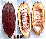
The Ashanti Region is located in the southern part of Ghana and is the third largest of 16 administrative regions, occupying a total land surface of 24,389 km2 (9,417 sq mi) and making up 10.2 percent of the total land area of Ghana. It is the most populated region in Ghana, with a population of 5,440,463 according to the 2021 census, accounting for around one-fifth of Ghana's total population. The Ashanti Region is known for its gold bar and cocoa production. The largest city and capital of Ashanti is Kumasi.

Opoku Ware I was the 2nd Asantehene of Oyoko heritage, who ruled the Ashanti Empire. Between 1718 and 1722, Opoku Ware became Asantehene during a period of civil disorder after the death of the 1st Asanthene. From 1720 to 1721, Opoku established his power.

<span class="mw-page-title-main">Asante Kotoko S.C.</span> Association football club based in Kumasi

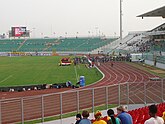
Asante Kotoko Sporting Club, simply known as Asante Kotoko, is a professional football club founded on 31 August 1935 and based in Kumasi in the Ashanti Region of Ghana. Nicknamed the Porcupine Warriors, they compete in the Ghana Premier League and play their home matches at the Baba Yara Stadium in Amakom, Kumasi.

<span class="mw-page-title-main">Kumasi Metropolitan Assembly</span> Metropolitan district in Ashanti region, Ghana

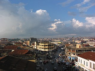
Kumasi Metropolitan Assembly is one of the 261 Metropolitan, Municipal and District Assemblies (MMDAs) in Ghana. It forms part of the forty-three districts in Ashanti Region, Ghana with Kumasi being its administrative capital. The metropolis is located in the central part of Ashanti Region and has Kumasi as its capital city.With a projected population of over two million and an annual growth rate of about 5.4%, it is a rapidly expanding metropolis. The Metropolis is about 254 kilometers long, with a centrally located commercial area and a largely circular physical structure.The fast rate of urbanization is confirmed by estimates that 48%, 46%, and 60% of the Metropolis are rural, peri-urban, and urban, respectively.

<span class="mw-page-title-main">Golden Stool</span> Throne of Ashanti kings

The Golden Stool is the royal and divine throne of kings of the Ashanti people and the ultimate symbol of power in Asante. According to legend, Okomfo Anokye, High Priest and one of the two chief founders of the Asante Confederacy, caused the stool to descend from the sky and land on the lap of the first Asante king, Osei Tutu. Such seats were traditionally symbolic of a chieftain's leadership, but the Golden Stool is believed to house the spirit of the Asante nation—living, dead and yet to be born.

Articles related to Ghana include:

<span class="mw-page-title-main">Ashanti Empire</span> Former Akan empire centred on present-day Ghana

The Asante Empire, today commonly called the Ashanti Empire, was an Akan state that lasted from 1701 to 1901, in what is now modern-day Ghana. It expanded from the Ashanti Region to include most of Ghana and also parts of Ivory Coast and Togo. Due to the empire's military prowess, wealth, architecture, sophisticated hierarchy and culture, the Ashanti Empire has been extensively studied and has more historic records written by European, primarily British, authors than any other indigenous culture of sub-Saharan Africa.

<span class="mw-page-title-main">Opoku Ware II</span> Asantehene of Asanteman

Otumfuo Opoku Ware II was the 15th Asantehene. He succeeded his uncle Osei Tutu Agyeman Prempeh II on 27 July 1970. He ruled for 29 years until his death in February 1999. He was succeeded by Otumfuo Nana Osei Tutu II.

<span class="mw-page-title-main">Asante people</span> Nation and ethnic group in Ghana

The Asante, also known as Ashanti, are part of the Akan ethnic group and are native to the Ashanti Region of modern-day Ghana. Asantes are the last group to emerge out of the various Akan civilisations. Twi is spoken by over nine million Asante people as a first or second language.

Osei Kyeretwie Senior High School is a coed boarding school in Kumasi, Ashanti Region, Ghana.

<span class="mw-page-title-main">Akrafena</span> Ashanti swords originating from Ghana

An Akrafena is an Ashanti sword, originally meant for warfare but also forming part of Ashanti heraldry. The foremost example of an akrafena is the Mponponsuo, which belonged to Opoku Ware II. It has survived to the present day because it is still occasionally used in ceremonies, such as the Akwasidae Festival.

Asanteman Senior High School is a co-educational second-cycle institution in Kumasi in the Ashanti Region of Ghana.

<span class="mw-page-title-main">History of Kumasi</span> Kumasi is a city in the Ashanti Region of Ghana in Africa

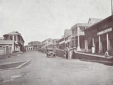
The history of Kumasi dates to the late 17th century when it emerged as the capital of the Ashanti Empire. Although various oral sources differ on the origin of Kumasi, majority agree it emerged as the capital of Ashanti under Osei Kofi Tutu I in the late 17th century. In the early 18th century, Kumasi was invaded and sacked by the Aowin but the invasion was curbed by Asantehene Opoku Ware I. 19th century written accounts by European visitors described the neatness and sophistication of the city. The population of Kumasi under the Ashanti Empire varies per source. The city was ransacked by the British Empire in 1874 during the Anglo-Ashanti Wars. A Civil war occurred within the 1880s which led to further decline of Kumasi. Another British invasion of the city occurred within 1895—1896 as Kumasi was left in ruins.

<span class="mw-page-title-main">Ramseyer Memorial Presbyterian Church</span> Presbyterian Church in Kumasi, Ghana

The Ramseyer Memorial Presbyterian Church, originally named the Basel Mission Church, Kumasi and later the Ebenezer Presbyterian Church, is a historic Protestant church located in the suburb of Adum in Kumasi, the capital of the Ashanti Region of Ghana. The church is affiliated to the Presbyterian Church of Ghana. It was founded in 1896 by Fritz Ramseyer, a Swiss-born Basel missionary who was captured by the Asante in 1869. The stone church house was built by the early Basel missionaries led by the technical staff member and building technologist, Fritz Ramseyer as well as the missionary-architect, Karl Epting in 1907. Liturgy is conducted in English and the Asante Twi language.

<span class="mw-page-title-main">Fritz Ramseyer</span> Swiss missionary and builder

Friedrich Augustus Louis Ramseyer also Fritz Ramseyer was a Swiss-born Basel missionary, who was captured by the Asante in 1869 in colonial Ghana, together with his wife Rosa Louise Ramseyer, Basel mission technical staff, Johannes Kühne and French trader, Marie-Joseph Bonnat. Ramseyer was later released in 1874 and pioneered the Christian mission in Kumasi and the rest of Asante. Additionally, he spearheaded the planting of churches in Abetifi. Apart from his evangelism, Ramseyer was instrumental in the expansion of opportunities in the fields of education, artisan industry training, land acquisition for building design and manpower development in the areas he lived and worked in.

The political organization of the historical Ashanti Empire was characterized by stools which denoted "offices" that were associated with a particular authority. The Golden Stool was the most powerful of all, because it was the office of the King of the Ashanti Empire. Scholars such as Jan Vansina have described the governance of the Ashanti Empire as a federation where state affairs were regulated by a council of elders headed by the king, who was simply primus inter pares.

<span class="mw-page-title-main">Konadu Yaadom</span> Asantehemaa (queen-mother) of Asante

Konadu Yaadom, also Kwadu Yaadom was the fourth Asantehemaa of the Ashanti Empire, whose multiple marriages and spiritual influence meant that she became an important and powerful ruler in the eighteenth and early nineteenth centuries.

References

  1. "Demographic Characteristics". Ghanadistricts.com. Archived from the original on 3 May 2011. Retrieved 16 August 2010.
  2. Ghana: Administrative Division
  3. "World Population Review". Archived from the original on 20 June 2020. Retrieved 31 August 2020.
  4. 1 2 "COOMASSIE AND MAGDALA: The Story of Two British Campaigns in Africa". Naval & Military Press. Archived from the original on 15 March 2012. Retrieved 28 October 2016.
  5. "Since When Did Kumasi Become Greater Kumasi?". GhanaWeb. 1 January 1970. Retrieved 6 September 2023.
  6. "Kumasi: The Garden City without gardens?". Graphic Online. 31 July 2013. Archived from the original on 11 March 2023. Retrieved 11 January 2020.
  7. "The grasscutter shows why it is hard to stop bushmeat hunting". The Economist . 31 August 2017. Archived from the original on 15 February 2018. Retrieved 1 September 2017.
  8. Ivor Wilks (1989) , p. 375–377
  9. "Kumasi | Ghana". Britannica. Archived from the original on 15 December 2018. Retrieved 1 April 2023.
  10. McCaskie, T. C. "Denkyira in the Making of Asante" in The Journal of African History vol. 48 (2007) no. 1, p. 1
  11. Unesco. International Scientific Committee for the Drafting of a General History of Africa (1992). Africa from the Sixteenth to the Eighteenth Century. University of California Press. p. 419. ISBN   9780435948115. Archived from the original on 1 July 2023. Retrieved 1 July 2023.
  12. Shillington, Kevin (2005). Encyclopedia of African History: A - G.. 1. Taylor & Francis. p. 60. ISBN   9781579582456. Archived from the original on 18 March 2023. Retrieved 21 June 2023.
  13. Maier, D. (1979). "Nineteenth-Century Asante Medical Practices". Comparative Studies in Society and History. 21 (1): 63–81. doi:10.1017/S0010417500012652. JSTOR   178452. PMID   11614369. S2CID   19587869.
  14. Beckett, Ian (edited) (2009). Wolseley and Ashanti. Stroud: The History Press for the Army Records Society. p. 365. ISBN   978-0-7524-5180-0.{{cite book}}: |first1= has generic name (help)
  15. David Owusu-Ansah, Historical Dictionary of Ghana, Rowman & Littlefield, USA, 2014, p. xliii
  16. Beckett p.365
  17. 1 2 Joseline Donkoh, Wilhelmina (2004). "Kumasi: Ambience of Urbanity and Modernity". Transactions of the Historical Society of Ghana (8): 167–183 (169). ISSN   0855-3246. JSTOR   41406712. S2CID   161253857.
  18. Ivor Wilks (1989) , p. 374
  19. 1 2 Morgan, Henry James, ed. (1903). Types of Canadian Women and of Women who are or have been Connected with Canada. Toronto: Williams Briggs. p.  160.
  20. "Kumasi". Ashantibiz. 5 May 2021. Retrieved 29 August 2023.
  21. "Kumasi Normals 1991–2020". World Meteorological Organization Climatological Standard Normals (1991–2020). National Oceanic and Atmospheric Administration. Archived from the original on 30 September 2023. Retrieved 30 September 2023.
  22. "Ghana–Kumasi". Centro de Investigaciones Fitosociológicas. Archived from the original on 1 December 2020. Retrieved 14 June 2015.
  23. "Kumasi Fort and Military Museum". Ghana Museums & Monuments Board. Retrieved 29 August 2023.
  24. J. Gordon Melton, Martin Baumann, ‘‘Religions of the World: A Comprehensive Encyclopedia of Beliefs and Practices’’, ABC-CLIO, USA, 2010, p. 1209-1211
  25. "Implement Asamang-Tamfoe community mining plan — Youth group". Joynewsplus.com. 13 January 2022. Archived from the original on 8 December 2022. Retrieved 27 May 2022.
  26. Ndetei, Chris (19 July 2018). "List of radio stations in Kumasi". Yen.com.gh - Ghana news. Retrieved 14 September 2023.
  27. "New terminal for Kumasi International Airport to be ready in October 2022". Ghana Broadcasting Corporation. 28 July 2021. Archived from the original on 1 January 2022. Retrieved 1 January 2022.
  28. "Ashanti Region". Metro Mass Transit Ltd. Archived from the original on 10 January 2012. Retrieved 1 December 2011.
  29. "Bus Rapid Transit System". Metro Mass Transit Ltd. Archived from the original on 20 February 2012. Retrieved 1 December 2011.
  30. "Ghana, China signs railway contract". Ghana News Link. 30 November 2010. Archived from the original on 11 June 2011. Retrieved 1 December 2011.
  31. "Baonkra Inland Port Project, stuck?". Kapital News. Kapital Radio 97.1 FM. 7 February 2011. Archived from the original on 18 January 2012. Retrieved 1 December 2011.
  32. Amoah, Gabriel (27 June 2007). "Baba Yara stadium ready in October". TheStatesManOnline.com. Archived from the original on 28 September 2007. Retrieved 3 March 2024.
  33. "Biography". Kofi Annan Foundation. 19 August 2018. Retrieved 30 August 2023.
  34. "Mrs Philomina Nyarko, wife of another prominent personality goes missing in Kumasi". MyNewsGh. 24 November 2021. Retrieved 15 July 2023.

Bibliography