Salaga

Last updated

Salaga
Salaga Slave Tree - panoramio.jpg
Salaga slave tree
Ghana adm location map.svg
Red pog.svg
Salaga
Location of Salaga in Savannah Region, Ghana
Coordinates: 8°33′N0°31′W / 8.550°N 0.517°W / 8.550; -0.517
Country Ghana
Region Savannah Region
District East Gonja District
Population
 (2012)
  Total25,472 [1]
Time zone GMT
  Summer (DST) GMT

Salaga is a town and is the capital of East Gonja district, a district in the Savannah Region of north Ghana. [2] [3] Salaga had a 2012 settlement population of 25,472 people. [1] Salaga became the largest slave market where people were bought, sold, or traded for cattle, nevertheless, between the 18th and 19th centuries. [4]

Contents

Etymology

The name Salaga comes from the Dagomba word "salgi" which means "To get used to a place of abode". [5]

History

Map of Salaga, 1892 Pg105 Salaga.jpg
Map of Salaga, 1892
View of Salaga, with the minaret of the old mosque on the right, northern Ghana in 1892 Salaga-1892.jpg
View of Salaga, with the minaret of the old mosque on the right, northern Ghana in 1892

In the eighteenth and nineteenth centuries, Salaga served as a key market town, particularly for the busy regional kola trade, and controlling Salaga gave a monopoly over trade to the north and south. [6] Situated in the southernmost reaches of the Sahel, Salaga was referred to as "the Timbuktu of the south" for its cosmopolitan population and varied trade. The Gonja, a powerful warrior kingdom, ruled Salaga and several other towns. However, being a cosmopolitan town, Salaga was inhabited by Hausas, Wangaras, Dagombas, Gurmas, and other groups from the region as well as the indigenous Gonja.

Salaga was central to the emergence of the Zabarima (emirate) as a power in the area that is now northern Ghana, when the scholar Alfa Hano and the warrior Gazari migrated here from their former homes south-east of Niamey in the 1860s. [7]

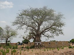
The Salaga market served as a transit point through the northern Sahel and the southernmost coast of the 'Sahel', as well as through the Dagomba towns of Kpabia and Yendi. This gave rise to the transport of cattle and groundnuts from Yendi via the Salaga market. [5] It also was the transit point through which kola was transported from modern day Ghana to northern Nigeria. During the Trans-Atlantic slave trade, Salaga also served as an important market from where slaves were transported to the coast for export. In Salaga, there is a pond named "Wonkan bawa," which is a Huasa phrase that means "the bathing spot of slaves." There is also a young Baobab tree in the area that was formerly the Slave Market. [8] This is why a market in Jamestown is called the "Salaga Market": slaves originally shipped from the Salaga slave market were sold there.

In 1892, civil war broke out in Salaga, resulting in a mass exodus of mostly Zongo peoples out of the area.

Notable people

Related Research Articles

<span class="mw-page-title-main">Dagaaba people</span> Ethnic group in West Africa

The Dagaaba people are an ethnic group located north of the convergence of Ghana, Burkina Faso and Côte d'Ivoire. They speak the Dagaare language, a Gur language made up of the related Northern Dagaare dialects, Southern Dagaare dialects and a number of sub dialects. In northern dialects, both the language and the people are referred to as Dagara. They are related to the Birifor people and the Dagaare Diola. The language is collectively known as Dagaare, and historically some non-natives have taken this as the name of the people. One historian, describing the former usage of "Dagarti" to refer to this community by colonials, writes: "The name 'Dagarti' appears to have been coined by the first Europeans to visit the region, from the vernacular root dagaa. Correctly 'Dagari' is the name of the language, 'Dagaaba' or 'Dagara' that of the people, and 'Dagaw' or 'Dagawie' that of the land."

<span class="mw-page-title-main">Tamale, Ghana</span> Major City in Northern Region, Ghana

Tamale, officially called Tamale Metropolitan Area is the capital city of the Northern Region of Ghana. Tamale is Ghana's third largest city. It has a projected population of 950,124 according to the Tamale Metropolitan Assembly Official Website. It is the fastest-growing city in West Africa. It is located 600 km (370 mi) north of Accra. Most residents of Tamale are Muslims and Dagombas by tribe, as reflected by the multitude of mosques in Tamale, most notably the Central Mosque, Afa Ajura Mosque, Afa Basha mosque and The Ahmadiyyah Muslim mission Mosque.

Yaa Naa Yakubu Andani II was the King of Dagbon, the traditional kingdom of the Dagomba people in northern Ghana, from 31 May 1974 until his assassination on 27 March 2002. He was born in August 1945 in Sagnarigu, a suburb of Tamale in the Northern Region of Ghana. Yakubu II was killed on 27 March 2002 at Yendi, the capital of the Kingdom of Dagbon, by unknown people when clashes broke out between the two feuding Gates of Dagbon Kingship. For 600 years the Abudu and Andani clans, named after two sons of the ancient Dagbon king Ya Naa Yakubu I, cordially rotated control of the kingdom centred in Yendi, 530 kilometres (330 mi) north of Accra, the capital of Ghana. As of January 2014, a regent has acted as sovereign of the kingdom until 18 January 2019 when a new ruler is chosen to occupy the revered Lion Skins of Yendi.

The Dagombas or Dagbamba are a Gur ethnic group of northern Ghana, numbering more than 3.1 million people. The term Dagbamba is also used to refer to other descendants of Naa Gbewaa including the Mamprusi and Nanumba. They inhabit the Northern Region of Ghana in the Guinea savanna region. They speak the Dagbani language which belongs to the Mole-Dagbani sub-group of the Gur languages. There are more than 3 million native speakers of Dagbani. The Dagomba are historically related to the Mossi people. The Mossi Kingdoms were founded by Yennenga, a daughter of the founder of the Dagbon Kingdom, Naa Gbewaa. The Mohi/Mossi now have their homeland in central present-day Burkina Faso. Aside the Mossi, the Dagombas are the progenitors of the Bouna state of Ivory Coast, and the Dagaaba states of Upper West Region of Ghana. The homeland of the Dagomba is called Dagbon and now covers about 20,000 km2 in area.

The Dyula are a Mande ethnic group inhabiting several West African countries, including Mali, Cote d'Ivoire, Ghana, and Burkina Faso.

Gonja was a kingdom in northern Ghana founded in 1675 by Sumaila Ndewura Jakpa. The word can also refer to the people of this kingdom.

The Wangara are a subgroup of the Soninke who later became assimilated merchant classes that specialized in both Trans Saharan and Secret Trade of Gold Dust. Their diaspora operated all throughout West Africa Sahel-Sudan. Fostering regionally organized trade networks and Architecture projects. But based in the many Sahelian and Niger-Volta-Sene-Gambia river city-states. Particularly Dia, Timbuktu, Agadez, Kano, Gao, Koumbi Saleh, Guidimaka, Salaga, Kong, Bussa, Bissa, Kankan, Jallon, Djenné as well as Bambouk, Bure, Lobi, and Bono State goldfields and Borgu. They also were practicing Muslims with a clerical social class (Karamogo), Timbuktu Alumni political advisors, Sufi Mystic healers and individual leaders (Marabout). Living by a philosophy of merchantile pacifism called the Suwarian Tradition. Teaching peaceful coexistence with non-Muslims, reserving Jihad for self-defence only and even serving as Soothsayers or a "priesthood" of literate messengers for non-Muslim Chiefdoms/Kingdoms. This gave them a degree of control and immense wealth in lands where they were the minority. Creating contacts with almost all West African religious denominations. A group of Mande traders, loosely associated with the Kingdoms of the Sahel region and other West African Empires. Such as Ghana, Mali, Songhai, Bono State, Kong, Borgu, Dendi, Macina, Hausa Kingdoms & the Pashalik of Timbuktu. Wangara also describes any land south of Timbuktu and Agadez. The Bilad-Al-Sudan or Bilad-Al-Tibr, "Land of Black" or "Gold."

The Guan languages are languages of the Kwa language family spoken by the Guan people in Ghana and Togo:

<span class="mw-page-title-main">Yendi Municipal District</span> Municipal District in Northern, Ghana

Yendi Municipal District is one of the sixteen districts in Northern Region, Ghana. Originally created as an ordinary district assembly in 1988 when it was known as Yendi District, which was created from the former East Dagomba District Council, until it was elevated to municipal district assembly status on 29 February 2008 to become Yendi Municipal District; However on 28 June 2012, the western part of the district was later split off to create Mion District; thus the remaining part has been retained as Yendi Municipal District. The municipality is located in the central part of Northern Region and has Yendi as its capital town.

Bimbilla is the capital town of Nanumba North District, a district in the Northern Region of Ghana. It is located in the East of the region, and is near the Oti River.

<span class="mw-page-title-main">Zongo settlements</span> Areas in West African towns

Zongo settlements are areas in West African towns populated mostly by migrants from the northern savannah regions and the West African Sahel, especially from northern Nigeria.

<span class="mw-page-title-main">Kingdom of Dagbon</span> Traditional Empire of Dagbon and Kingdom of the Dagomba people in Ghana

The Kingdom of Dagbon (Dagbaŋ) is one of the oldest and most organised traditional kingdoms in Ghana founded by the Dagomba people (Dagbamba) in the 15th century. During its rise, it comprised, at various points, the Northern, Upper West, Upper East, Savannah Region and North East regions of present-day Ghana. It also covered portions of Burkina Faso, North East Ivory Coast and North West Togo. Since Ghana's independence in 1957, the Kingdom just like all of Ghana's kingdoms and ethnic states has assumed a traditional, customary role.

<span class="mw-page-title-main">Mion District</span> District in Northern region, Ghana

Mion District is one of the sixteen districts in Northern Region, Ghana. Originally it was formerly part of the then-larger Yendi District in 1988, which was created from the former East Dagomba District Council, until the western part of the district was later split off to create Mion District on 28 June 2012; thus the remaining original part has bee retained to become Yendi Municipal District. The district assembly is located in the central part of Northern Region and has Sang as its capital town.

The 1892 Sack of Salaga was a Gonja civil war for the control of the town of Salaga that occurred on December 5, 1892. A rebellion led by Kabachewura Isifa and assisted by his Dagomba and Nanumba allies overthrew Kpembewura Napo who died in exile in the same year.

The Zabarma Emirate was an Islamic state that existed from the 1860s to 1897 in what is today parts of Ghana and Burkina Faso.

Ndewura Jakpa was an African king, founder of a dynasty in Gonja, in the early 17th century.

<span class="mw-page-title-main">Savannah Region</span> Region of Ghana

The Savannah Region is one of the newest regions of Ghana and yet the largest region in the country. The creation of the Region follows presentation of a petition by the Gonja Traditional Council, led by the Yagbonwura Tumtumba Boresa Jakpa I. Upon receiving favourable responses from all stakeholders in the Northern Region, the Brobbey Commission, a referendum was conducted on the 27th December 2018. The result was a resounding yes of 99.7%. The President of the Republic of Ghana signed and presented the Constitutional Instrument (CI) 115 to the Yagbonwura in the Jubilee House, Accra on 12 February 2019. The launch was well attended by sons and daughters of Gonjaland including all current and past Mps, MDCEs and all appointees with Gonjaland descent. Damongo was declared the capital of the new Savannah Region. It is located in the north of the country. The Savannah Region is divided into 7 districts; Bole, Central Gonja, North Gonja, East Gonja, Sawla/Tuna/Kalba, West Gonja, North East Gonja and 7 Constituencies; Bole/Bamboi, Damongo, Daboya/Mankarigu, Salaga North, Salaga South, Sawla/Tuna/Kalba and Yapei/Kusawgu. The capital of Bole district is Bole; East Gonja municipal is Salaga; West Gonja district is Damango; Sawla Tuna Kalba district is Salwa; Central Gonja is Buipe; North Gonja is Daboya; and North East Gonja is Kpalbe

Salaga Slave Market is an 18th-century slave market located in the East Gonja District of northern Ghana. During the Trans-Atlantic slave trade, Salaga served as an important market where slaves were transported to the coast for export. The market also served as outposts for the movement of slaves along the trans-Saharan routes.

Kpalbe or Palbe is a town in the Savannah Region of Ghana. It is the capital of the North East Gonja District.

8 roads with several sub routes were built by the Ashanti Empire to connect the capital with cities north and south of the empire starting from the 18th century. Ashanti roads were supervised and policed by the government, but the sacred roads of the state received more attention. 4 main roads were directed northwards of the state whiles the other 4 were built south and towards the Coast. The southern roads of the Ashanti Empire fell into decline in the late 19th century and the entire road network was abandoned following British colonization.

References

  1. 1 2 "World Gazetteer online". World-gazetteer.com. Archived from the original on September 30, 2007.
  2. East Gonja district
  3. "MP redeems campaign pledge in donating brand new motorcycles - MyJoyOnline.com". www.myjoyonline.com. Retrieved 2021-05-20.
  4. "Salaga Slave Market; A potential tourist site". Graphic Online. Retrieved 2023-01-28.
  5. 1 2 The Evolution of War: A Study of Its Role in Early Societies By Maurice R. Davie
  6. Salaga slave market. books.google.com.
  7. copied Wilks, Ivor. "'He Was With Them': Malam Abu On The Zaberma Of The Middle Volta Basin." Sudanic Africa 4 (1993): 213-22.
  8. "Salaga | About Ghana". ghana.peacefmonline.com. Retrieved 2023-01-28.

Further reading

Coordinates: 8°33′N0°31′W / 8.550°N 0.517°W / 8.550; -0.517