
Thurston County is a county located in the U.S. state of Washington. As of the 2020 census, its population was 294,793. The county seat and largest city is Olympia, the state capital.
The Zhongsha Islands is a Chinese term for a collection of two skerries, many entirely submerged banks, seamounts, and shoals in the South China Sea. There are in fact, no islands in the Macclesfield Bank, the main part of Zhongsha. The Scarborough Shoal, which consists of two skerries, is not contiguous with the Macclesfield Bank but Chinese sources treat them as one chain of geographical features. The whole of the region is claimed by both the PRC and the ROC, and various bits of the eastern parts are claimed by the Philippines. No country has constant control of the whole region, and there are disputes - for example, see Scarborough Shoal standoff.
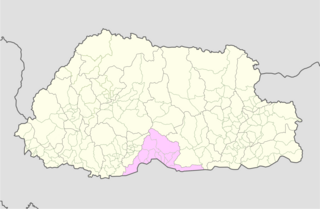
Sarpang District is one of the 20 dzongkhags (districts) comprising Bhutan. Sarpang covers a total area of 1,946 km2 (751 sq mi) and stretches from Lhamoizhingkha in West Bhutan to Manas National Park in the east. Sarpang Dzongkhag is divided into one dungkhag, Gelephu, and 12 gewogs.

The Wilder Institute/Calgary Zoo is located in Bridgeland, Calgary, Alberta, Canada, just east of the city's downtown and adjacent to the Inglewood and East Village neighborhoods. It is accessible via Calgary's C-Train light rail system, by car via Memorial Drive, and by bicycle and footpath via the Bow River pathway. A large portion of the zoo is located on St. George's Island in the Bow River.
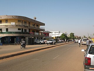
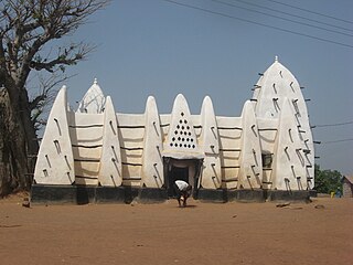
Wa is the capital town of Wa Municipal and Upper West Region of northern Ghana. It forms part of the eleven Municipalities and Districts that make-up the Upper West Region. It’s Municipal Assembly is one of the 261 Metropolitan, Municipal and District Assemblies (MMDAs) in Ghana.

The Upper West Region of Ghana is located in the north-western corner of Ghana and is bordered by Upper East Region to the east, Northern Region to the south, and Burkina Faso to the west and north. The Upper West regional capital and largest settlement is Wa. The Upper West was created by the then Head of State, Flight-Lieutenant Jerry Rawlings in 1983 under the Provisional National Defense Council (PNDC) military regime. The area was carved out of the former Upper Region, which is now the Upper East Region. For about thirty-five years, it remained the youngest region of Ghana until 2018 when six more regions were created by the Nana Addo Dankwa Akufo-Addo government; hence increasing the total number of administrative regions in the country to sixteen.

Arusha Region is one of Tanzania's 31 administrative regions and is located in the northeast of the country. The region's capital and largest city is the city of Arusha. The region is bordered by Kajiado County and Narok County in Kenya to the north, the Kilimanjaro Region to the east, the Manyara and Singida Regions to the south, and the Mara and Simiyu regions to the west. Arusha Region is home to Ngorongoro Conservation Area, a UNESCO World Heritage Site. The region is comparable in size to the combined land and water areas of the state of Maryland in the United States.

Humla District, a part of Karnali Province, is one of the seventy-seven districts of Nepal. The district, with Simikot as its district headquarters, covers an area of 5,655 km2 (2,183 sq mi) and has population of 50,858 as per the census of 2011. Namkha is the largest rural municipal which lies in humla Humla is the 2nd largest district of Nepal. The southern and middle parts of Humla District are inhabited by Khas communities, originating from Sinja valley, whereas the higher and northern parts of Humla are mostly inhabited by culturally Tibetan communities.

Nizamabad district is a district located in the north-western region of the Indian state of Telangana. The city of Nizamabad is the district headquarters. The district share boundaries with Jagtial, Sircilla, Nirmal, Kamareddy districts and with Nanded district of the state boundary of Maharashtra.

The Ningaloo Coast is a World Heritage Site located in the north west coastal region of Western Australia. The 705,015-hectare (1,742,130-acre) heritage-listed area is located approximately 1,200 kilometres (750 mi) north of Perth, along the East Indian Ocean. The distinctive Ningaloo Reef that fringes the Ningaloo Coast is 260 kilometres (160 mi) long and is Australia's largest fringing coral reef and the only large reef positioned very close to a landmass. The Muiron Islands and Cape Farquhar are within this coastal zone.

The Dr Kenneth Kaunda District Municipality, formerly the Southern District Municipality, is one of the 4 districts of the North West province of South Africa. The seat of the municipality is Klerksdorp. As of 2016, a plurality of its 742,821 residents speak Setswana. The majority of its residents live in the City of Matlosana. The district code is DC40. The district was formerly known as the Southern District Municipality. It is named after Kenneth Kaunda, the first President of Zambia.

The Sekhukhune District Municipality is one of the 5 districts of the Limpopo province of South Africa. The seat is Groblersdal. As of 2011, the majority of its 1,076,840 inhabitants spoke Sepedi. The district code is DC47.
Chapleau is a provincial electoral district in the Outaouais region of Quebec, Canada that elects members to the National Assembly of Quebec. It is located within the city of Gatineau.
Milestone is a town in southeast Saskatchewan, Canada, on Saskatchewan Highway 39. The town was named after C. W. Milestone in 1893. The town serves as a service centre for the neighbouring countryside with the area's economy dominated by agriculture.
Qozdərə is a village in the Tovuz District of Azerbaijan. The village forms part of the municipality of Məşədilər.
Empire Bede was a 6,959 GRT cargo ship which was built by G M Harland & Wolff Ltd, Glasgow in 1942 for the Ministry of War Transport (MoWT). She had a short career, being damaged by a torpedo and then sunk by gunfire on 18 August 1942.

Southcrest is an urban community in the southeastern section of the city of San Diego. It is bordered by Mountain View on the north and east, Interstate 5 and the neighborhoods of Barrio Logan and Logan Heights on the west, and Shelltown on the south. Major thoroughfares include National Avenue and 40th Street.
Yatala is a former electorate of the South Australian House of Assembly located within the cadastral Hundred of Yatala. It was one of the original Assembly districts in 1857, abolished in 1902.
Washington's 17th legislative district is one of forty-nine districts in Washington state for representation in the state legislature.
The Savannah Region is one of the newest regions of Ghana and yet the largest region in the country. The creation of the Region follows presentation of a petition by the Gonja Traditional Council, led by the Yagbonwura Tumtumba Boresa Jakpa I. Upon receiving favourable responses from all stakeholders in the Northern Region, the Brobbey Commission, a referendum was conducted on the 27th December 2018. The result was a resounding yes of 99.7%. The President of the Republic of Ghana signed and presented the Constitutional Instrument (CI) 115 to the Yagbonwura in the Jubilee House, Accra on 12 February 2019. The launch was well attended by sons and daughters of Gonjaland including all current and past Mps, MDCEs and all appointees with Gonjaland descent. Damongo was declared the capital of the new Savannah Region. It is located in the north of the country. The Savannah Region is divided into 7 districts; Bole, Central Gonja, North Gonja, East Gonja, Sawla/Tuna/Kalba, West Gonja, North East Gonja and 7 Constituencies; Bole/Bamboi, Damongo, Daboya/Mankarigu, Salaga North, Salaga South, Sawla/Tuna/Kalba and Yapei/Kusawgu. The capital of Bole district is Bole; East Gonja municipal is Salaga; West Gonja district is Damango; Sawla Tuna Kalba district is Salwa; Central Gonja is Buipe; North Gonja is Daboya; and North East Gonja is Kpalbe

