Wa, Ghana

Last updated

Wa
Town
Wa main street (Ghana) 3.JPG
View of a high street in Wa
Etymology: Dagbani: Wa ("te wa kaa yeng seore", English: "we came to watch a dance") [1]
Ghana adm location map.svg
Red pog.svg
Wa
Location of Wa in Upper West Region
Coordinates: 10°4′N2°30′W / 10.067°N 2.500°W / 10.067; -2.500
Country Ghana
Region Upper West Region
District Wa Municipal District
Elevation
305 m (1,001 ft)
Population
 (2021)
  Total200,672 [2]
Time zone GMT
  Summer (DST) GMT
Postal code
XW
Area code 039
Website wamunicipal.gov.gh OOjs UI icon edit-ltr-progressive.svg

Wa is a town and the capital of the Wa Municipal District and the Upper West Region of Ghana. [3] It has a population of 200,672 people according to the 2021 census. [4] [5]

Contents

The town is a transportation hub for the Upper West region, with major roads leading north to Hamile, and northeast to Tumu and the Upper East Region. There is also a small airport, named the Wa Airport. [6]

History

Etymology

Wa is a Dagbani word meaning te wa kaa yeng seore ('we came to watch a dance'). [1]

Formation

The Lobis were originally the first settlers of the area (now Wa). It grew into an important center of trade due to being situated near the Black Volta. The town was also where most of the Wala Kingdom was situated in.

Under the Northern Protectorates, the town experienced slow infrastructure development due to neglection by the colonial administration. [7]

Administration

Wa has a mayor–council form of government. The mayor is appointed/approved by the town council, the Wa Municipal Assembly. The current mayor of Wa is Hon. Tahiru Issahaku Moomin. [8]

Economy

Despite its urban status, Wa is in many ways still an agricultural community with the majority of the town's population engaged in small scale farming. Main crops grown include corn, millet, yams, okra and groundnuts. The town also grows cash crops, which include soya beans, and groundnuts, bambara beans. [9] [5]

Demographics

Historical population
YearPop.±%
19212,806    
193113,025+364.2%
194814,406+10.6%
197013,740−4.6%
198436,067+162.5%
200066,644+84.8%
2010125,479+88.3%
Source: Ghana Statistical Service. [10] [7] [11] [12]

In 1880, it was estimated that Wa had about 8,000 people. This number is thought to have fallen to 2,000 by 1900. In the 1921 census, the population of the town was 2,806. The population had risen to 5,207 by 1931. In that same year, the Wa district, which was now a part of the Wala Native Authority had a population of 13,025. In 1948, Wa had a population of 14,406 while the district had 15,827 people. In 1960 the population was 14,406. In 1970 the population had risen to 13,740. [10] [7] In the 2000 census, the town's population was 66,644 while in the 2010 census the population was 125,479. [11] [12]

Islam is the largest religion in the town making up 65.9% of the population. This is followed by Christianity (29%), traditionalists (4.1%), and other religions (0.4%). [5] Major ethic groups who resided in Wa include the Wala, the Sisaala, and the Dagaaba. [13]

Transportation

There is public transport from Wa to major cities such as Accra; Kumasi, Mim, Ahafo; Cape Coast, Sunyani; Tamale; Tema; Ho; Bolgatanga; Elubo; Aflao, and Techiman. [5]

Geography

A plant in Wa Jahan 1 -Wa.jpg
A plant in Wa

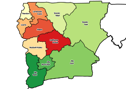
Wa is located in the north-western part of Ghana. It has a size that covers a total land area of 579.86 km2 (223.89 sq mi). The average land height of the town sits between 160 mm (0.52 ft) and 300 mm (0.98 ft) above sea level. [7] The municipal share surrounding borders Daffiama-Bussie-Issa District to the north-west, Nadowli-Kaleo District to the north-east, Wa East District to the east and to the west and south the Wa West District. [5]

Climate

Wa has a tropical savanna climate (Köppen climate classification Aw), with a wet season and a dry season and the temperature being hot year-round. The wet season usually occurs between March to July while the dry season can happen from September to November. The mean maximum temperatures can range from 34–40 °C (93–104 °F) whilst the mean minimum temperatures can reach 29 °C (84 °F). The average monthly relative humidity stands around 40.67%. [14]

Climate data for Wa
MonthJanFebMarAprMayJunJulAugSepOctNovDecYear
Record high °C (°F)38.9
(102.0)
40.0
(104.0)
41.7
(107.1)
41.7
(107.1)
39.4
(102.9)
37.2
(99.0)
33.9
(93.0)
34.1
(93.4)
34.4
(93.9)
36.7
(98.1)
38.9
(102.0)
38.0
(100.4)
41.7
(107.1)
Mean daily maximum °C (°F)34.4
(93.9)
35.9
(96.6)
36.1
(97.0)
34.8
(94.6)
32.8
(91.0)
30.5
(86.9)
29.1
(84.4)
28.8
(83.8)
29.5
(85.1)
32.4
(90.3)
34.5
(94.1)
33.8
(92.8)
32.7
(90.9)
Daily mean °C (°F)26.9
(80.4)
29.1
(84.4)
30.0
(86.0)
29.1
(84.4)
27.8
(82.0)
26.1
(79.0)
25.0
(77.0)
24.5
(76.1)
24.7
(76.5)
26.5
(79.7)
27.5
(81.5)
26.7
(80.1)
27.0
(80.6)
Mean daily minimum °C (°F)19.4
(66.9)
21.7
(71.1)
23.7
(74.7)
24.0
(75.2)
23.1
(73.6)
22.0
(71.6)
21.6
(70.9)
21.3
(70.3)
21.2
(70.2)
21.6
(70.9)
21.2
(70.2)
19.4
(66.9)
21.7
(71.1)
Record low °C (°F)12.8
(55.0)
15.6
(60.1)
18.9
(66.0)
18.9
(66.0)
18.9
(66.0)
19.6
(67.3)
18.9
(66.0)
18.3
(64.9)
18.9
(66.0)
18.9
(66.0)
17.2
(63.0)
12.2
(54.0)
12.2
(54.0)
Average precipitation mm (inches)3
(0.1)
14
(0.6)
41
(1.6)
94
(3.7)
131
(5.2)
139
(5.5)
149
(5.9)
192
(7.6)
215
(8.5)
81
(3.2)
17
(0.7)
6
(0.2)
1,082
(42.6)
Average precipitation days (≥ 0.3 mm)1248101213161872192
Average relative humidity (%) (at 15:00)16182844556366696851331944
Mean monthly sunshine hours 285.2265.6266.6225.0266.6228.0207.7176.7189.0285.2279.0297.62,972.2
Mean daily sunshine hours 9.29.48.67.58.67.66.75.76.39.29.39.68.1
Source: Deutscher Wetterdienst [15]

Culture

Front view of Wa Naa's Palace Palace Pillas (2).jpg
Front view of Wa Naa's Palace

The Wa Naa's Palace, located in Wa, is home to chief (Wa Naa) of the Wala people. Cattle is a symbol of wealth in the town and is sometimes used for marriage payment. [16]

Festivals

The Damba festival is an annual event celebrated in the town and throughout Northern Ghana. It is typically held in late September. [17] The Dumba festival is another annual event celebrated in the town. It is usually celebrated in the month of September or October. [18]

Cuisine

Human resources

Health

Birdseye-view of Wa regional hospital Wa regional hospital.jpg
Birdseye-view of Wa regional hospital

Wa has a total of 26 health facilities, including community health planning services and four private facilities. [7] The largest hospital in the town is the Wa regional hostipal. It is a 160-bed facility that opened in 2019 with a project cost of GH₵5,254,500,000 (US$339 million). [19]

Education

The town is the educational hub of the region. University for Development Studies, Nusrat Jahan Ahmadiyya College of Education and Wa Polytechnic have branches or are located in Wa. [7] The Wa Technical University, formerly Wa Polytechnic, was establish in 1999 and begin program offerings in 2004. There are currently 600 students enrolled in the institution. [20]

The following is a list of educational institutions in Wa: [21]

Senior high schools
Colleges/Universities

Notable People

Siita Sofo Hissan [22]

Wiyaala

Samini

Mohammed Kudus

Abdul-Rashid Pelpuo

Salma Mumin

Abdul Haye Mumin

Shamima Muslim

See also

Related Research Articles

<span class="mw-page-title-main">Dagaaba people</span> Ethnic group in West Africa

The Dagaaba people are an ethnic group located north of the convergence of Ghana, Burkina Faso and Côte d'Ivoire. They speak the Dagaare language, a Gur language made up of the related Northern Dagaare dialects, Southern Dagaare dialects and a number of sub dialects. In northern dialects, both the language and the people are referred to as Dagara. They are related to the Birifor people and the Dagaare Diola. The language is collectively known as Dagaare, and historically some non-natives have taken this as the name of the people. One historian, describing the former usage of "Dagarti" to refer to this community by colonials, writes: "The name 'Dagarti' appears to have been coined by the first Europeans to visit the region, from the vernacular root dagaa. Correctly 'Dagaari' is the name of the language, 'Dagaaba' or 'Dagara' that of the people, and 'Dagaw' or 'Dagawie' that of the land."

<span class="mw-page-title-main">Kumasi</span> City in Ashanti Region, Ghana

Kumasi is a city in the Ashanti Region, and is among the largest metropolitan areas in Ghana. Kumasi is located in a rain forest region near Lake Bosomtwe, and is the commercial, industrial, and cultural capital of the historical Ashanti Empire. Kumasi is approximately 500 kilometres (300 mi) north of the Equator and 200 kilometres (100 mi) north of the Gulf of Guinea. Kumasi is alternatively known as "The Garden City" because of its many species of flowers and plants in the past. It is also called Oseikrom, after Osei Kofi Tutu I who was a king in the Ashanti empire.

<span class="mw-page-title-main">Tamale, Ghana</span> City in Northern Region, Ghana

Tamale is the capital city of the Northern Region of Ghana. It is Ghana's third largest city, with a population of 371,351 people. The city has been ranked as the fastest-growing city in West Africa. Tamale is located in the Kingdom of Dagbon, Ghana's oldest Kingdom. Major ethnic groups who resided in Tamale are Dagomba, Gonja, Mamprusi, Akan, and Dagaaba.

<span class="mw-page-title-main">Sekondi-Takoradi</span> City in Western Region, Ghana

Sekondi-Takoradi is a city in Ghana comprising the twin cities of Sekondi and Takoradi. It is the capital of Sekondi-Takoradi Metropolitan District and the Western Region of Ghana. Sekondi-Takoradi is the region's largest city as well as an industrial and commercial center with a population of 104,847 people, according to the 2021 census.

<span class="mw-page-title-main">Bolgatanga</span> Town in Upper East Region, Ghana

Bolgatanga, colloquially known as Bolga, is a town and the capital of the Bolgatanga Municipal and the Upper East Region of Ghana, adjacent to the border with Burkina Faso. Bolgatanga is 161 km (100 mi) to the north of Tamale. The town lies in the Red Volta Valley, with the White Volta and the cliffs of the Gambaga escarpment to the south of the town forming the southern boundary of the Upper East Region. As of 2012, the town has a population of about 66,685 people. Some ethnic groups who lived in large qualities in Bolgatanga are Northerners, Akan, Ewe, and Ga-Adangbe. The current mayor of the town is Rex Asanga.

<span class="mw-page-title-main">Islam in Ghana</span> Ethnic group

Islam was the first Abrahamic monotheistic religion to arrive in Ghana. Today, it is the second most widely professed religion in the country behind Christianity. Its presence in Ghana dates back to the 10th century. According to the Ghana Statistical Service's Population and Housing census (2021), the percentage of Muslims in Ghana is about 19.9%.

<span class="mw-page-title-main">Upper West Region</span> Region of Ghana

The Upper West Region of Ghana is located in the north-western corner of Ghana and is bordered by Upper East Region to the east, Northern Region to the south, and Burkina Faso to the west and north. The Upper West regional capital and largest settlement is Wa. The Upper West was created by the then Head of State, Jerry Rawlings in 1983 under the Provisional National Defence Council (PNDC) military regime. The area was carved out of the former Upper Region, which is now the Upper East Region. For about thirty-five years, it remained the youngest region of Ghana until 2018 when six more regions were created by the Nana Addo Dankwa Akufo-Addo government; hence increasing the total number of administrative regions in the country to sixteen.

<span class="mw-page-title-main">Upper East Region</span> Region of Ghana

The Upper East Region is located in northern part of Ghana and it is the third smallest of the 16 administrative regions in Ghana. It occupies a total land surface of 8,842 square kilometers or 2.7% of the total land area of Ghana. The regional capital is Bolgatanga, which is sometimes referred to as Bolga. Other major towns in the region include Navrongo, Paga, Sandema, Bawku, and Zebilla, Tempane, Pusiga, Garu, Pwalugu, Widana

<span class="mw-page-title-main">Greater Accra Region</span> Region of Ghana

The Greater Accra Region has the smallest area of Ghana's 16 administrative regions, occupying a total land surface of 3,245 square kilometres. This is 1.4 per cent of the total land area of Ghana. It is the most populated region, with a population of 5,455,692 in 2021, accounting for 17.7 per cent of Ghana's total population.

<span class="mw-page-title-main">West Mamprusi Municipal Assembly</span> District in North East region, Ghana

West Mamprusi Municipal Assembly is one of the six districts in North East Region, Ghana. Originally created as an ordinary district assembly in 1988 when it was known as West Mamprusi District, which was created from the former Mamprusi District Council, until the western part of the district was split off on 28 June 2012 to create Mamprugu-Moagduri District; thus the remaining part has been retained as West Mamprusi District. However, on 15 March 2018, it was elevated to municipal district assembly status to become West Mamprusi Municipal District. The municipality is located in the western part of North East Region and has Walewale as its capital town. Other settlements within the municipal assembly include Wulugu.

<span class="mw-page-title-main">Bawku Municipal District</span> Municipal district in Upper East region, Ghana

Bawku Municipal District is one of the fifteen districts in Upper East Region, Ghana. Originally created as an ordinary district assembly in 1988 when it was known as Bawku East District; which was established by Legislative Instrument (L.I.) 1439, until the southern part of the district was split off by a decree of president John Agyekum Kufuor in August 2004 to create Garu-Tempane District; thus the remaining part was elevated to municipal district assembly status on the same year to become Bawku Municipal District. However, on 28 June 2012, two parts of the district were later split off to create Binduri District and Pusiga District respectively; thus the remaining part has been retained as Bawku Municipal District. The municipality is located in the eastern part of Upper East Region and has Bawku as its capital town.

The Wala or Waala live in Upper West Region of Ghana. They are a predominantly Muslim people who are the founders of the city of Wa and the Kingdom of Wala. They speak the Wali language, which belongs to the Gur group. There are 84,800 speakers of the language as of 2013. Their neighbors are the Birifor, Dagaaba, and Vagla peoples.

Mampong is a town and the capital of the Mampong Municipal in the Ashanti Region of Ghana. As of 2012, the town has a population of 42,037 people. The town is home to the Mamponghene, Nana Osei Bonsu II.

<span class="mw-page-title-main">Damongo</span> Regional Capital of Savannah Region, Ghana

Damongo is a town and the capital of West Gonja Municipal. It was declared the capital of the Savannah Region on 12 February, 2019. Damongo is home to Bikunuto Jewu Soale I, the paramount chief of the Gonja Kingdom. The languages spoken in Damongo include Gonja, Vagla, Hanga, Dagaare, Waale, Frafra, Kasim, Twi, Ewe, and Hausa. Damongo is renowned for hosting the prestigious Yagbon Skin.

<span class="mw-page-title-main">Funsi</span> District Capital in Upper West Region, Ghana

Funsi is the district capital of the Wa East District in the Upper West Region of north Ghana.

<span class="mw-page-title-main">Ahmadiyya in Ghana</span> Islamic movement

The Ahmadiyya Muslim Community is the second largest group of Islam in Ghana after Sunni Islam. The early rise of the Community in Ghana can be traced through a sequence of events beginning roughly at the same time as the birth of the Ahmadiyya movement in 1889 in British India. It was during the early period of the Second Caliphate that the first missionary, Abdul Rahim Nayyar was sent to what was then the Gold Coast in 1921 upon invitation from Sunni Muslims in Saltpond. Having established the movement in the country, Nayyar left and was replaced by the first permanent missionary, Al Hajj Fadl-ul-Rahman Hakim in 1922.

Nasa is a village in Ghana in the historic Kingdom of Wala in the current Upper West Region of Ghana. It is 14 miles northeast of Wa, Ghana.

Dumba Festival is an annual festival celebrated by the chiefs and people of Wa of the Wala Paramouncy in the Upper West Region of Ghana. It is usually celebrated in the month of September or October.

<span class="mw-page-title-main">Siita Sofo Hissan</span>

Siita Sofo Hissan(born March 8, 1983) is Ghanaian banker, entrepreneur, media mogul, author and philanthropist. He is the founding President of AfCFTA Young Entrepreneurs Federation (AfYEF), a Pan-African organisation which aims at facilitating growth, trade, networking and empowerment for youth-led businesses across Africa.

References

Citations

  1. 1 2 Awedoba 2009, p. 47.
  2. Population of Regions and Districts (PDF) (Report). Ghana Statistical Service. November 2021.
  3. "Campaign on effective handling of food items held in Wa". Graphic Online. Retrieved 20 May 2021.
  4. "Ghana Districts: A repository of all Local Assemblies in Ghana". GhanaDistricts. Retrieved 23 August 2023.
  5. 1 2 3 4 5 "2010 Population and Housing Census - Wa Municipal" (PDF). Ghana Statistical Service. Retrieved 20 July 2024.
  6. Touring Ghana – Upper West Region. touringghana.
  7. 1 2 3 4 5 6 Ahmed, A.; Korah, P.; Dongzagla, A.; Nunbogu, A.; Niminga-Beka, R.; Kuusaana, E.; Abubakari, Z. (2020). "City profile: Wa, Ghana". Cities. 97 102524. doi:10.1016/j.cities.2019.102524 . Retrieved 19 July 2024.
  8. "Upper West Regional Peace Council". National Peace Council, Ghana. Retrieved 11 August 2024.
  9. Naazie, G.; Agyemang, I.; Tampah-Naah, A. (2024). "Characterization of urban agriculture and farmers' climate change adaptation: the case of Urban Wa, Ghana". Discover Sustainability. 5 (58). Bibcode:2024DiSus...5...58N. doi:10.1007/s43621-024-00227-0 . Retrieved 20 July 2024. ...The Wa Municipality has about 200,672 residents with 143,358 urban dwellers. Also, out of about 70% who engage in agricultural activities, only 30.2% are direct food crops...
  10. 1 2 Wilks 2002, pp. 11–13.
  11. 1 2 "2000 population & housing census - special report on urban localities". Ghana Statistical Service. Retrieved 20 July 2024.
  12. 1 2 "Population of Regions and Districts Report (2010)" (PDF). Ghana Statistical Service. p. 107. Retrieved 12 July 2024.
  13. Awedoba 2009, p. 39.
  14. Bessah, E.; Amponsah, W.; Ansah, S.; Afrifa, A.; Yahaya, B.; Wemegah, C.; Tanu, M.; Amekudzi, L.; Agyare, W. (2022). "Climatic zoning of Ghana using selected meteorological variables for the period 1976–2018". Meteorological Applications. 29 (1): 2049. Bibcode:2022MeApp..29.2049B. doi: 10.1002/met.2049 .
  15. "Klimatafel von Wa / Ghana" (PDF). Baseline climate means (1961-1990) from stations all over the world (in German). Deutscher Wetterdienst. Retrieved 18 October 2016.
  16. Wilks 2002, pp. 5–7.
  17. "Damba as a festival and dance form". Arts Ghana. 11 July 2014. Retrieved 6 March 2021.
  18. "At the peak of Dumba Festival". Graphic Online. Retrieved 27 August 2020.
  19. "Nana Addo commissions Upper West Regional Hospital". Citi Newsroom. 18 August 2019. Retrieved 22 July 2024.
  20. "Where's Wa?". Saskatchewan Polytechnic. Retrieved 22 July 2024.
  21. "Senior High Schools in Upper West Region of Ghana". schoolsingh.com. Archived from the original on 6 May 2024.
  22. "Siita Sofo Hissan", Wikipedia, 24 August 2024, retrieved 24 August 2024

Bibliography

  • Awedoba, A. K. (2009). An Ethnographic Study of Northern Ghanaian Conflicts. Sub-Saharan Publishers. ISBN   9789988647384.
  • Wilks, Ivor (4 July 2002). Brown, Carolyn; Anderson, David (eds.). Wa and the Wala: Islam and Polity in Northwestern Ghana. Cambridge University Press. ISBN   9780521894340.