Bolgatanga, colloquially known as Bolga, is a town and the capital of the Bolgatanga Municipal District and Upper East Region of Ghana, adjacent to the border with Burkina Faso. Bolgatanga has over 2012 settlement and a population of about 66,685 people. Bolgatanga is 161 km to the north of Tamale. Bolgatanga lies in the Red Volta River Valley, with the White Volta River and the cliffs of the Gambaga Escarpment to the south of the town forming the southern boundary of the Upper East Region.

The Upper West Region of Ghana is located in the north-western corner of Ghana and is bordered by Upper East region to the east, Northern region to the south, and Burkina Faso to the west and north. The Upper West regional capital and largest settlement is Wa. The Upper West was created by the then Head of State, Flight-Lieutenant Jerry Rawlings in 1983 under the Provisional National Defense Council (PNDC) military regime. The area was carved out of the former Upper Region, which is now the Upper East Region. For about thirty-five years, it remained the youngest region of Ghana until 2018 when six more regions were created by the Nana Addo Dankwa Akufo-Addo government; hence increasing the total number of administrative regions in the country to sixteen.

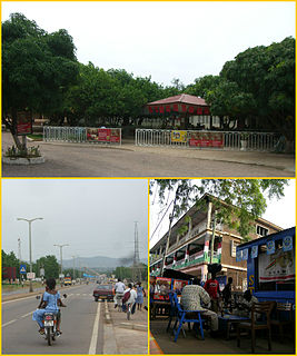
Tumu is a small town and is the capital of Sissala East district, a district in the Upper West Region of north Ghana, adjacent to the border with Burkina Faso. Tumu is connected by road to the town of Navrongo.

Jirapa/Lambussie District is a former district that was located in Upper West Region, Ghana. Originally created as an ordinary district assembly in 1988. However on 29 February 2008, it was split off into two new districts: Jirapa Municipal District and Lambussie-Karni District. The district assembly was located in the northwest part of Upper West Region and had Jirapa as its capital town.
West Mamprusi Municipal Assembly is one of the six districts in North East Region, Ghana. Originally created as an ordinary district assembly in 1988 when it was known as West Mamprusi District, which was created from the former Mamprusi District Council, until the western part of the district was split off on 28 June 2012 to create Mamprugu-Moagduri District; thus the remaining part has been retained as West Mamprusi District. However on 15 March 2018, it was elevated to municipal district assembly status to become West Mamprusi Municipal District. The municipality is located in the western part of North East Region and has Walewale as its capital town. Other settlements within the municipal assembly include Wulugu.

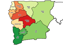
Sissala East Municipal District is one of the eleven districts in Upper West Region, Ghana. Originally it was formerly part of the then-larger Sissala District in 1988; until the western part of the district was later split off to create Sissala West District on July 2004; thus the remaining part has been renamed as Sissala East District, which it was later elevated to municipal district assembly status on 15 March 2018 to become Sissala East Municipal District. The municipality is located in the northeast/eastern part of Upper West Region and has Tumu as its capital town.
Sissala West District is one of the eleven districts in Upper West Region, Ghana. Originally it was formerly part of the then-larger Sissala District in 1988; until the western part of the district was later split off to create Sissala West District in July 2004; thus the remaining part has been renamed as Sissala East District. The district assembly is located in the northern/northeast part of Upper West Region and has Gwollu as its capital town.
Wa Municipal District is one of the eleven districts in Upper West Region, Ghana. Originally created as an ordinary district assembly in 1988 when it was known as Wa District, until two parts of the district were later split off by a decree of president John Agyekum Kufuor on July 2004 to create Wa East District and Wa West District respectively; thus the remaining part was later elevated to municipal district assembly status on the same year to become Wa Municipal District. The municipality is located in the southern part of Upper West Region and has Wa as its capital town, which also serves as the regional capital of the Upper West Region.
Wa West District is one of the eleven districts in Upper West Region, Ghana. Originally it was formerly part of the then-larger Wa District in 1988; until two parts of the district were later split off to create Wa East District and Wa West District respectively on July 2004; thus the remaining part was elevated to municipal district assembly status on the same year to become Wa Municipal District. The district assembly is located in the southern part of Upper West Region and has Wechiau as its capital town.
Pudo is a town in Sissala East Municipal District, Upper West Region in northern Ghana near the border with Burkina Faso.

Sissala West is one of the constituencies represented in the Parliament of Ghana. It elects one Member of Parliament (MP) by the first past the post system of election. Sissala West is located in the Sissala West district of the Upper West Region of Ghana.
Sissala East is one of the constituencies represented in the Parliament of Ghana. It elects one Member of Parliament (MP) by the first past the post system of election. Sissala East is located in the Sissala East Municipal of the Upper West Region of Ghana.
Wa Central is one of the constituencies represented in the Parliament of Ghana. It elects one Member of Parliament (MP) by the first past the post system of election. Wa Central is located in the Wa Municipal district of the Upper West Region of Ghana.
Wa East is one of the constituencies represented in the Parliament of Ghana. It elects one Member of Parliament (MP) by the first past the post system of election. Wa East is located in the Wa East District of the Upper West Region of Ghana.

The Ghana Health Service (GHS) is a Ghanaian government body established in 1996 as part of the Health Sector Reform of Ghana. The Health Service is under the Ministry of Health. The Health service primarily administrates the health services provided by the government and in implementing government policies on healthcare.
Lambussie Karni District is one of the eleven districts in Upper West Region, Ghana. Originally it was formerly part of the then-larger Jirapa/Lambussie District in 1988; until the northern part of the district was later split off to create Lambussie-Karni District on 29 February 2008; thus the remaining part has been renamed as Jirapa District. The district assembly is located in the northwest part of Upper West Region and has Lambussie as its capital town.

Upper Denkyira West District is one of the twenty-two districts in Central Region, Ghana. Originally it was formerly part of the then-larger Upper Denkyira District in 1988, which was created from the former Denkyira District Council, until the northwest part of the district was split off to create Upper Denkyira West District on 29 February 2008; thus the remaining part has been renamed as Upper Denkyira East District. The district assembly is located in the northwest part of Central Region and has Diaso as its capital town.
Mohammed Adams Sukparu is a Ghanaian politician who is a member of the National Democratic Congress. He is the member of Parliament for the Sissala West Constituency in the Upper West Region.
Sissala District is a former district that was located in Upper West Region, Ghana. Originally created as an ordinary district assembly in 1988. However on July 2004, it was split off into two new districts: Sissala East District and Sissala West District. The district assembly was located in the northeast part of Upper West Region and had Tumu as its capital town.
Jirapa Municipal District is one of the eleven districts in Upper West Region, Ghana. Originally it was formerly part of the then-larger Jirapa/Lambussie District in 1988; until the northern part of the district was later split off to create Lambussie-Karni District on 29 February 2008; thus the remaining part has been renamed as Jirapa District, which it was later elevated to municipal district assembly status on 15 March 2018 to become Jirapa Municipal District. The municipality is located in the northwest part of Upper West Region and has Jirapa as its capital town.