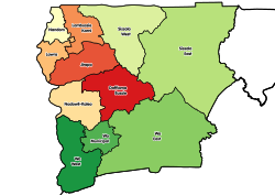
Gwollu Gwolu | |
---|---|
District Capital | |
Location of Gwollu in Upper West region | |
Coordinates: 10°58′52″N2°13′16″W / 10.98111°N 2.22111°W | |
Country | Ghana |
Region | Upper West Region |
District | Sissala West District |
Elevation | 1,191 ft (363 m) |
Population (2010) | |
• Total | 4,854 |
Time zone | UTC0 (UTC) |
Gwollu is a small town and is the capital of Sissala West district, a district in the Upper West Region of north Ghana. [1] Hilla Limann, a former Ghanaian president was born and raised here.
The town contains several tourist attractions such as the tomb of Ghana's president Dr. Hilla Limann, [2] a traditional bone setter's center and a slave defense wall. [3] The wall was built in the 19th century as a double circle by Gwollu Koro Limann as a defense against slave raiders. [4]
Hilla Limann, was a Ghanaian diplomat and politician who served the President of Ghana from 24 September 1979 to 31 December 1981. He served as a diplomat in Lomé, Togo and Geneva, Switzerland.
The Upper West Region of Ghana is located in the north-western corner of Ghana and is bordered by Upper East Region to the east, Northern Region to the south, and Burkina Faso to the west and north. The Upper West regional capital and largest settlement is Wa. The Upper West was created by the then Head of State, Flight-Lieutenant Jerry Rawlings in 1983 under the Provisional National Defence Council (PNDC) military regime. The area was carved out of the former Upper Region, which is now the Upper East Region. For about thirty-five years, it remained the youngest region of Ghana until 2018 when six more regions were created by the Nana Addo Dankwa Akufo-Addo government; hence increasing the total number of administrative regions in the country to sixteen.
The People's National Convention is a political party in Ghana. After constitutional rule was restored back in Ghana in 1992 the party was formed by former President Hilla Limann based on ideals from the People's National Party which he led in the 1979 elections and won.
Tumu is a small town and is the capital of Sissala East district, a district in the Upper West Region of north Ghana, adjacent to the border with Burkina Faso. The Municipality has the population of 80,619 with 39,868 males and 40,751 females according to 2021 population and housing census. The town consists mainly of the Sissala by tribe. Tumu is connected by road to the town of Navrongo.
Jirapa/Lambussie District is a former district that was located in Upper West Region, Ghana. Originally created as an ordinary district assembly in 1988. However on 29 February 2008, it was split off into two new districts: Jirapa Municipal District and Lambussie-Karni District. The district assembly was located in the northwest part of Upper West Region and had Jirapa as its capital town.
West Mamprusi Municipal Assembly is one of the six districts in North East Region, Ghana. Originally created as an ordinary district assembly in 1988 when it was known as West Mamprusi District, which was created from the former Mamprusi District Council, until the western part of the district was split off on 28 June 2012 to create Mamprugu-Moagduri District; thus the remaining part has been retained as West Mamprusi District. However, on 15 March 2018, it was elevated to municipal district assembly status to become West Mamprusi Municipal District. The municipality is located in the western part of North East Region and has Walewale as its capital town. Other settlements within the municipal assembly include Wulugu.
Sissala East Municipal District is one of the eleven districts in Upper West Region, Ghana. Originally it was formerly part of the then-larger Sissala District in 1988; until the western part of the district was later split off to create Sissala West District in July 2004; thus the remaining part has been renamed as Sissala East District, which it was later elevated to municipal district assembly status on 15 March 2018 to become Sissala East Municipal District. The municipality is located in the northeast/eastern part of Upper West Region and has Tumu as its capital town.
Sissala West District is one of the eleven districts in Upper West Region, Ghana. Originally it was formerly part of the then-larger Sissala District in 1988; until the western part of the district was later split off to create Sissala West District in July 2004; thus the remaining part has been renamed as Sissala East District. The district assembly is located in the northern/northeast part of Upper West Region and has Gwollu as its capital town.
Wa East District is one of the eleven districts in Upper West Region, Ghana. Originally it was formerly part of the then-larger Wa District in 1988; until two parts of the district were later split off to create Wa East District and Wa West District respectively in July 2004; thus the remaining part was elevated to municipal district assembly status in the same year to become Wa Municipal District. The district assembly is located in the southern part of Upper West Region and has Funsi as its capital town.
Lambussie Karni District is one of the eleven districts in Upper West Region, Ghana. Originally it was formerly part of the then-larger Jirapa/Lambussie District in 1988; until the northern part of the district was later split off to create Lambussie-Karni District on 29 February 2008; thus the remaining part has been renamed as Jirapa District. The district assembly is located in the northwest part of Upper West Region and has Lambussie as its capital town.
Ghana gained independence from the British on 6 March 1957. It is a member of the Commonwealth of Nations. The country became a republic on July 1, 1960.
1998 in Ghana details events of note that happened in Ghana in 1998.
1970s in Ghana details events of note that happened in Ghana in the years 1970 to 1979.
1980s in Ghana details events of note that happened in Ghana in the years 1980 to 1989.
Nalerigu is the largest town in the East Mamprusi Municipal. It is home to the paramount chief (NaYiri) of the Mamprusis. With the addition of 6 new regions in 2018, Nalerigu was declared the capital of the North East Region of Ghana.
Emmanuel Adama Mahama was a Ghanaian politician. He served as a Member of Parliament during the First Republic of Ghana. He is the father of John Dramani Mahama, the 4th President of the 4th Republic of Ghana.
The Gwollu Defence Wall is a historic wall in the Upper West Region of Ghana. The wall is located near the Burkina Faso-Mali border. It was built as a defense against slave traders.
Sissala District is a former district that was located in Upper West Region, Ghana. Originally created as an ordinary district assembly in 1988. However, in July 2004, it was split off into two new districts: Sissala East District and Sissala West District. The district assembly was located in the northeast part of Upper West Region and had Tumu as its capital town.
Jirapa Municipal District is one of the eleven districts in the Upper West Region Ghana. Originally it was formerly part of the then-larger Jirapa/Lambussie District in 1988; until the northern part of the district was later split off to create Lambussie-Karni District on 29 February 2008; that is, the remaining part has been renamed as Jirapa District, which was later elevated to municipal district assembly status on 15 March 2018 to become Jirapa Municipal District. The municipality is located in the northwest parts of the Upper West Region and has Jirapa as its capital town.
Fulera Limann was a First Lady in the third republic of Ghana as the wife of the late Hilla Limann.