Upper West Region

Last updated
Upper West Region
Our building structures.jpg
Ghana - Upper West.svg
Location of Upper West Region in Ghana
Country Ghana
Capital Wa
Districts11
Government
   Regional Minister Hafiz Bin Salih [1] [2]
Area
[3]
  Total18,476 km2 (7,134 sq mi)
  Rank Ranked 7th
Population
 (2021 census) [4]
  Total901,502
  Density49/km2 (130/sq mi)
GDP (PPP)
  Year2013
  Per capita$5,150
GDP (Nominal)
  Year2013
  Per capita$2,500
Time zone GMT
Area code 039
ISO 3166 code GH-UW
HDI (2017)0.518 [5]
low · 9th

The Upper West Region of Ghana is located in the north-western corner of Ghana [6] and is bordered by Upper East Region to the east, Northern Region to the south, and Burkina Faso to the west and north. The Upper West regional capital and largest settlement is Wa. The Upper West was created by the then Head of State, Flight-Lieutenant Jerry Rawlings in 1983 under the Provisional National Defense Council (PNDC) military regime. The area was carved out of the former Upper Region, which is now the Upper East Region. For about thirty-five years, it remained the youngest region of Ghana until 2018 when six more regions were created by the Nana Addo Dankwa Akufo-Addo government; hence increasing the total number of administrative regions in the country to sixteen.

Contents

Geography and climate

Location and size

The Upper West Region is one of the 16 regions of Ghana. It is located at the North Western corner of Ghana with latitude 9.8°- 11.O° North and longitude 1.6°- 3.0 West, bounded by Burkina Faso to the North. It covers a geographical area of 18,476 square kilometers, representing 12.7% of the total land area of Ghana. The northern Ghana-Burkina Faso is bordered on the east by the Upper East region and Northern regions, on the south by the Northern region, on the west by western Ghana-Burkina Faso, and the Upper West region on the north. It is the seventh largest region in Ghana in total area, and it is made up of 11 districts. By virtue of its location, the Upper West Region has the potential for international and inter-regional trade and other bilateral relations, but the overspill of criminal activities and disasters, such as bushfires, diseases and pestilence, armed robbery, etc., from the region's neighbors also pose a threat. [7]

Tourism

The Wechiau Hippopotamus Sanctuary is located southwest of Wa, along the Black Volta River in the Wa West District. The Gwollu Wall in the Sissala District serves as the hometown of one of Ghana's past presidents - Dr. Hilla Limann. [8]

Cuisine

The staple food of the people of the Upper West Region is sao or Tuo Zaafi in the local dialect, which is often abbreviated TZ or T-Zed in English. [9]

Economy

The major economic activity of the Upper West Region is agriculture. Crops grown include corn, millet, peanuts, okra, shea tree, and rice. Sheep, goats, chickens, pigs and guinea fowl are raised for meat and eggs. Because the region's dry season is long, extending roughly from October to May, many people leave the region to work in the southern part of Ghana for at least part of the year.

Sports

Schools

Some popular schools in the region include St. Francis Xavier Junior Seminary, St. Francis Girls of Assis, St. Michael Boys - Nandom, St. Ignatius of Loyola SHS, Queen of Peace SHS, lawra Senior High School, Kanton Senior High School, Wa Senior High School, Wa Senior High Technical School, Wa UDS, Jirapa Nursing Training College, Jahan Training College, Wa Technical University, etc...}}

Administrative divisions

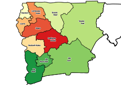
The political administration of the region is through the local government system. Under this administration system, the region is divided into 11 MMDA's (made up of 0 Metropolitan, 5 Municipal and 6 Ordinary Assemblies). [10] Each District, Municipal or Metropolitan Assembly, is administered by a Chief Executive, representing the central government but deriving authority from an Assembly headed by a presiding member elected from among the members themselves. The current list is as follows:

Districts of the Upper West Region Districts of the Upper West Region (2012).svg
Districts of the Upper West Region
Districts of the Upper West Region [11]
#MMDA NameCapitalMMDA TypePopulation
1 Daffiama-Bussie-Issa Issa Ordinary
2 Jirapa Jirapa Municipal
3 Lambussie-Karni Lambussie Ordinary
4 Lawra Lawra Municipal
5 Nadowli-Kaleo Nadowli Ordinary
6 Nandom Nandom Municipal
7 Sissala East Tumu Municipal
8 Sissala West Gwollu Ordinary
9 Wa East Funsi Ordinary
10 Wa Municipal [12] Wa Municipal
11 Wa West Wechiau Ordinary

Notable natives

Prominent and famous citizens of Upper West Region include:

Festivals of the Upper West Region

Festivals that take place in the Upper West Region include: [13]

Related Research Articles

<span class="mw-page-title-main">Hilla Limann</span> Ghanaian diplomat and politician

Hilla Limann, was a Ghanaian diplomat and politician who served the President of Ghana from 24 September 1979 to 31 December 1981. He served as a diplomat in Lomé, Togo and Geneva, Switzerland.

<span class="mw-page-title-main">Jirapa/Lambussie District</span> Former District in Upper West region, Ghana

Jirapa/Lambussie District is a former district that was located in Upper West Region, Ghana. Originally created as an ordinary district assembly in 1988. However on 29 February 2008, it was split off into two new districts: Jirapa Municipal District and Lambussie-Karni District. The district assembly was located in the northwest part of Upper West Region and had Jirapa as its capital town.

<span class="mw-page-title-main">Lawra Municipal District</span> Municipal District in Upper West region, Ghana

Lawra Municipal is one of the eleven districts in the Upper West Region of Ghana. Originally, it was formerly part of the then-larger Lawra District in 1988, until the northern part of the district was later split off to create Nandom District on June 28, 2012; thus, the remaining part has remained as Lawra District, which was later elevated to municipal assembly status on March 15, 2018 to become Lawra Municipal Assembly. The municipality is located in the northwest part of the Upper West Region and has Lawra as its capital town.

<span class="mw-page-title-main">Sissala West District</span> District in Upper West, Ghana

Sissala West District is one of the eleven districts in Upper West Region, Ghana. Originally it was formerly part of the then-larger Sissala District in 1988; until the western part of the district was later split off to create Sissala West District in July 2004; thus the remaining part has been renamed as Sissala East District. The district assembly is located in the northern/northeast part of Upper West Region and has Gwollu as its capital town.

Sisaala (Sissala) is a Gur language cluster spoken in northern Ghana near the town of Tumu and in the neighbouring republic of Burkina Faso. Western Sisaala is intermediate between Sisaali and Tumulung Sisaala.

<span class="mw-page-title-main">Sissala West (Ghana parliament constituency)</span> Constituency in Ghana

Sissala West is one of the constituencies represented in the Parliament of Ghana. It elects one Member of Parliament (MP) by the first past the post system of election. Sissala West is located in the Sissala West district of the Upper West Region of Ghana.

<span class="mw-page-title-main">Sissala East (Ghana parliament constituency)</span> Constituency in Ghana

Sissala East is one of the constituencies represented in the Parliament of Ghana. It elects one Member of Parliament (MP) by the first past the post system of election. Sissala East is located in the Sissala East Municipal of the Upper West Region of Ghana.

<span class="mw-page-title-main">Lawra-Nandom (Ghana parliament constituency)</span> Constituency in Ghana

Lawra-Nandom is one of the constituencies represented in the Parliament of Ghana. It elects one Member of Parliament (MP) by the first past the post system of election. Lawra-Nandom is located in the Lawra district of the Upper West Region of Ghana.

Benjamin Bewa-Nyog Kunbuor was the Ghanaian Minister for Defence of the Ghanaian Ministry of Defence and a Ghanaian politician. He was the Member of Parliament for the Nandom constituency.

<span class="mw-page-title-main">Jirapa, Ghana</span> Town in Upper West Region, Ghana

Jirapa is the capital town of the Jirapa Municipal in the Upper West Region of Ghana.

<span class="mw-page-title-main">Ghana Health Service</span>

The Ghana Health Service (GHS) is a Ghanaian government body established in 1996 as part of the Health Sector Reform of Ghana. The Health Service is under the Ministry of Health. The Health service primarily administrates the health services provided by the government and in implementing government policies on healthcare. The Director-General of the Health service is Dr. Patrick Kuma-Aboagye.

<span class="mw-page-title-main">Lambussie-Karni District</span> District in Upper West, Ghana

Lambussie Karni District is one of the eleven districts in Upper West Region, Ghana. Originally it was formerly part of the then-larger Jirapa/Lambussie District in 1988; until the northern part of the district was later split off to create Lambussie-Karni District on 29 February 2008; thus the remaining part has been renamed as Jirapa District. The district assembly is located in the northwest part of Upper West Region and has Lambussie as its capital town.

Gwollu is a small town and is the capital of Sissala West district, a district in the Upper West Region of north Ghana. Hilla Limann, a former Ghanaian president was born and raised here.

Nandom is the capital town of the Nandom Municipal of the Upper West Region of Ghana.

<span class="mw-page-title-main">Bede Ziedeng</span> Ghanaian politician

Bede Anwataazumo Ziedeng popularly known as Bede Ziedeng is a Ghanaian politician. In 2008, Bede Ziedeng contested the Lawra-Nandom Parliamentary election on the ticket of the Democratic Freedom Party. He lost to Hon. Ambrose Dery of the New Patriotic Party. Ziedeng served as the General Secretary of the Democratic Freedom Party (DFP) in 2006.

<span class="mw-page-title-main">Nandom Municipal District</span> Municipal District in Upper West, Ghana

Nandom Municipal is one of the eleven districts in Upper West Region, Ghana. Originally it was formerly part of the then-larger Lawra/Nandom District in 1988; until the northern part of the district was later split off to create Nandom District on 28 June 2012; thus the remaining part has been renamed as Lawra District. However on 27 January 2020, it was elevated to municipal assembly status to become Nandom Municipal Assembly. The municipality is located in the northwest part of Upper West Region and has Nandom as its capital town.

The N12 or National Highway 12 is a national highway in Ghana that begins at the Ghana - Côte d'Ivoire border in the Western Region of Ghana and travels generally north to Hamile on the Ghana - Burkina Faso border. Its total length is 670 kilometres.

<span class="mw-page-title-main">Jirapa Municipal District</span> Municipal District in Upper West, Ghana

Jirapa Municipal District is one of the eleven districts in the Upper West Region Ghana. Originally it was formerly part of the then-larger Jirapa/Lambussie District in 1988; until the northern part of the district was later split off to create Lambussie-Karni District on 29 February 2008; that is, the remaining part has been renamed as Jirapa District, which was later elevated to municipal district assembly status on 15 March 2018 to become Jirapa Municipal District. The municipality is located in the northwest parts of the Upper West Region and has Jirapa as its capital town.

The Gbele Resource Centre or Gbele Game Production Reserve is one of the lesser known game reserves in Ghana. It is located in the Sissala West, Sissala East Municipal and Daffiama Bussie Issa districts of the Upper West Region The reserve is the fourth largest in Ghana. The nearest town is Tumu, capital of the Sissala East Municipal District which is 17 kilometres to the north. A total of 176 species of birds have been recorded in the reserve. The staff in the reserve are aware of an additional 18 species. The reserve contains antelope, hartebeest, bushbuck, waterbuck, savannah duikers and warthogs, baboon, patas, green monkey among others. There are about 190 species of birds as well. There are nature hikes provided as well. About 30 kilometres to the north of the centre is the Gwollu Defence Wall.

<span class="mw-page-title-main">Daffiama-Bussie-Issa (Ghana parliament constituency)</span> An electoral constituency in Ghana

Daffiama-Bussie-Issa is one of the constituencies represented in the Parliament of Ghana. It elects one Member of Parliament (MP) by the first past the post system of election. Daffiama-Bussie-Issa is located in the Daffiama-Bussie-Issa District of the Upper West Region of Ghana.

References

  1. "Regional Ministers". Archived from the original on 2012-01-03.
  2. "Work to start on 670-km feeder roads in Upper West - Graphic Online". Archived from the original on 2021-05-20.
  3. "Upper West Region". GhanaDistricts.com. Retrieved 2009-11-20.
  4. "Ghana Statistical Services - Population by Regions, Upper West". statsghana.gov.gh. Retrieved 2021-02-01.
  5. "Sub-national HDI - Area Database - Global Data Lab". hdi.globaldatalab.org. Retrieved 2018-09-13.
  6. Boakye, Edna Agnes (2021-05-21). "Sissala West MP laments exclusion of Sissala areas from EU-funded road projects". Citinewsroom - Comprehensive News in Ghana. Retrieved 2021-05-21.
  7. GOG(MLGRD)
  8. ghanadistricts.com
  9. "Tuo zaafi | Traditional Side Dish From Northern Region | TasteAtlas". www.tasteatlas.com. Retrieved 2021-10-01.
  10. "Upper West". citypopulation.de. Retrieved 27 May 2021.
  11. Upper West Region – Districts
  12. "Contractors who do shoddy work to pay more for maintenance - Roads Minister warns - MyJoyOnline.com". www.myjoyonline.com. Retrieved 2021-05-20.
  13. "Upper West Region". touringghana.com. 2016-02-24. Retrieved 2020-01-28.

Sources

10°20′N2°15′W / 10.333°N 2.250°W / 10.333; -2.250