Related Research Articles

Axim is a coastal town and the capital of Nzema East Municipal district, a district in Western Region of South Ghana. Axim lies 64 kilometers west of the port city of Sekondi-Takoradi in the Western Region, west of Cape Three Points. Axim has a 2013 settlement population of 27,719 people.
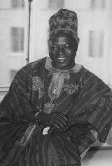
Hilla Limann, was a Ghanaian diplomat and politician who served the President of Ghana from 24 September 1979 to 31 December 1981. He served as a diplomat in Lomé, Togo and Geneva, Switzerland.

Elmina Castle was erected by the Portuguese in 1482 as Castelo de São Jorge da Mina, also known as Castelo da Mina or simply Mina, in present-day Elmina, Ghana, formerly the Gold Coast. It was the first trading post built on the Gulf of Guinea, and the oldest European building in existence south of the Sahara.

Cape Coast Castle is one of about forty "slave castles", or large commercial forts, built on the Gold Coast of West Africa by European traders. It was originally a Portuguese "feitoria" or trading post, established in 1555, which was named Cabo Corso.

The Upper West Region of Ghana is located in the north-western corner of Ghana and is bordered by Upper East Region to the east, Northern Region to the south, and Burkina Faso to the west and north. The Upper West regional capital and largest settlement is Wa. The Upper West was created by the then Head of State, Flight-Lieutenant Jerry Rawlings in 1983 under the Provisional National Defence Council (PNDC) military regime. The area was carved out of the former Upper Region, which is now the Upper East Region. For about thirty-five years, it remained the youngest region of Ghana until 2018 when six more regions were created by the Nana Addo Dankwa Akufo-Addo government; hence increasing the total number of administrative regions in the country to sixteen.

Bunce Island is an island in the Sierra Leone River. It is situated in Freetown Harbour, the estuary of the Rokel River and Port Loko Creek, about 20 miles upriver from Sierra Leone's capital city Freetown. The island measures about 1,650 feet by 350 feet and houses a castle that was built by the Royal Africa Company in c.1670. Tens of thousands of Africans were shipped from here to the North American colonies of South Carolina and Georgia to be forced into slavery, and are the ancestors of many African Americans of the United States.

The House of Slaves and its Door of No Return is a museum and memorial to the victims of the Atlantic slave trade on Gorée Island, 3 km off the coast of the city of Dakar, Senegal. Its museum, which was opened in 1962 and curated until Boubacar Joseph Ndiaye's death in 2009, is said to memorialise the final exit point of the slaves from Africa. While historians differ on how many African slaves were actually held in this building, as well as the relative importance of Gorée Island as a point on the Atlantic slave trade, visitors from Africa, Europe, and the Americas continue to make it an important place to remember the human toll of African slavery.

Fort Prinzenstein is a fort located at Keta, Ghana, which was used in the slave trade. Many such forts were built in Africa, but Prinzenstein is one of the few that lie east of the Volta River. Keta served as an open port until the Tema Harbour commenced its operation to the west in 1962. The fort has been designated a World Heritage Site because of its historical importance and testimony to the Atlantic slave trade.

Osu Castle is a castle located in Osu, Ghana, on the coast of the Gulf of Guinea in Africa.
The trade and pilgrimage routes of Ghana are located in the Bono, Bono East, Ahafo, Savannah, North East, Northern, and Upper East Regions of northern Ghana. The routes were used by Bono people, Mandé warriors, Islamic traders and missionaries.

Ada Foah is a town on the southeast coast of Ghana, where the Volta River meets the Atlantic Ocean. The town is located along the Volta River, off of the Accra-Aflao motorway. Known for palm-lined beaches and estuary islands, Ada Foah is also the capital of the Ada East District and the seat of the District Assembly.

Fort Amsterdam is a former slave fort in Abandze, Central region, Ghana. It was built by the English between 1638 and 1645 as Fort Cormantin or Fort Courmantyne, and was captured by admiral Michiel de Ruyter of the Dutch West India Company in 1665, in retaliation for the capture of several Dutch forts by the English Admiral Holmes in 1664. It was subsequently made part of the Dutch Gold Coast, and remained part of it until the fort was traded with the British in 1868. The Fort is located at Abandze, on the north-east of Cape Coast in the Mfantseman District of the Central Region of Ghana. Because of its testimony to European economic and colonial influence in West Africa and its historical importance in the Atlantic slave trade, the fort was inscribed on the UNESCO World Heritage List in 1979 along with other forts and castles in Ghana.

Nalerigu is the largest town in the East Mamprusi Municipal. It is home to the paramount chief (NaYiri) of the Mamprusis. With the addition of 6 new regions in 2018, Nalerigu was declared the capital of the North East Region of Ghana.
Gwollu is a small town and is the capital of Sissala West district, a district in the Upper West Region of north Ghana. Hilla Limann, a former Ghanaian president was born and raised here.

Paga Crocodile Pond is a sacred pond in Paga in the Upper East Region of Ghana, which is inhabited by West African crocodiles. Due to the friendliness of the reptiles, it has become popular among tourists and the pond is now reliant on tourism to ensure the population of crocodiles remain fed and healthy. It is also known as Chief's pond.

The Pikworo Slave camp was founded in 1704 and was active until 1845. It is located in Paga nania, about 3 kilometers west of Paga in the Upper East Region of Ghana. It was originally developed as a slave transit center where slaves were auctioned and later resold in the Salaga Slave market after walking about 150 km to the south. They are later moved to the coast for shipment.

Dondoli Mosque is a mosque built in the Sudanese architectural style in the village of Dondoli in Wa in the Upper West region in Ghana. It was named after the neighborhood the mosque is.
Wuriyanga Mosque is located in the Upper East region of Ghana, beyond Garu. It is located southeast of Bawku.
The Assin Manso Ancestral Slave River also called Nnonkonsuo or Donkor Nsuo (singular) was one of the slave markets for gathering indigenes during the trans-Atlantic slave trade. It is located in the Central Region of Ghana, forty (40) kilometers along the Cape Coast-Kumasi highway.

Economic history of Ghana details the economic situation of Ghana since pre-colonial times to date.
References
- ↑ "Gwollu Slave Trade Defence Wall". ghana.peacefmonline.com. Retrieved 11 August 2020.
- ↑ "Gwollu Slave Trade Defence Wall". Ghana-Net.com. Retrieved 11 August 2020.
- 1 2 "Gwollu Slave Defense Wall". The Hauns in Africa. 23 October 2018. Retrieved 11 August 2020.
- ↑ "Ghana Museums & Monuments Board". www.ghanamuseums.org. Retrieved 11 August 2020.
- ↑ "Gwollu Slave Trader Defence Wall – FIANDAD GHANA LIMITED". Archived from the original on 2 August 2021. Retrieved 11 August 2020.
- ↑ "Visit Ghana | UPPER WEST REGION". Visit Ghana. Retrieved 11 August 2020.
- ↑ Swanepoel, Natalie (2010). "Living with Heritage: The Potentials of and Pressures on the Heritage Landscape of Gwollu, Upper West Region, Ghana". Journal of Field Archaeology. 35 (4): 400–411. ISSN 0093-4690.
- ↑ "Slave Defense Wall". Afro Tourism. 22 July 2015. Retrieved 11 August 2020.[ permanent dead link ]
| | This article about a Ghanaian building or structure related topic is a stub. You can help Wikipedia by expanding it. |