
The Western region, located in south Ghana, spreads from the Ivory Coast in the west to the Central region in the east, includes the capital and large twin city of Sekondi-Takoradi on the coast, coastal Axim, and a hilly inland area including Elubo. It includes Ghana's southernmost location, Cape Three Points, where crude oil was discovered in commercial quantities in June 2007. The region covers an area of 13,842 km2, and had a population of 2,060,585 at the 2021 Census. It has a coastline that stretches from South Ghana's border with the Ivory Coast to the boundary with the Central region on the east.

Elmina is a town and the capital of the Komenda/Edina/Eguafo/Abirem District on the south coast of Ghana in the Central Region. It is situated on a bay on the Atlantic Ocean, 12.2 km (7.6 mi) west of Cape Coast. Elmina was the first European settlement in West Africa and it has a population of 33,576 people, as of 2013. The current Municipality chief of Elmina is Solomon Ebo Appiah.
Wa is a town and the capital of the Wa Municipal District and the Upper West Region of Ghana. It has a population of 200,672 people according to the 2021 census.
Enchi is a town located in the Western North Region of Ghana. It is the capital of the Aowin Municipality. Other major towns in the Municipality includes: Old and New Yakasi, Achimfo, Boinso, Jema, Omanpe, Sewum, Jensue, Yiwabra, Yiwabra Nkwanta, Nyankomam, Kwawu, Abochia, and Jomoro. The largest water body in the Municipality is the Tano river whose tributary, the Desue (Disue), flows through the township of Enchi.
Bekwai is a town and the capital of the Bekwai Municipal, a municipality in the Ashanti Region of Ghana. Bekwai is the seventy-ninth most populous settlement in Ghana, with a population of 7,267 people as of 2013. Bekwai and Bekwai Municipal are south of Kumasi and north of Obuasi. As of 2021, the mayor of the municipal is Hon. Kwaku Kyei Baffour.
Berekum, nicknamed "The Golden City", is a city and the capital of Berekum East Municipal in the Bono Region of Ghana. The city has a population of 62,364 as of 2012. The native language of the Berekum people is the Bono Twi. As of 2020, the Omanhene of the city is Daasebre Dr. Amankona Diawuo II.

Aflao is a border town in the Ketu South District in the Volta Region of Ghana on the border with Togo. Aflao is the twenty-eighth most populous settlement in Ghana, in terms of population, with a population of 66,546 people. The current municipal chief of Aflao is Hon. Maxwell Koffie Lugudor.

Jomoro Municipal District is one of the fourteen districts in Western Region, Ghana. Originally created as an ordinary district assembly in 1988 when it was known as Jomoro District, which was created from the former Nzema District Council, until it was later elevated to municipal district assembly status on 15 March 2018 to become Jomoro Municipal District. The municipality is located in the southwest part of Western Region and has Half Assini as its capital town.
Agogo is a town in the Asante Akim North Municipal District of the Ashanti Region of Ghana. Agogo is approximately 80 kilometers (50 mi) east of Kumasi, the capital of the Ashanti Region, and had a population of 28,271 in the 2000 census. Computer projections estimate that the 2007 population was 32,859.

Wenchi is a town and the capital of Wenchi Municipal of the Bono Region in the middle-belt of Ghana. Wenchi is located at 7.73333 [latitude in decimal degrees], -2.1 [longitude in decimal degrees] at an average elevation/altitude of 304 meters. Wenchi is approximately 30 km north of Techiman and about 50 km east of the Ivory Coast border. Wenchi has a population of 39,187 people in 2013.
Juaben is a traditional town in the Juaben Municipality in the Ashanti Region of Ghana.
New Town is a village in the Jomoro district, a district in the Western Region of Ghana, adjacent to the border with Ivory Coast. The major highway that runs through the village is Half Assini - New Town Rd.
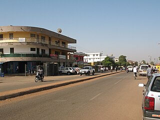
Half Assini, also known as Awiane, is a small town and is the capital of Jomoro Municipal District, a municipality in the Western Region of Ghana. It is the hometown of Kwame Nkrumah's father. Nkrumah, the first president of Ghana, had attended elementary school at Half Assini. The town is closer to the western border of Ghana, has white sand beaches and is known for its numerous tourist sites. One of Half Assini's chiefs, Anthony Kwaw, was best friends with Ghana's first president in school.
Sefwi Wiawso is a town in the Sefwi-Wiawso Municipal District in the Western North Region of Ghana. It doubles as the capital of Sefwi-Wiawso Municipal District and Western North Region. Wiawso serves as the traditional seat for the Omanhene of Sefwi-Wiawso Traditional Area. The settlement of Wiawso began on hilltop with Sefwi-Dwenase settlement occupying the lowlands. Overtime, Wiawso and Sefwi-Dwenase have conurbated with almost all the financial institutions, governmental agency-offices, lorry terminals and the main market all located in Sefwi Dwenase. Wiawso is known for producing timber, cocoa and cashew. One of Ghana's 261 Metropolitan, Municipal and District Assemblies (MMDAs), Sefwi Wiawso Municipal is a member of the 22 MMDAs in the Western North Region. Legislative Instrument (L.I) 1386, which was passed on November 23, 1988, formed the Municipality and designated Wiawso as its official capital. Based on the 2021 population and residential census, there are 151,220 people living in the Municipality, including 75,905 men and 75,315 women.
Banda Ahenkro is a town located in the west-northern of Bono region, Ghana, near the border of Ivory Coast. Its geography provided a home for numerous groups seeking shelter from across West Africa during the slave trade era. The original name of the settlement was Serminakuu meaning groups of 'grasses'. This name was changed to Banda, which is a corruption of 'Woanda' meaning 'they did not sleep'. Ancestors of Banda Ahenkro were allies of the Asante kingdom during wars and they provided a military force that virtually refused to sleep during at-war times. This is because they were predominantly Muslims and were found praying throughout the night. Later, 'woanda' was also corrupted by the Bono neighbours to become Banda. The settlement evolved to become the chief town or 'Ahenkro' within a collection of Nafana communities.
Amanokrom is a town in the Akuapim North District of the Eastern Region of Ghana. It shares border with Mamfe and Abotakyi

Kpone-Katamanso Municipal District is one of the twenty-nine districts in Greater Accra Region, Ghana. Originally it was part of the then-larger Tema Municipal District, which was created from the former Tema District Council, until the eastern portion of the district was split off to create Kpone-Katamanso District on 28 June 2012, which was established by Legislative Instrument (L.I.) 2031; thus the remaining part has been retained as Tema Metropolitan Assembly. However on 15 March 2018, it was later elevated to municipal district assembly status to become Kpone-Katamanso Municipal District, which was established by Legislative Instrument (L.I.) 2271. The municipality is located in the central part of Greater Accra Region and has Kpone as its capital town.

The Ghana–Ivory Coast border is 720 km in length and runs from the tripoint with Burkina Faso in the north to the Atlantic Ocean in the south.

Dorcas Affo-Toffey is a Ghanaian entrepreneur, philanthropist and politician. She is a member of the National Democratic Congress (NDC). She is the member of parliament for the Jomoro Constituency in the Western Region.
The N12 or National Highway 12 is a national highway in Ghana that begins at the Ghana - Côte d'Ivoire border in the Western Region of Ghana and travels generally north to Hamile on the Ghana - Burkina Faso border. Its total length is 670 kilometres.


