A county is a geographic region of a country used for administrative or other purposes in certain modern nations. The term is derived from the Old French comté denoting a jurisdiction under the sovereignty of a count (earl) or a viscount. Literal equivalents in other languages, derived from the equivalent of "count", are now seldom used officially, including comté, contea, contado, comtat, condado, Grafschaft, graafschap, and zhupa in Slavic languages; terms equivalent to commune/community are now often instead used.

Local government is a generic term for the lowest tiers of public administration within a particular sovereign state. This particular usage of the word government refers specifically to a level of administration that is both geographically localised and has limited powers. While in some countries, "government" is normally reserved purely for a national administration (government), the term local government is always used specifically in contrast to national government – as well as, in many cases, the activities of sub-national, first-level administrative divisions. Local governments generally act only within powers specifically delegated to them by law and/or directives of a higher level of government. In federal states, local government generally comprises a third or fourth tier of government, whereas in unitary states, local government usually occupies the second or third tier of government.

Accra is the capital and largest city of Ghana, located on the southern coast at the Gulf of Guinea, which is part of the Atlantic Ocean. As of 2021 census, the Accra Metropolitan District, 20.4 km2 (7.9 sq mi), had a population of 284,124 inhabitants, and the larger Greater Accra Region, 3,245 km2 (1,253 sq mi), had a population of 5,455,692 inhabitants. In common usage, the name "Accra" often refers to the territory of the Accra Metropolitan District as it existed before 2008, when it covered 199.4 km2 (77.0 sq mi). This territory has since been split into 13 local government districts: 12 independent municipal districts and the reduced Accra Metropolitan District (20.4 km2), which is the only district within the capital to be granted city status. This territory of 199.4 km2 contained 1,782,150 inhabitants at the 2021 census, and serves as the capital of Ghana, while the district under the jurisdiction of the Accra Metropolitan Assembly proper (20.4 km2) is distinguished from the rest of the capital as the "City of Accra".

A district is a type of administrative division that, in some countries, is managed by the local government. Across the world, areas known as "districts" vary greatly in size, spanning regions or counties, several municipalities, subdivisions of municipalities, school district, or political district.
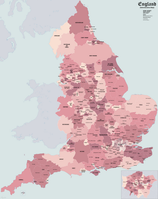
The subdivisions of England constitute a hierarchy of administrative divisions and non-administrative ceremonial areas.

The districts of England are a level of subnational division of England used for the purposes of local government. As the structure of local government in England is not uniform, there are currently four principal types of district-level subdivision. There are a total of 309 districts made up of 36 metropolitan boroughs, 32 London boroughs, 181 two-tier non-metropolitan districts and 58 unitary authorities, as well as the City of London and Isles of Scilly which are also districts, but do not correspond to any of these categories. Some districts are styled as cities, boroughs or royal boroughs; these are purely honorific titles and do not alter the status of the district or the powers of their councils. All boroughs and cities are led by a mayor who in most cases is a ceremonial figure elected by the district council, but—after local government reform—is occasionally a directly elected mayor who makes most of the policy decisions instead of the council.

The counties of England are areas used for different purposes, which include administrative, geographical, cultural and political demarcation. The term "county" is defined in several ways and can apply to similar or the same areas used by each of these demarcation structures. These different types of county each have a more formal name but are commonly referred to as just "counties". The current arrangement is the result of incremental reform.
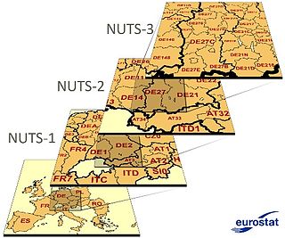
Nomenclature of Territorial Units for Statistics or NUTS is a geocode standard for referencing the administrative divisions of countries for statistical purposes. The standard, adopted in 2003, is developed and regulated by the European Union, and thus only covers the EU member states in detail. The Nomenclature of Territorial Units for Statistics is instrumental in the European Union's Structural Funds and Cohesion Fund delivery mechanisms and for locating the area where goods and services subject to European public procurement legislation are to be delivered.

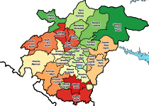
The Regions of Ghana constitute the first level of subnational government administration within the Republic of Ghana. As of 2020, there are currently sixteen regions, which are further divided for administrative purposes into 260 local metropolitan, municipal and district assemblies.
South Korea is made up of 17 first-tier administrative divisions: 6 metropolitan cities, 1 special city, 1 special self-governing city, and 9 provinces, including one special self-governing province. These are further subdivided into a variety of smaller entities, including cities, counties, districts, towns, townships, neighborhoods and villages.

Lithuania is divided into three layers of administrative divisions. The first-level division consists of 10 counties. These are sub-divided into 60 municipalities, which in turn are further sub-divided into over 500 smaller groups, known as elderships.

The administrative divisions of Ukraine are under the jurisdiction of the Ukrainian Constitution. Ukraine is a unitary state with three levels of administrative divisions: 27 regions, 136 raions and 1469 hromadas.

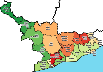
The Districts of Ghana are second-level administrative subdivisions of Ghana, below the level of region. There are currently 261 local metropolitan, municipal and district assemblies.
The administrative divisions of India are subnational administrative units of India; they are composed of a nested hierarchy of administrative divisions.
Thailand is a unitary state in Southeast Asia. The administrative services of the executive branch of the government are regulated by the National Government Organisation Act, BE 2534 (1991). Under this Act, the services are divided into three levels: central, provincial and local.

South Dayi District is one of the eighteen districts in Volta Region, Ghana. Originally it was formerly part of the then-larger Kpando District on 10 March 1989, until the southern part of the district was split off by a decree of president John Agyekum Kufuor on 19 August 2004 to create South Dayi District; thus the remaining part has been retained as Kpando District. The district assembly is located in the western part of Volta Region and has Kpeve as its capital town.
In South Australia, one of the states of Australia, there are many areas which are commonly known by regional names. Regions are areas that share similar characteristics. These characteristics may be natural such as the Murray River, the coastline, desert or mountains. Alternatively, the characteristics may be cultural, such as common land use. South Australia is divided by numerous sets of regional boundaries, based on different characteristics. In many cases boundaries defined by different agencies are coterminous.

La Dade Kotopon Municipal District is one of the twenty-nine districts in Greater Accra Region, Ghana. Originally it was formerly part of the then-larger Accra Metropolitan District in 1988, until the eastern portion of the district was split off to create La Dade Kotopon Municipal District on 28 June 2012; thus the remaining part has been retained as Accra Metropolitan District. The municipality is located in the central part of Greater Accra Region and has La as its capital town.