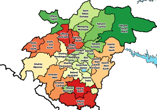
The Districts of Ghana are second-level administrative subdivisions of Ghana, below the level of region. There are currently 261 local metropolitan, municipal and district assemblies.
The Upper East Region is located in northern Ghana and is the third smallest of the 16 administrative regions in Ghana. It occupies a total land surface of 8,842 square kilometers or 2.7 per cent of the total land area of Ghana. The Upper East regional capital is Bolgatanga, sometimes referred to as Bolga. Other major towns in the region include Navrongo, Paga, Sandema, Bawku, and Zebilla.
Kumasi Metropolitan Assembly is one of the 261 Metropolitan, Municipal and District Assemblies (MMDAs) in Ghana. It forms part of the forty-three districts in Ashanti Region, Ghana with Kumasi being its administrative capital. The metropolis is located in the central part of Ashanti Region and has Kumasi as its capital city.With a projected population of over two million and an annual growth rate of about 5.4%, it is a rapidly expanding metropolis. The Metropolis is about 254 kilometers long, with a centrally located commercial area and a largely circular physical structure.The fast rate of urbanization is confirmed by estimates that 48%, 46%, and 60% of the Metropolis are rural, peri-urban, and urban, respectively.
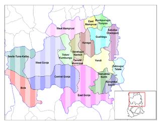
Tolon-Kumbungu District is a former district that was located in Northern Region, Ghana. Originally created as an ordinary district assembly in 1988, which was created from the former West Dagomba District Council. However on 28 June 2012, it was split out into two new districts: Tolon District and Kumbungu District. The district assembly was located in the central part of Northern Region and had Tolon as its capital town.

West Mamprusi Municipal Assembly is one of the six districts in North East Region, Ghana. Originally created as an ordinary district assembly in 1988 when it was known as West Mamprusi District, which was created from the former Mamprusi District Council, until the western part of the district was split off on 28 June 2012 to create Mamprugu-Moagduri District; thus the remaining part has been retained as West Mamprusi District. However, on 15 March 2018, it was elevated to municipal district assembly status to become West Mamprusi Municipal District. The municipality is located in the western part of North East Region and has Walewale as its capital town. Other settlements within the municipal assembly include Wulugu.

Garu District is one of the 15 districts in Upper East Region, Ghana. Originally it was formerly part of the then-larger Garu-Tempane District in 2004. The southeast part of the district was split off to create Tempane District on 15 February 2018 and the remaining part has been renamed as Garu District. The district assembly is located in the eastern part of Upper East Region. Its administrative capital is Garu.

Sunyani West District is one of the twelve districts in Bono Region, Ghana. Originally it was formerly part of the then-larger Sunyani District on 10 March 1989; until the northwest part of the district was split off to create Sunyani West District on 1 November 2007 ; thus the remaining part has been retained as Sunyani District. The district assembly is located in the western part of Bono Region and has Odumase as its capital town.
Sekyere Afram Plains District is one of the forty-three districts in Ashanti Region, Ghana. Originally it was formerly part of the then-larger Sekyere East District, which was created from the former Sekyere District Council. Later, a large portion of the district was split off to create the 1st Sekyere Afram Plains District on 1 November 2007, with Kumawu as its capital town. However, on 28 June 2012, the Afram Plains area of the district was split off to create the new Sekyere Afram Plains District, with Dobrosno as its capital town; while the remaining part has since then been officially renamed as Sekyere Kumawu District, with Kumawu as its capital town. The district assembly is located in the eastern part of Ashanti Region and has Drobosno as its capital town.
Kintampo North Municipal District is one of the eleven districts in Bono East Region, Ghana. Originally it was formerly part of the then-larger Kintampo District on 10 March 1989, until the southern part of the district was split off to create Kintampo South District on 12 November 2003 ; thus the remaining part has been renamed as Kintampo North District, which it was later elevated to municipal district assembly status on 1 November 2007 to become Kintampo North Municipal District. The municipality is located in the northern part of Bono East Region and has Kintampo as its capital town. As at 2021, Isaac Baffoe Ameyaw was the Municipal Chief Executive of the Assembly after he was nominated by Nana Akuffo-Addo.
Sefwi Wiawso is a town in the Sefwi-Wiawso Municipal District in the Western North Region of Ghana. It doubles as the capital of Sefwi-Wiawso Municipal District and Western North Region. Wiawso serves as the traditional seat for the Omanhene of Sefwi-Wiawso traditional area. The settlement of Wiawso began on hilltop with Sefwi-Dwenase settlement occupying the lowlands. Overtime, Wiawso and Sefwi-Dwenase have conurbated with almost all the financial institutions, governmental agency-offices, lorry terminals and the main market all located in Sefwi Dwenase. Wiawso is known for producing timber, cocoa and cashew. One of Ghana's 261 Metropolitan, Municipal and District Assemblies (MMDAs), Sefwi Wiawso Municipal is a member of the 22 MMDAs in the Western North Region. Legislative Instrument (L.I) 1386, which was passed on November 23, 1988, formed the Municipality and designated Wiawso as its official capital. Based on the 2021 population and residential census, there are 151,220 people living in the Municipality, including 75,905 men and 75,315 women.
Kumbungu is a town in the Kumbungu District of the Northern Region of Ghana. Kumbungu is the capital of Kumbungu district. As of 2010, fertility rate in Kumbungu stood at 3.6 and had a total population of 39,341 with an almost equal ratio of females to males. Kumbungu has a market center that comes off every sixth day.

Kumbungu District is one of the sixteen districts in Northern Region, Ghana. The district assembly is located in the northwest part of Northern Region and has Kumbungu as its capital town.
Mamprugu-Moagduri District is one of the six districts in North East Region, Ghana. Originally it was formerly part of a then-larger West Mamprusi District in 1988, which was created from the former Mamprusi District Council, until the western part of the district was split off on 28 June 2012 to create Mamprugu-Moagduri District; thus the remaining part was still has been retained West Mamprusi District. The district assembly is located in the western part of North East Region and has Yagaba as its capital town.
Sagnarigu Municipal is one of the sixteen districts in Northern Region, Ghana. Originally it was formerly part of the then-larger Tamale Municipal District in 1988, which was created from the former West Dagomba District Council, until a small northern part of the district was split off to create Sagnarigu District on 24 June 2012; thus the remaining part has been retained as Tamale Metropolitan District. However, on 15 March 2018, it was elevated to municipal district assembly status to become Sagnarigu Municipal District. The municipality is located in the northwest part of Northern Region and has Sagnarigu as its capital city. However Tamale remains the capital city of the Northern Region.

Ayawaso Central Municipal District is one of the twenty-nine districts in Greater Accra Region, Ghana. Originally it was formerly part of the then-larger Accra Metropolitan District in 1988, until a small portion of the district was split off to create Ayawaso Central Municipal District on 9 February 2019; thus the remaining part has been retained as Accra Metropolitan District. The municipality is located in the central part of Greater Accra Region and has Kokomlemle as its capital town.

New Juaben South Municipal Assembly is one of the thirty-three districts in Eastern Region, Ghana. Originally it was formerly part of the then-larger New Juaben Municipal District in 1988 until the northern part of the district was split off to create New Juaben North Municipal Assembly on 15 March 2018; thus the remaining part has been renamed as New Juaben South Municipal Assembly. The municipality is located in the central part of the Eastern Region and has Koforidua as its capital town.
Asokwa Municipal District is one of the forty-three districts in Ashanti Region, Ghana. Originally it was a sub-metropolitan district council within the Kumasi Metropolitan Assembly until 15 March 2018, when it was elevated to municipal district assembly status to become Asokwa Municipal District. The municipality is located in the central part of Ashanti Region and has Asokwa as its capital town.
Kwadaso Municipal District is one of the forty-three districts in Ashanti Region, Ghana. Originally it was a sub-metropolitan district council within the Kumasi Metropolitan Assembly until 15 March 2018, when it was elevated to municipal district assembly status to become Kwadaso Municipal District. The municipality is located in the central part of Ashanti Region and has Kwadaso as its capital town.
Bunkpurugu-Nyankpanduri District is one of the six districts in North East Region, Ghana. Originally it was formerly part of the then-larger Bunkpurugu-Yunyoo District on 19 August 2004, which was created from the former Mamprusi District Council, until the southern part of the district was split off to create Yunyoo-Nasuan District on 15 March 2018; thus the remaining part has been renamed as Bunkpurugu-Nyankpanduri District. The district assembly was located in the northeast part of Northern Region and had Bunkpurugu as its capital town.
West Dagomba District is a former district council that was located in Northern Region, Ghana. Originally created as an ordinary district assembly in 1975. However on 1988, it was split off into three new district assemblies: Tamale Municipal District, Savelugu-Nanton District and Tolon-Kumbungu District. The district assembly was located in the western part of Northern Region and had Tamale as its capital town.

