
Mobile Bay is a shallow inlet of the Gulf of Mexico, lying within the state of Alabama in the United States. Its mouth is formed by the Fort Morgan Peninsula on the eastern side and Dauphin Island, a barrier island on the western side. The Mobile River and Tensaw River empty into the northern end of the bay, making it an estuary. Several smaller rivers also empty into the bay: Dog River, Deer River, and Fowl River on the western side of the bay, and Fish River on the eastern side. Mobile Bay is the fourth largest estuary in the United States with a discharge of 62,000 cubic feet (1,800 m3) of water per second. Annually, and often several times during the summer months, the fish and crustaceans will swarm the shallow coastline and shore of the bay. This event, appropriately named a jubilee, draws a large crowd because of the abundance of fresh, easily caught seafood.

Bridge City is a city in Orange County, Texas, United States. It is 100 miles east of Houston, near the Gulf of Mexico. The population was 9,546 at the 2020 Census. The town borders the Neches River and Cow Bayou. It is part of the Beaumont–Port Arthur Metropolitan Statistical Area. The area is mostly known for its association with the petroleum products (oil) industry.

Pagosa Springs is a home rule municipality that is the county seat, the most populous community, and the only incorporated municipality in Archuleta County, Colorado, United States. The population was 1,571 at the 2020 census. Approximately 65 percent of the land in Archuleta County is either San Juan National Forest, Weminuche and South San Juan wilderness areas, or Southern Ute Indian reservation land.

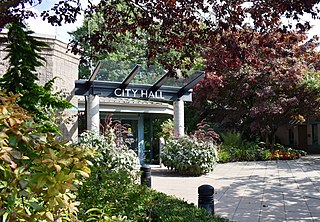
Park City is a city in Sedgwick County, Kansas, United States and a suburb of Wichita. As of the 2020 census, the population of the city was 8,333.

Macomb Township is a civil township of Macomb County in the U.S. state of Michigan. The population was 91,663 at the 2020 census, up from 79,580 in 2010. As of 2020 it was the most-populous civil township in the state and the third most-populous township overall after the charter townships of Clinton and Canton.

Ray Township is a civil township of Macomb County in the U.S. state of Michigan. As of the 2020 census, the township population was 3,780.

Balch Springs is a city in Dallas County, Texas, United States. It is an inner-ring suburb of Dallas and part of the Dallas–Fort Worth metroplex. Its population was 23,728 at the 2010 census, and 25,007 at 2019's census estimates.

Osceola is a village in Polk County, Wisconsin, United States. The population was 2,765 at the 2020 census. Located mostly within the Town of Osceola, the village sits on the border with Minnesota, separated by the St. Croix River. It is along Wisconsin Highway 35.
Pitt Meadows is a municipality of Metro Vancouver in southwestern British Columbia, Canada. Incorporated in 1914, it has a land area of 86.34 square kilometres (33.34 sq mi) and a population of 19,146 as of 2021. The municipality received its name from the Pitt River and Pitt Lake. Pitt Meadows is one of 21 municipalities plus Electoral Area A that comprises the Metro Vancouver Regional District.

South Holland is a local government district of Lincolnshire, England. The council is based in Spalding. Other notable towns and villages include Crowland, Sutton Bridge, Donington, Holbeach and Long Sutton. The district is named after the historical division of Lincolnshire known as the Parts of Holland.

The Japanese Friendship Garden is a walled section of Kelley Park in San Jose, California, United States. Dedicated in October 1965, it is patterned after Japan's famous Korakuen Garden in Okayama and spans six acres. Its three main ponds were stocked with koi sent from Okayama in 1966. The ponds are at different elevations in the park, and are inter-connected by streams.

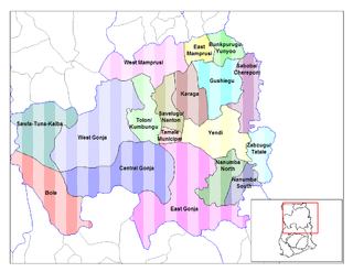
The Northern Region is one of the sixteen regions of Ghana. It is located in the north of the country and it is the second largest of the sixteen regions. Until it split, it covered an area of 70,384 square kilometres or 31 percent of Ghana's area. In December 2018, the Savannah Region and North East Region were created from it. The Northern Region is divided into 14 districts. The region's capital is Tamale, Ghana's third largest city.

West Gonja Municipal Assembly is one of the seven districts in Savannah Region, Ghana. Originally created as an ordinary district assembly on 23 December 1988 when it was known as West Gonja District, until the southern part of the district was split off by a decree of president John Agyekum Kufuor in August 2004 to create Central Gonja District; thus the remaining part was retained as West Gonja District. However, on 6 February 2012, the northern part of the district was later split off to create North Gonja District; thus the remaining part has been retained as West Gonja District. Later, it was elevated to municipal district assembly status on 27 January 2020 to become West Gonja Municipal District. The municipality is located in the central part of Savannah Region and has Damongo as its capital town.

Gushegu Municipal District is one of the sixteen districts in Northern Region, Ghana. Originally it was formerly part of the then-larger Gushegu-Karaga District in 1988, which was created from the former East Dagomba District Council, until the western part of the district was split off to create Karaga District on 27 August 2004; thus the remaining part has been renamed as Gushegu District, which it was later elevated to municipal district assembly status on that same year to become Gushegu Municipal District. The municipality is located in the northeast part of Northern Region and has Gushegu as its capital town.

Ellembelle District is one of the fourteen districts in Western Region, Ghana. Originally it was part of the then-larger Nzema East District in 1988, which was created from the former Nzema District Council, until the western part of the district was split off by a decree of then-president John Agyekum Kufuor on 29 February 2008 to create Ellembelle District; thus the remaining part has been retained as Nzema East District. The district assembly is located in the southwest part of Western Region and has Nkroful as its capital town.

Chereponi District is one of the six districts in North East Region, Ghana. Originally it was formerly part of the then-larger Saboba-Chereponi District in 1988, which was created from the former East Dagomba District Council, until the northern portion of the district was split off to become Chereponi District on 29 February 2008; thus the remaining part has been renamed as Saboba District. The district assembly is located in the southeast part of North East Region and has Chereponi as its capital town.
Saboba District is one of the sixteen districts in Northern Region, Ghana Originally it was formerly part of the then-larger Saboba-Chereponi District in 1988, which was created from the former East Dagomba District Council, until the northern part of the district was split off to create Chereponi District on 29 February 2008 ; thus the remaining part has been renamed as Saboba District. The district assembly is located in the northeast part of Northern Region and has Saboba as its capital town.

The Great Flood of 1913 severely affected Columbus, Ohio. The area most affected was Franklinton, also known as the Bottoms, for its low elevation near the Scioto River. Among many infrastructure projects, a 7.2-mile floodwall was built from 1993 to 2004 to protect most of Franklinton from flooding.
Saboba-Chereponi District is a former district that was located in Northern Region, Ghana. Originally created as an ordinary district assembly in 1988, which was created from the former East Dagomba District Council. However on 29 February 2008, it was split off into two new districts: Saboba District and Chereponi District. The district assembly was located in the northeast part of Eastern Region and had Saboba as its capital town.
East Dagomba District is a former district council that was located in Northern Region, Ghana. Originally created as an ordinary district assembly in 1975. However, on 1988, it was split off into four new district assemblies: Yendi Municipal District, Gushegu-Karaga District, Saboba-Chereponi District and Zabzugu-Tatale District. The district assembly was located in the eastern part of Northern Region and had Yendi as its capital town.

