Yendi Municipal District

Last updated
Yendi Municipal District
Naa Ya which means, The King's City
Municipal District
Nickname: 
Sankara Yili
Northern Ghana districts.png
Districts of Northern Region
Ghana adm location map.svg
Red pog.svg
Yendi Municipal District
Location of Yendi Municipal District within Northern
Coordinates: 9°26′26.88″N0°0′21.24″W / 9.4408000°N 0.0059000°W / 9.4408000; -0.0059000
CountryFlag of Ghana.svg  Ghana
Region Northern
Capital Yendi
Government
  Municipal Chief ExecutiveIssah Zakaria
Population
 (2021 census)
  Total154,421 [1]
Time zone UTC+0 (GMT)
ISO 3166 code GH-NP-YE

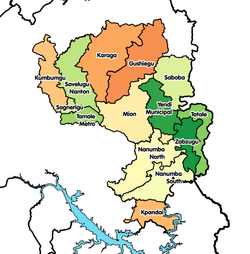
Yendi Municipal District is one of the sixteen districts in Northern Region, Ghana. Originally created as an ordinary district assembly in 1988 when it was known as Yendi District , which was created from the former East Dagomba District Council, until it was elevated to municipal district assembly status on 29 February 2008 to become Yendi Municipal District. However, on 28 June 2012, the western part of the district was later split to create Mion District with the remaining part retained as Yendi Municipal District. The municipality is located in the central part of Northern Region and has Yendi as its capital town.

Contents

History

Yendi is also the capital of the ancient Dagbon Kingdom. Yendi in the 17th century was the centre of commerce for the whole of the Gold Coast until colonial rule.

Bowdich, T. E. on his Mission from Cape Coast to Ashanti 1819 notes:

"177 7 days from Sallagah NE according to the Moors through the Inta town of Zongoo is Yahndi (Yendi) the capital of Dagombas.
178 Yahndi is described to be beyond comparison larger than Kumasi, the houses much better built and ornamented. Ashantis lost themselves in the streets. The King Nana Taquanee, has been converted by the Moors, who have settled there in great numbers. The markets at Yahndi are described as animated scenes of commerce, constantly crowded with merchants from almost all countries of the interior. Horses and cattle abound. Yahndi is named after the numeral one, from its pre-eminence.
179 One day from Sallagha, towards Yahndi, and scarcely one journey westward from the latter is the river Laka, described to be as large and as rapid as the Volta which it joins below Odentee.
188 The bush or country people of Dagwumba have three light cuts on each cheek bone and three below, with one horizontal under the eye; those of Yahndi three deep continued cuts These cuts are made during infancy, to insinuate fetish liquids to invigorate and preserve the child." [2]

Sources

Related Research Articles

Yaa Naa Yakubu Andani II (1945–2002) was the King of Dagbon, the traditional kingdom of the Dagomba people in northern Ghana, from 31 May 1974 until his assassination on 27 March 2002. He was born in August 1945 in Sagnarigu, a suburb of Tamale in the Northern Region of Ghana. Yakubu II was killed on 27 March 2002 at Yendi, the capital of the Kingdom of Dagbon, by unknown people when clashes broke out between the two feuding Gates of Dagbon Kingship. For 600 years the Abudu and Andani clans, named after two sons of the ancient Dagbon king Ya Naa Yakubu I, cordially rotated control of the kingdom centred in Yendi, 530 kilometres (330 mi) north of Accra, the capital of Ghana. A regent acted as sovereign of the kingdom until 18 January 2019 when a new ruler is chosen to occupy the revered Lion Skins of Yendi.

<span class="mw-page-title-main">Dagomba people</span> Ethnic group in Ghana

The Dagbamba or Dagomba are an ethnic group of Ghana, and Togo. They number more than 3.1 million people. The term Dagbamba is originally extended to refer to other related peoples who were unified by Naa Gbewaa including the Mamprusi and Nanumba. The Dagomba country is called Dagbon and they speak Dagbanli language. Dagbanli is the most spoken language of northern Ghana and second most widely spoken local language of Ghana. Dagbanli belongs to the Mabia (Mole-Dagbani) subgroup of the Gur languages, a large group of related languages in West Africa. The Dagomba practises both patrilineal and matrilineal systems of inheritance.

<span class="mw-page-title-main">Yendi</span> Town & District Capital in Northern Region, Ghana

Yendi , is the traditional capital of the Kingdom of Dagbon and the administrative centre of the Yendi Municipal District in the Northern Region of Ghana. As of 2021, the population of Yendi was 154,421 comprising 76,142 males and 78,279 females. It is the seat of the King of the Dagbon, Ghana's oldest kingdom.

<span class="mw-page-title-main">Northern Region (Ghana)</span> Region of Ghana

The Northern Region is one of the sixteen regions of Ghana. It is situated in the northern part of the country and ranks as the second largest of the sixteen regions. Before its division, it covered an area of 25,000 square kilometres, representing 10 percent of Ghana's area. In December 2018, the Savannah Region and North East Region were created from it. The Northern Region is divided into 16 districts. The region's capital is Tamale, Ghana's third largest city.

<span class="mw-page-title-main">Salaga</span> Town in Savannah Region, Ghana

Salaga is a town and is the capital of East Gonja district, a district in the Savannah Region of north Ghana. Salaga had a 2012 settlement population of 25,472 people. Salaga was the largest slave market in the 18th and 19th centuries.

<span class="mw-page-title-main">Savelugu-Nanton Municipal District</span> Former Municipal District in Northern, Ghana

Savelugu-Nanton Municipal District is a former district that was located in Northern Region, Ghana. Originally created as an ordinary district assembly in 1988; which was created from the former West Dagomba District Council. It was later elevated to municipal district assembly status on 1 March 2012. However on 28 June 2012, it was split off into two new districts: Savelugu Municipal District and Nanton District. The municipality was located in the eastern part of Northern Region and had Nanton as its capital town.

<span class="mw-page-title-main">Mampong Municipal District</span> Municipal District in Ashanti, Ghana

Mampong Municipal Assembly is one of the forty-three districts in Ashanti Region, Ghana. Originally it was formerly part of the then-larger Sekyere West District in 1988, which was created from the former Sekyere District Council. However on 1 November 2007, the eastern part of the district was split off to create Sekyere Central District; while the remaining portion has since then been officially renamed as Mampong Municipal District, which it was elevated to municipal district assembly status on that same year. The municipality is located in the northern part of Ashanti Region and has Mampong as its capital town.

<span class="mw-page-title-main">Tamale Metropolitan District</span> Metropolitan District in Northern, Ghana

Tamale Metropolitan District is one of the sixteen districts in the Northern Region of Ghana. It was originally established in 1988 as Tamale Municipal District, a municipal district assembly that was created from the former West Dagomba District Council. In August 2004, it was elevated to metropolitan district assembly status. Later, on 24 June 2012, a small northern part of the district was split off to create Sagnarigu District ; the remaining part has been retained as Tamale Metropolitan District. The district is located in the northwest part of Northern Region and has Tamale as its capital city. The city is the central business hub of the region.

<span class="mw-page-title-main">West Mamprusi Municipal Assembly</span> District in North East region, Ghana

West Mamprusi Municipal Assembly is one of the six districts in North East Region, Ghana. Originally created as an ordinary district assembly in 1988 when it was known as West Mamprusi District, which was created from the former Mamprusi District Council, until the western part of the district was split off on 28 June 2012 to create Mamprugu-Moagduri District; thus the remaining part has been retained as West Mamprusi District. However, on 15 March 2018, it was elevated to municipal district assembly status to become West Mamprusi Municipal District. The municipality is located in the western part of North East Region and has Walewale as its capital town. Other settlements within the municipal assembly include Wulugu.

<span class="mw-page-title-main">Atwima Nwabiagya Municipal District</span> Municipal District in Ashanti, Ghana

Atwima Nwabiagya Municipal District is one of the forty-three districts in Ashanti Region, Ghana. Originally created as an ordinary district assembly in 1988 when it was known as Atwima District. Later, part of the district was split off by a decree of president John Agyekum Kufuor on 12 November 2003 to create Atwima Mponua District; thus the remaining part was renamed to become Atwima Nwabiagya District. However on 15 March 2018, the northern part of the district was later split off to create Atwima Nwabiagya North District; while the remaining part was elevated to municipal district assembly status on the same year to become Atwima Nwabiagya Municipal District. The municipality is located in the western part of Ashanti Region and has Nkawie as its capital town.

<span class="mw-page-title-main">Gushegu Municipal District</span> Municipal District in Northern Region, Ghana

Gushegu Municipal District is one of the sixteen districts in Northern Region, Ghana. Originally it was formerly part of the then-larger Gushegu-Karaga District in 1988, which was created from the former East Dagomba District Council, until the western part of the district was split off to create Karaga District on 27 August 2004; thus the remaining part has been renamed as Gushegu District, which it was later elevated to municipal district assembly status on that same year to become Gushegu Municipal District. The municipality is located in the northeast part of Northern Region and has Gushegu as its capital town.

<span class="mw-page-title-main">Karaga District</span> District in Northern Region, Ghana

Karaga District is one of the sixteen districts in Northern Region, Ghana. Originally it was formerly part of the then-larger Gushegu-Karaga District in 1988, which was created from the former East Dagomba District Council, until the western part of the district was split off to create Karaga District on 27 August 2004; thus the remaining part has been renamed as Gushegu District, which it was later elevated to municipal district assembly status on that same year to become Gushegu Municipal District. The district assembly is located in the northeast part of Northern Region and has Karaga as its capital town.

<span class="mw-page-title-main">Bawku Municipal District</span> Municipal district in Upper East region, Ghana

Bawku Municipal District is one of the fifteen districts in Upper East Region, Ghana. Originally created as an ordinary district assembly in 1988 when it was known as Bawku East District; which was established by Legislative Instrument (L.I.) 1439, until the southern part of the district was split off by a decree of president John Agyekum Kufuor in August 2004 to create Garu-Tempane District; thus the remaining part was elevated to municipal district assembly status on the same year to become Bawku Municipal District. However, on 28 June 2012, two parts of the district were later split off to create Binduri District and Pusiga District respectively; thus the remaining part has been retained as Bawku Municipal District. The municipality is located in the eastern part of Upper East Region and has Bawku as its capital town.

<span class="mw-page-title-main">Chereponi District</span> District in North East Region, Ghana

Chereponi District is one of the six districts in North East Region, Ghana. Originally it was formerly part of the then-larger Saboba-Chereponi District in 1988, which was created from the former East Dagomba District Council, until the northern portion of the district was split off to become Chereponi District on 29 February 2008; thus the remaining part has been renamed as Saboba District. The district assembly is located in the southeast part of North East Region and has Chereponi as its capital town.

Bimbilla is the capital town of Nanumba North District, a district in the Northern Region of Ghana. It is located in the East of the region, and is near the Oti River. The location is situated within the range of 8.5° north to 9.25° north latitude, and between 0.57° east to 0.5° east longitude. It borders five municipalities: Yendi Municipal to the north, Mion Municipal to the northwest, East Gonja Municipal to the west and southwest, Nanumba South Municipal to the south and east, and Zabzugu Municipal to the north-northeast.

<span class="mw-page-title-main">Mion District</span> District in Northern Region, Ghana

Mion District is one of the sixteen districts in Northern Region, Ghana. Originally it was formerly part of the then-larger Yendi District in 1988, which was created from the former East Dagomba District Council, until the western part of the district was later split off to create Mion District on 28 June 2012; thus the remaining original part has bee retained to become Yendi Municipal District. The district assembly is located in the central part of Northern Region and has Sang as its capital town.

<span class="mw-page-title-main">Kwabre East Municipal District</span> Municipal District in Ashanti, Ghana

Kwabre East Municipal District is one of the forty-three districts in Ashanti Region, Ghana. Originally created as an ordinary district assembly in 1988 when it was known as Kwabre District, after it was created from part of the former Kwabre-Sekyere District Council; until the western part of the district was split off to become the southern portion of Afigya-Kwabre District on 1 November 2007 ; while the remaining portion has since then been officially renamed as Kwabre East District, which it was elevated to municipal district assembly status to become Kwabre East Municipal District on 1 November 2017. The municipality is located in the northern part of Ashanti Region and had Mamponteng as its capital town.

<span class="mw-page-title-main">Saboba-Chereponi District</span> Former District in Northern, Ghana

Saboba-Chereponi District is a former district that was located in Northern Region, Ghana. Originally created as an ordinary district assembly in 1988, which was created from the former East Dagomba District Council. However on 29 February 2008, it was split off into two new districts: Saboba District and Chereponi District. The district assembly was located in the northeast part of Eastern Region and had Saboba as its capital town.

<span class="mw-page-title-main">West Dagomba District</span> Former District Council in Northern, Ghana

West Dagomba District is a former district council that was located in Northern Region, Ghana. Originally created as an ordinary district assembly in 1975. However on 1988, it was split off into three new district assemblies: Tamale Municipal District, Savelugu-Nanton District and Tolon-Kumbungu District. The district assembly was located in the western part of Northern Region and had Tamale as its capital town.

<span class="mw-page-title-main">East Dagomba District</span> Former District Council in Northern, Ghana

East Dagomba District is a former district council that was located in Northern Region, Ghana. Originally created as an ordinary district assembly in 1975. However, on 1988, it was split off into four new district assemblies: Yendi Municipal District, Gushegu-Karaga District, Saboba-Chereponi District and Zabzugu-Tatale District. The district assembly was located in the eastern part of Northern Region and had Yendi as its capital town.

References

9°26′26.88″N0°0′21.24″W / 9.4408000°N 0.0059000°W / 9.4408000; -0.0059000