
East Mamprusi Municipal Assembly is one of the six districts in North East Region, Ghana. Originally created as an ordinary district assembly in 1988 when it was known as East Mamprusi District, which was created from the former Mamprusi District Council, until the eastern part of the district was split off by a decree of president John Agyekum Kufuor on 19 August 2004 to create Bunkpurugu-Yunyoo District; thus the remaining part has been retained as East Mamprusi District. However on 15 March 2018, it was elevated to municipal district assembly status to become East Mamprusi Municipal District. The municipality is located in the eastern part of North East Region and has Gambaga as its capital town.
West Mamprusi Municipal Assembly is one of the six districts in North East Region, Ghana. Originally created as an ordinary district assembly in 1988 when it was known as West Mamprusi District, which was created from the former Mamprusi District Council, until the western part of the district was split off on 28 June 2012 to create Mamprugu-Moagduri District; thus the remaining part has been retained as West Mamprusi District. However, on 15 March 2018, it was elevated to municipal district assembly status to become West Mamprusi Municipal District. The municipality is located in the western part of North East Region and has Walewale as its capital town. Other settlements within the municipal assembly include Wulugu.

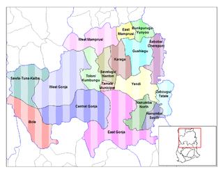
Karaga District is one of the sixteen districts in Northern Region, Ghana. Originally it was formerly part of the then-larger Gushegu-Karaga District in 1988, which was created from the former East Dagomba District Council, until the western part of the district was split off to create Karaga District on 27 August 2004; thus the remaining part has been renamed as Gushegu District, which it was later elevated to municipal district assembly status on that same year to become Gushegu Municipal District. The district assembly is located in the northeast part of Northern Region and has Karaga as its capital town.

Bawku Municipal District is one of the fifteen districts in Upper East Region, Ghana. Originally created as an ordinary district assembly in 1988 when it was known as Bawku East District; which was established by Legislative Instrument (L.I.) 1439, until the southern part of the district was split off by a decree of president John Agyekum Kufuor in August 2004 to create Garu-Tempane District; thus the remaining part was elevated to municipal district assembly status on the same year to become Bawku Municipal District. However, on 28 June 2012, two parts of the district were later split off to create Binduri District and Pusiga District respectively; thus the remaining part has been retained as Bawku Municipal District. The municipality is located in the eastern part of Upper East Region and has Bawku as its capital town.

Birim Central Municipal District is one of the thirty-three districts in Eastern Region, Ghana. Originally created as an ordinary district assembly in 1988 when it was known as the first Birim South District, which it was created from the former Birim District Council, until the western part of the district was split off to create a new Birim South District, with Akim Swedru as its capital town; thus the remaining part has been renamed as Birim Central Municipal District on 29 February 2008, with Akim Oda as its capital town, which it was elevated to municipal district assembly status on that same year. However on 15 March 2018, the southeast part of the district was split off to become Asene-Manso-Akroso District; thus the remaining part has been retained as Birim Central Municipal District. The municipality is located in the southwest part of Eastern Region and has Akim Oda as its capital town.
Naa Gbewaa is the founder of the Kingdom of Dagbon, in what is now northern Ghana. His sons and daughters are credited with founding several states, including the Mossi kingdoms of Burkina Faso. He established a stable and prosperous kingdom. Naa Gbewaa's shrine is located at Pusiga, 90 km east of Bolgatanga. His descendants continue to pay respects at the shrine.
Savelugu is one of the constituencies represented in the Parliament of Ghana. It elects one member of parliament (MP) by the first-past-the-post system of election. Savelugu is located in the Northern Region of Ghana. Hajia Mary Salifu Boforo serve the constituency as a member of parliament in the 2nd, 3rd, 4th, 5th and 6th parliament of the Fourth Republic of Ghana. She was elected on the ticket of the National Democratic Congress (NDC) and won a majority of 6,434 votes more than candidate closest in the race to win the constituency election, becoming the MP. She had earlier represented the constituency in the 4th Republican parliament.
Walewale is one of the constituencies represented in the Parliament of Ghana. It elects one Member of Parliament (MP) by the [first past the post] / Simple Majority] system of election. Walewale is located in the West Mamprusi Municipal of the North East Region of Ghana. It is the Municipal capital of West Mamprusi Municipal Assembly. The constituency was formerly called the West Mamprusi Constituency.
Nalerigu is the largest town in the East Mamprusi Municipal Assembly in the North East Region of Ghana as well as the traditional capital of the Mamprusi people, the seat of the Paramount chief, the NaYiri. Nalerigu is also the capital of the Northeast Region of Ghana. The Northeast Region, one of the six new regions established nationwide in 2018, has its administrative headquarters in Nalerigu.

Walewale is a town and the capital of Mamprusi West Municipal in the North East Region of Ghana. The West Mamprusi Municipal is one of the 261 Metropolitan, Municipal, and District Assemblies (MMDAs) in Ghana, and forms part of the 6 MMDAs in the North East Region. The West Mamprusi Municipality is one of 45 new districts created in 1988 under the Government of Ghana’s decentralization and was later replaced with LI 2061 in 2012. With its administrative capital as Walewale.
Bimbilla is the capital town of Nanumba North District, a district in the Northern Region of Ghana. It is located in the East of the region, and is near the Oti River. The location is situated within the range of 8.5° north to 9.25° north latitude, and between 0.57° east to 0.5° east longitude. It borders five municipalities: Yendi Municipal to the north, Mion Municipal to the northwest, East Gonja Municipal to the west and southwest, Nanumba South Municipal to the south and east, and Zabzugu Municipal to the north-northeast.
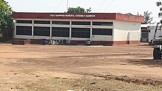
Gambaga is the capital of the East Mamprusi Municipal Assembly in the North East Region of Ghana. Once a residence of Mamprusi-kings it is still the capital of East Mamprusi Municipal Assembly, a municipality in the North East Region of Ghana. It is home to several ancient Mossi chiefs' gravesites.
Gushegu is the capital city of the Gushegu District, a district located in the Northern Region of Ghana. It is an important city in the Kingdom of Dagbon. It is located in the eastern part of Dagbong with Naa Yab' Gushe-Naa as its traditional head.
Garu is a town and is the administrative capital of Garu District, a district in the Upper East Region of northern Ghana.
Mion District is one of the sixteen districts in Northern Region, Ghana. Originally it was formerly part of the then-larger Yendi District in 1988, which was created from the former East Dagomba District Council, until the western part of the district was later split off to create Mion District on 28 June 2012; thus the remaining original part has bee retained to become Yendi Municipal District. The district assembly is located in the central part of Northern Region and has Sang as its capital town.
Mamprugu-Moagduri District is one of the six districts in North East Region, Ghana. Originally it was formerly part of a then-larger West Mamprusi District in 1988, which was created from the former Mamprusi District Council, until the western part of the district was split off on 28 June 2012 to create Mamprugu-Moagduri District; thus the remaining part was still has been retained West Mamprusi District. The district assembly is located in the western part of North East Region and has Yagaba as its capital town.
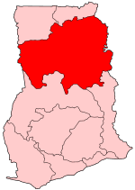
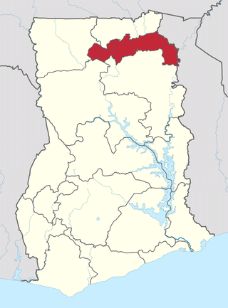
The North East Region is one of the sixteen regions of Ghana. It is located in the north of the country and was created in December 2018 after a referendum was voted upon to break it off of the Northern region. The region's capital is Nalerigu.
Bunkpurugu-Yunyoo District is a former district that was located in Northern Region, Ghana. Originally it was formerly part of the then-larger East Mamprusi District in 1988, which was created from the former Mamprusi District Council. However on 15 March 2018, it was split out into two new districts: Bunkpurugu-Nyankpanduri District and Yunyoo-Nasuan District. The district assembly was located in the north east part of Northern Region and had Bunkpurugu as its capital town. It is currently part of the North East region of Ghana.
Gushegu-Karaga District is a former district that was located in Northern Region, Ghana. Originally created as an ordinary district assembly in 1988, which was created from the former East Dagomba District Council. However on 28 June 2012, it was split off into two new districts: Gushegu District and Karaga District. The district assembly was located in the northeast part of Northern Region and had Gushegu as its capital town.
East Dagomba District is a former district council that was located in Northern Region, Ghana. Originally created as an ordinary district assembly in 1975. However, on 1988, it was split off into four new district assemblies: Yendi Municipal District, Gushegu-Karaga District, Saboba-Chereponi District and Zabzugu-Tatale District. The district assembly was located in the eastern part of Northern Region and had Yendi as its capital town.

