The Upper East Region is located in north Ghana and is the third smallest of the 16 administrative regions in Ghana. It occupies a total land surface of 8,842 square kilometers or 2.7 per cent of the total land area of Ghana. The Upper East regional capital is Bolgatanga, sometimes referred to as Bolga. Other major towns in the region include Navrongo, Paga, Bawku and Zebilla.

The Greater Accra Region has the smallest area of Ghana's 16 administrative regions, occupying a total land surface of 3,245 square kilometres. This is 1.4 per cent of the total land area of Ghana. It is the second most populated region, before the Ashanti Region, with a population of 5,455,692 in 2021, accounting for 17.7 per cent of Ghana's total population.

The Northern Region is one of the sixteen regions of Ghana. It is located in the north of the country and was the largest of the sixteen regions, covering an area of 70,384 square kilometres or 31 percent of Ghana's area until December 2018 when the Savannah Region and North East Region were created from it. The Northern Region is divided into 14 districts. The region's capital is Tamale.

Atebubu-Amantin Municipal District is one of the eleven districts in Bono East Region, Ghana. Originally it was formerly part of the then-larger Atebubu District on 10 March 1989, until the northern part of the district was split off to create Pru District on 12 November 2003 ; thus the remaining part has been renamed as Atebubu-Amantin District, which it was later elevated to municipal district assembly status on 15 March 2018 to become Atebubu-Amantin Municipal District. The municipality is located in the east central part of Bono East Region and has Atebubu as its capital town.

East Mamprusi Municipal Assembly is one of the six districts in North East Region, Ghana. Originally created as an ordinary district assembly in 1988 when it was known as East Mamprusi District, which was created from the former Mamprusi District Council, until the eastern part of the district was split off by a decree of president John Agyekum Kufuor on 19 August 2004 to create Bunkpurugu-Yunyoo District; thus the remaining part has been retained as East Mamprusi District. However on 15 March 2018, it was elevated to municipal district assembly status to become East Mamprusi Municipal District. The municipality is located in the eastern part of North East Region and has Gambaga as its capital town.
West Mamprusi Municipal Assembly is one of the six districts in North East Region, Ghana. Originally created as an ordinary district assembly in 1988 when it was known as West Mamprusi District, which was created from the former Mamprusi District Council, until the western part of the district was split off on 28 June 2012 to create Mamprugu-Moagduri District; thus the remaining part has been retained as West Mamprusi District. However, on 15 March 2018, it was elevated to municipal district assembly status to become West Mamprusi Municipal District. The municipality is located in the western part of North East Region and has Walewale as its capital town. Other settlements within the municipal assembly include Wulugu.

Pru District is a former district that was located in Brong-Ahafo Region, Ghana. Originally it was formerly part of the then-larger Atebubu District on 10 March 1989, until the northern part was split off to create Pru District; thus the remaining part has been renamed as Atebubu-Amantin District, which it was elevated to municipal district assembly status on 15 March 2018 to become Atebubu-Amantin Municipal District. However on 15 March 2018, it was split off into two new districts: Pru East District and Pru West District. The district assembly was located in the east central part of Brong-Ahafo Region and had Yeji as its capital town.

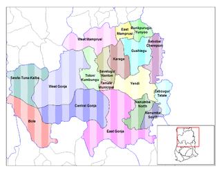
Gushegu Municipal District is one of the sixteen districts in Northern Region, Ghana. Originally it was formerly part of the then-larger Gushegu-Karaga District in 1988, which was created from the former East Dagomba District Council, until the western part of the district was split off to create Karaga District on 27 August 2004; thus the remaining part has been renamed as Gushegu District, which it was later elevated to municipal district assembly status on that same year to become Gushegu Municipal District. The municipality is located in the northeast part of Northern Region and has Gushegu as its capital town.
Chereponi District is one of the six districts in North East Region, Ghana. Originally it was formerly part of the then-larger Saboba-Chereponi District in 1988, which was created from the former East Dagomba District Council, until the northern portion of the district was split off to become Chereponi District on 29 February 2008; thus the remaining part has been renamed as Saboba District. The district assembly is located in the southeast part of North East Region and has Chereponi as its capital town.
Kpandai District is one of the sixteen districts in Northern Region, Ghana. Originally it was formerly part of the then-larger East Gonja District in 1988, until the eastern part of the district was split off by a decree of president John Agyekum Kufuor on 29 February 2008 to create Kpandai District.; thus the remaining part has been retained as East Gonja Municipal District. The district assembly is located in the southern part of Northern Region and has Kpandai as its capital town.
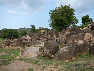
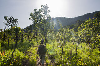
Saboba is a small town and is the capital of Saboba district, a district in the Northern Region of north Ghana. The primary economic activity is farming. Tribes like kokombas, kotokoli, chakosi and dagombas can be found in this district. Currently, Charles Bintin is the member of Parliament for Saboba and its neighbouring villages.
Mion District is one of the sixteen districts in Northern Region, Ghana. Originally it was formerly part of the then-larger Yendi District in 1988, which was created from the former East Dagomba District Council, until the western part of the district was later split off to create Mion District on 28 June 2012; thus the remaining original part has bee retained to become Yendi Municipal District. The district assembly is located in the central part of Northern Region and has Sang as its capital town.
Mamprugu-Moagduri District is one of the six districts in North East Region, Ghana. Originally it was formerly part of a then-larger West Mamprusi District in 1988, which was created from the former Mamprusi District Council, until the western part of the district was split off on 28 June 2012 to create Mamprugu-Moagduri District; thus the remaining part was still has been retained West Mamprusi District. The district assembly is located in the western part of North East Region and has Yagaba as its capital town.
The Oti Region is one of the six newly created regions of Ghana in December 2018. The region was carved out of the northern part of the Volta Region and will be in fulfillment of a campaign promise made by New Patriotic Party. Prior to the 2016 Ghanaian general election, the then candidate Nana Akufo-Addo declared that when elected, he would explore the possibility of creating new regions out of some of the existing regions in Ghana in order to bring government closer to citizens.
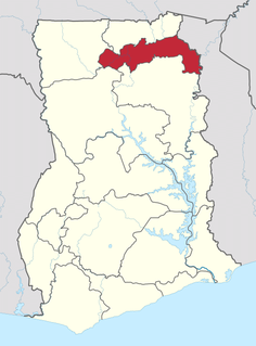
The North East Region is one of the sixteen regions of Ghana. It is located in the north of the country and was created in December 2018 after a referendum was voted upon to break it off of the Northern region. The region's capital is Nalerigu.
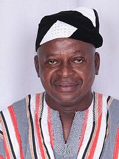
Charles Binipom Bintin is a Ghanaian politician and member of the Seventh Parliament of the Fourth Republic of Ghana representing the Saboba Constituency in the Northern Region on the ticket of the New Patriotic Party.
Joseph Nikpe Bukari is a Ghanaian politician and member of the Sixth Parliament of the Fourth Republic of Ghana representing the Saboba Constituency in the Northern Region of Ghana.

The Bono East region of Ghana is a new region carved out of the Brong Ahafo region. The capital of the new region is Techiman. This creation of this new region was in fulfillment of a promise made by the New Patriotic Party prior to the 2016 Ghana general election. Upon winning the elections, the President, Nana Akuffo Addo created the Ministry of Regional Reorganization to oversee policy formulation and implementation. In all six new regions are to be created from the existing ten regions of Ghana. The other regions are Bono, Western North, Ahafo, Savannah, North East, and Oti regions.
Saboba-Chereponi District is a former district that was located in Northern Region, Ghana. Originally created as an ordinary district assembly in 1988, which was created from the former East Dagomba District Council. However on 29 February 2008, it was split off into two new districts: Saboba District and Chereponi District. The district assembly was located in the northeast part of Eastern Region and had Saboba as its capital town.
East Dagomba District is a former district council that was located in Northern Region, Ghana. Originally created as an ordinary district assembly in 1975. However on 1988, it was split off into four new district assemblies: Yendi Municipal District, Gushegu-Karaga District, Saboba-Chereponi District and Zabzugu-Tatale District. The district assembly was located in the eastern part of Northern Region and had Yendi as its capital town.

