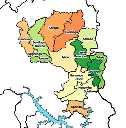
Kpandai District

Last updated
Kpandai District
Nawuri
Districts of the Northern Region (2018).png
Districts of Northern Region
Ghana adm location map.svg
Red pog.svg
Kpandai District
Location of Kpandai District within Northern Region, Ghana
Coordinates: 8°28′12″N0°1′12″W / 8.47000°N 0.02000°W / 8.47000; -0.02000
CountryFlag of Ghana.svg  Ghana
Region Northern
Capital Kpandai
Government
  District ExecutiveHon. Atta Kofi Tatablata
Area
  Total1,772 km2 (684 sq mi)
Population
 (2021)
  Total126,213
Time zone UTC+0 (GMT)
ISO 3166 code GH-NP-KP

Kpandai District [1] is one of the sixteen districts in Northern Region, Ghana. [2] Originally it was formerly part of the then-larger East Gonja District in 1988, until the eastern part of the district was split off by a decree of president John Agyekum Kufuor on 29 February 2008 to create Kpandai District.; thus the remaining part has been retained as East Gonja Municipal District . The district assembly is located in the southern part of Northern Region [3] and has Kpandai as its capital town.

Contents

Geography

The district shares boundaries with East Gonja to the west, Nanumba South to the north, Nkwanta North and Nkwanta South to the East and Krachi West to the south.

Population

The district is largely rural, with approximately 90% of the population engaged in local agriculture. [4] As of the 2010 census, the district population was 108,816 and included at least 24 different ethnic groups. [4] The district has a total population of 108,816, which is made up of 54,997 (50.54 percent) males and 53,819 (49.46 percent) females. The district has an urban population of 10,824 representing 9.9 percent and rural population 97,992 representing 90.1 percent.

Sources

Related Research Articles

<span class="mw-page-title-main">Demographics of Ghana</span>

Demographic features of the population of Ghana include population density, ethnicity, education level, health of the populace, religious affiliations, and other aspects.

<span class="mw-page-title-main">Districts of Ghana</span> Second-level administrative subdivisions of Ghana

The Districts of Ghana are second-level administrative subdivisions of Ghana, below the level of region. There are currently 261 local metropolitan, municipal and district assemblies.

<span class="mw-page-title-main">Upper East Region</span> Region of Ghana

The Upper East Region is located in north Ghana and is the third smallest of the 16 administrative regions in Ghana. It occupies a total land surface of 8,842 square kilometers or 2.7 per cent of the total land area of Ghana. The Upper East regional capital is Bolgatanga, sometimes referred to as Bolga. Other major towns in the region include Navrongo, Paga, Bawku and Zebilla.

<span class="mw-page-title-main">East Gonja Municipal District</span> Municipal District in Savannah region, Ghana

East Gonja Municipal Assembly is one of the seven districts in Savannah Region, Ghana. Originally created as an ordinary district assembly in 1988 when it was known as East Gonja District, until the eastern part of the district was split off by a decree of president John Agyekum Kufuor on 29 February 2008 to create Kpandai District ; thus the remaining part has been retained as East Gonja District. Later, it was elevated to municipal district assembly status on 15 March 2018 to become East Gonja Municipal District. However on 19 February 2019, the northern part of the district was later split off to create North East Gonja District; thus remaining part has been retained as East Gonja Municipal District. The municipality is located in the eastern part of Savannah Region and has Salaga as its capital town.

<span class="mw-page-title-main">West Gonja Municipal District</span> Municipal District in Savannah, Ghana

West Gonja Municipal Assembly is one of the seven districts in Savannah Region, Ghana. Originally created as an ordinary district assembly on 23 December 1988 when it was known as West Gonja District, until the southern part of the district was split off by a decree of president John Agyekum Kufuor in August 2004 to create Central Gonja District; thus the remaining part was retained as West Gonja District. However, on 6 February 2012, the northern part of the district was later split off to create North Gonja District; thus the remaining part has been retained as West Gonja District. Later, it was elevated to municipal district assembly status on 27 January 2020 to become West Gonja Municipal District. The municipality is located in the central part of Savannah Region and has Damongo as its capital town.

<span class="mw-page-title-main">West Mamprusi Municipal Assembly</span> District in North East region, Ghana

West Mamprusi Municipal Assembly is one of the six districts in North East Region, Ghana. Originally created as an ordinary district assembly in 1988 when it was known as West Mamprusi District, which was created from the former Mamprusi District Council, until the western part of the district was split off on 28 June 2012 to create Mamprugu-Moagduri District; thus the remaining part has been retained as West Mamprusi District. However, on 15 March 2018, it was elevated to municipal district assembly status to become West Mamprusi Municipal District. The municipality is located in the western part of North East Region and has Walewale as its capital town. Other settlements within the municipal assembly include Wulugu.

<span class="mw-page-title-main">Krachi East Municipal District</span> Municipal District in Ghana

Krachi East Municipal District is one of the eight districts in Oti Region, Ghana. Originally it was formerly part of the then-larger Krachi District on 1988, until the eastern part of the district was split off to create Krachi East District on 19 August 2004, which was established by Legislative Instrument (L.I.) 1755; thus the remaining part has been renamed to become Krachi West District. However, on 14 November 2017, it was later elevated to municipal district assembly status to become Krachi East Municipal District; which was established by Legislative Instrument (L.I.) 2281. The municipality is located in the northern part of Oti Region and has Dambai as its capital town.

<span class="mw-page-title-main">Bawku Municipal District</span> Municipal district in Upper East region, Ghana

Bawku Municipal District is one of the fifteen districts in Upper East Region, Ghana. Originally created as an ordinary district assembly in 1988 when it was known as Bawku East District; which was established by Legislative Instrument (L.I.) 1439, until the southern part of the district was split off by a decree of president John Agyekum Kufuor in August 2004 to create Garu-Tempane District; thus the remaining part was elevated to municipal district assembly status on the same year to become Bawku Municipal District. However, on 28 June 2012, two parts of the district were later split off to create Binduri District and Pusiga District respectively; thus the remaining part has been retained as Bawku Municipal District. The municipality is located in the eastern part of Upper East Region and has Bawku as its capital town.

<span class="mw-page-title-main">Krachi West (Ghana parliament constituency)</span>

Krachi West is one of the constituencies represented in the Parliament of Ghana. It elects one Member of Parliament (MP) by the first past the post system of election. Krachi West is located in the Krachi district of the Oti Region of Ghana.

<span class="mw-page-title-main">Builsa North (Ghana parliament constituency)</span> Constituency in Ghana

Builsa North is one of the constituencies represented in the Parliament of Ghana. It elects one Member of Parliament (MP) by the first past the post system of election. Builsa North is located in the Builsa district of the Upper East Region of Ghana.

Kpassa is the capital of Nkwanta North District, a district in the Oti Region of Ghana. The Oti Region was part of the Volta Region of Ghana until 2019. The inhabitants of Kpassa are mostly Konkomba people. The other inhabitants are Basare. The Bassares and famous for their fire dance.There are also Akan, Ewe, Anufo, Krachi and Gonja people. In the past, the inhabitants of Kpassa have mainly engaged in farming. This trend has changed during the past two decades. Younger inhabitants are actively pursuing education and small-scale business activities, while the older ones are into governance. As a result, Kpassa has undergone rapid expansion during these past two decades. The town is expected to expand further once the Eastern Corridor Road Project is completed. In terms of architecture, a returning visitor will easily noticed that the town is rapidly shifting from mud buildings or atakpame to modern block buildings. In fact, most people in the town attach this shift to prestige and affluence in the society. At the current rate, one is expected to find fewer atakpame buildings a decade in the future. The economy of Kpassa is critical to the Volta Region, owing to its engagement in the production of valuable agricultural products such as corn, yam, cassava, millet, groundnuts, pepper, soya beans, and beans, among others.

Nawuri is a Guang language of Ghana. It is nearly intelligible with Kyode.

<span class="mw-page-title-main">Walewale</span> District Capital in North East Region, Ghana

Walewale is a town and the capital of Mamprusi West Municipal in the North East Region of Ghana. The West Mamprusi Municipal is one of the 261 Metropolitan, Municipal and District Assemblies (MMDAs) in Ghana, and forms part of the 6 MMDAs in the North East Region. The West Mamprusi Municipal is one of 45 new districts created in 1988 under the Government of Ghana’s decentralization and was later replaced with LI 2061 in 2012. With its administrative capital as Walewale.

Kpandai is a town and is the capital of Kpandai district, a district in the Northern Region of north Ghana. Kpandai had a 2012 settlement population of 11,239 people.

Bimbilla is the capital town of Nanumba North District, a district in the Northern Region of Ghana. It is located in the East of the region, and is near the Oti River.

<span class="mw-page-title-main">Mion District</span> District in Northern region, Ghana

Mion District is one of the sixteen districts in Northern Region, Ghana. Originally it was formerly part of the then-larger Yendi District in 1988, which was created from the former East Dagomba District Council, until the western part of the district was later split off to create Mion District on 28 June 2012; thus the remaining original part has bee retained to become Yendi Municipal District. The district assembly is located in the central part of Northern Region and has Sang as its capital town.

<span class="mw-page-title-main">Afadzato South District</span> District in Ghana

Afadzato South District is one of the eighteen districts in Volta Region, Ghana. Originally it was formerly part of the then-larger Hohoe District on 10 March 1989, until the southern part of the district was split off to create Afadzato South District on 28 June 2012; thus the remaining portion has been retained as Hohoe Municipal District. The district assembly is located in the northern part of Volta Region and has Ve Golokwati as its capital town.

<span class="mw-page-title-main">North Gonja (district)</span> District in Savannah, Ghana

North Gonja District is one of the seven districts in Savannah Region, Ghana. Originally it was formerly part of the then-larger West Gonja District on 23 December 1988, until the northern part of the district was split off on 28 June 2012 to create North Gonja District; thus the remaining part has been retained as West Gonja Municipal District. The district assembly is located in the central part of Savannah Region and has Daboya as its capital town. In 2023, the District Chief Executive is Adam Illiasu.

<span class="mw-page-title-main">Savannah Region</span> Region of Ghana

The Savannah Region is one of the newest regions of Ghana and yet the largest region in the country. The creation of the Region follows presentation of a petition by the Gonja Traditional Council, led by the Yagbonwura Tumtumba Boresa Jakpa I. Upon receiving favourable responses from all stakeholders in the Northern Region, the Brobbey Commission, a referendum was conducted on the 27th December 2018. The result was a resounding yes of 99.7%. The President of the Republic of Ghana signed and presented the Constitutional Instrument (CI) 115 to the Yagbonwura in the Jubilee House, Accra on 12 February 2019. The launch was well attended by sons and daughters of Gonjaland including all current and past Mps, MDCEs and all appointees with Gonjaland descent. Damongo was declared the capital of the new Savannah Region. It is located in the north of the country. The Savannah Region is divided into 7 districts; Bole, Central Gonja, North Gonja, East Gonja, Sawla/Tuna/Kalba, West Gonja, North East Gonja and 7 Constituencies; Bole/Bamboi, Damongo, Daboya/Mankarigu, Salaga North, Salaga South, Sawla/Tuna/Kalba and Yapei/Kusawgu. The capital of Bole district is Bole; East Gonja municipal is Salaga; West Gonja district is Damango; Sawla Tuna Kalba district is Salwa; Central Gonja is Buipe; North Gonja is Daboya; and North East Gonja is Kpalbe

Banda Nkwanta Mosque is located in the West Gonja District in the formally Northern region of Ghana. It is now in the Savannah region. Banda Nkwanta is a small town along the intersection of the Bui Dam road and the Wa-Techiman highway.

References

  1. "One District One Factory (1D1F)". www.moti.gov.gh. Archived from the original on 2021-04-11. Retrieved 2021-04-11.
  2. "Northern » Kpandai". Archived from the original on 2013-03-05. Retrieved 2013-06-18.
  3. "Ghana Northern Region". www.modernghana.com. Retrieved 2021-04-11.
  4. 1 2 Ghana Statistical Service (2014). "2010 Population & Housing Census: Kpandai District Analytical Report" (PDF). Archived from the original (PDF) on 2016-03-05. Retrieved 2018-10-13.

8°28′12″N0°1′12″W / 8.47000°N 0.02000°W / 8.47000; -0.02000