Kpandai

Last updated

Kpandai
Kpandae
Town & District Capital
Ghana adm location map.svg
Red pog.svg
Kpandai
Location of Kpandai in Northern region
Coordinates: 8°28′12″N0°1′12″W / 8.47000°N 0.02000°W / 8.47000; -0.02000
CountryGhana
Region Northern Region
District Kpandai District
Population
 (2012)
  Total11,239 [1]
Time zone GMT
  Summer (DST) GMT

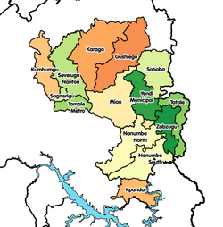
Kpandai is a town and is the capital of Kpandai district, a district in the Northern Region of north Ghana. [2] Kpandai had a 2012 settlement population of 11,239 people. [1]

Population

Kpandai is counter claimed by the Gonjas and Nawuris both of the Guan ethnic extraction. The contention led to several skirmishes in the early 1990s which the Nawuri's defeated the Gonja's.

Kpandai is inhabited by different groups including, the Nawuris, the Komkombas, the Bassares and the Kotokolis. There are also other smaller groups including Akan trading settlers. Kpandai is both in the Northern Volta and the Southern tip of the Northern region. The inhabitants are predominantly farmers who engage in farming yam and grains such as corn. Most of the yams are shipped to the capital Accra and further on abroad. The town has produced many university graduates over the years many of who have gone on to do well. Most of these would have had their Secondary education in Salaga, and the many secondary schools in Tamale. Kpandai is known for its many mangoe trees and a little plantation of Coconut.

The Catholic Church, the Seventh Day Adventist Church of Ghana and the Church of Pentecost are the biggest religious organisations. There is however also a sizeable Muslim population and Islam is growing. Many of the inhabitants combine traditional religious beliefs and Western/Arabian religions.

Related Research Articles

<span class="mw-page-title-main">Wa, Ghana</span> Town in Upper West Region, Ghana

Wa is a town and the capital of Wa Municipal District and the Upper West Region of northern Ghana. Wa had a 2012 settlement population of 102,446. Features of the town include several churches and mosques, the Wa-Na Palace, the St. Andrew's Catholic cathedral, the University for Development Studies (UDS), a museum, a nearby hippopotamus sanctuary in Wicheau, the mushroom rock In Jirapa and the ants hill at Nanvielle. The geography of Wa is notable for the dramatic monadnock Ombo Mountain, which is located around Kaleo and visible from much of the Wa town. Other notable towns around Wa region include Naaha and Ga.

<span class="mw-page-title-main">Yendi</span> Town & District Capital in Northern Region, Ghana

Yendi is a town and the capital of Yendi Municipal district in the Northern Region of Ghana. As of 2012 the population of Yendi was 52,008 people. It is the seat of the King of the Dagombas.

<span class="mw-page-title-main">Salaga</span> Town in Savannah Region, Ghana

Salaga is a town and is the capital of East Gonja district, a district in the Savannah Region of north Ghana. Salaga had a 2012 settlement population of 25,472 people. Salaga became the largest slave market where people were bought, sold, or traded for cattle, nevertheless, between the 18th and 19th centuries.

<span class="mw-page-title-main">East Gonja Municipal District</span> Municipal District in Savannah region, Ghana

East Gonja Municipal Assembly is one of the seven districts in Savannah Region, Ghana. Originally created as an ordinary district assembly in 1988 when it was known as East Gonja District, until the eastern part of the district was split off by a decree of president John Agyekum Kufuor on 29 February 2008 to create Kpandai District ; thus the remaining part has been retained as East Gonja District. Later, it was elevated to municipal district assembly status on 15 March 2018 to become East Gonja Municipal District. However on 19 February 2019, the northern part of the district was later split off to create North East Gonja District; thus remaining part has been retained as East Gonja Municipal District. The municipality is located in the eastern part of Savannah Region and has Salaga as its capital town.

<span class="mw-page-title-main">West Gonja Municipal District</span> Municipal District in Savannah, Ghana

West Gonja Municipal Assembly is one of the seven districts in Savannah Region, Ghana. Originally created as an ordinary district assembly on 23 December 1988 when it was known as West Gonja District, until the southern part of the district was split off by a decree of president John Agyekum Kufuor in August 2004 to create Central Gonja District; thus the remaining part was retained as West Gonja District. However, on 6 February 2012, the northern part of the district was later split off to create North Gonja District; thus the remaining part has been retained as West Gonja District. Later, it was elevated to municipal district assembly status on 27 January 2020 to become West Gonja Municipal District. The municipality is located in the central part of Savannah Region and has Damongo as its capital town.

<span class="mw-page-title-main">West Mamprusi Municipal Assembly</span> District in North East region, Ghana

West Mamprusi Municipal Assembly is one of the six districts in North East Region, Ghana. Originally created as an ordinary district assembly in 1988 when it was known as West Mamprusi District, which was created from the former Mamprusi District Council, until the western part of the district was split off on 28 June 2012 to create Mamprugu-Moagduri District; thus the remaining part has been retained as West Mamprusi District. However, on 15 March 2018, it was elevated to municipal district assembly status to become West Mamprusi Municipal District. The municipality is located in the western part of North East Region and has Walewale as its capital town. Other settlements within the municipal assembly include Wulugu.

<span class="mw-page-title-main">Wenchi</span> Town in Bono, Ghana

Wenchi is a town and is the capital of Wenchi Municipal of the Bono Region in middle-belt of Ghana. Wenchi is located at 7.73333 [latitude in decimal degrees], -2.1 [longitude in decimal degrees] at an average elevation/altitude of 304 meters. Wenchi is approximately 30 km north of Techiman and about 50 km east of the Ivory Coast border. Wenchi has a population of 39,187 people in 2013.

<span class="mw-page-title-main">Kpandai District</span> District in Northern, Ghana

Kpandai District is one of the sixteen districts in Northern Region, Ghana. Originally it was formerly part of the then-larger East Gonja District in 1988, until the eastern part of the district was split off by a decree of president John Agyekum Kufuor on 29 February 2008 to create Kpandai District.; thus the remaining part has been retained as East Gonja Municipal District. The district assembly is located in the southern part of Northern Region and has Kpandai as its capital town.

<span class="mw-page-title-main">Taifa, Accra</span> Town in Greater Accra Region, Ghana

Taifa is a town in the Ga East Municipal District, a district in the Greater Accra Region of south-eastern Ghana near the capital Accra. Taifa is the twenty-sixth largest settlement in Ghana, in terms of population, with a population of 68,459 people. Taifa is located in the northwest suburbs area of Accra. It has a breakpoint on a railway line and a small park located on the northern edge of the location of the Taifa Ghana Atomic Energy Commission. At the Ghana 2000 census of 26 March 2000, the population was 26,145 inhabitants living in the city. Projections of 1 January 2007 estimated the population to be 48,927 inhabitants. In the census of 1984 there was only 1,009 inhabitants. The strong population growth of the Town is influenced by, among other things, many illegal immigrants from west African countries who move to towns and villages near the industrial town of Tema to find a job.

Damongo is a town and the capital of West Gonja Municipal, a municipal in the Savannah Region of northern Ghana. On 12 February 2019, Damongo was declared the capital of the newly created Savannah Region; With the coming into force of the Constitutional Instrument (CI) 105, which was signed into force by the President of the Republic of Ghana and presented to the Yagbonwura in Jubilee House Accra. Damongo hosts the Overlord of the Gonja Kingdom; the Yagbonwura. It is also the capital in the Damongo Constituency whose current MP is Hon. Samuel Abu jinapor

Kpassa is the capital of Nkwanta North District, a district in the Oti Region of Ghana. The Oti Region was part of the Volta Region of Ghana until 2019. The inhabitants of Kpassa are mostly Konkomba people. The other inhabitants are Basare. The Bassares and famous for their fire dance.There are also Akan, Ewe, Anufo, Krachi and Gonja people. In the past, the inhabitants of Kpassa have mainly engaged in farming. This trend has changed during the past two decades. Younger inhabitants are actively pursuing education and small-scale business activities, while the older ones are into governance. As a result, Kpassa has undergone rapid expansion during these past two decades. The town is expected to expand further once the Eastern Corridor Road Project is completed. In terms of architecture, a returning visitor will easily noticed that the town is rapidly shifting from mud buildings or atakpame to modern block buildings. In fact, most people in the town attach this shift to prestige and affluence in the society. At the current rate, one is expected to find fewer atakpame buildings a decade in the future. The economy of Kpassa is critical to the Volta Region, owing to its engagement in the production of valuable agricultural products such as corn, yam, cassava, millet, groundnuts, pepper, soya beans, and beans, among others.

Kajaji is a town in the Bono East Region of Ghana.

<span class="mw-page-title-main">Kintampo, Ghana</span> Town and District Capital in Bono East, Ghana

Kintampo is a town and tourist destination in the Bono East Region of Ghana. It became the capital of Kintampo North Municipal in 2004. Kintampo has a population of 111 000. It also served as the capital of the former Kintampo District. Kintampo also has a Senior High School which is located at Kyeremankoma. There is a college of health called Kintampo College of Health and Well-being (CoHK) in the town. Most of the population in Kintampo are farmers, with production focused on yams, maize, legumes, tubers and other vegetables. Both the Bono and the Mo tribe are indigenous to the region. Kintampo is a cosmopolitan town, apart from the indigenous tribe, other tribes like the Wangaras, Gonjas, Konkombas and others are also inhabitants of the town. The annual Benkadi Kurubi festival of the Wangara community in Ghana always takes place at Kintampo.

Bimbilla is the capital town of Nanumba North District, a district in the Northern Region of Ghana. It is located in the East of the region, and is near the Oti River.

Chumburung is a kingdom and traditional area in the western part of Kpandae District in the Northern Region of Ghana. It is the homeland of the Chumburu, but Bassari, Gonjas, Kokombas and Nawuri(s) are also indigenous in the area. Land, however, can only be acquired with the permission of the village chief and the king, who are both natives and officials of the Chumburung kingdom. Chumburung is also the name of the language of the Chumburu.

The Chumburu are part of the Guan ethnic group in Ghana and are located in three regions:Northern, Volta and Brong-Ahafo region of Ghana. They are indigenous in three Regions of Ghana:

<span class="mw-page-title-main">North East Gonja District</span> District in Savannah region, Ghana

North East Gonja District is one of the seven districts in Savannah Region, Ghana. Originally it was formerly part of the then-larger East Gonja District in 1988, until the northern part of the district was split off to create North East Gonja District on 19 February 2019; while the remaining part has been retained as East Gonja Municipal District. The district assembly is located in the eastern part of Savannah Region and has Kpalbe as its capital town.

<span class="mw-page-title-main">Mion District</span> District in Northern region, Ghana

Mion District is one of the sixteen districts in Northern Region, Ghana. Originally it was formerly part of the then-larger Yendi District in 1988, which was created from the former East Dagomba District Council, until the western part of the district was later split off to create Mion District on 28 June 2012; thus the remaining original part has bee retained to become Yendi Municipal District. The district assembly is located in the central part of Northern Region and has Sang as its capital town.

<span class="mw-page-title-main">North Gonja (district)</span> District in Savannah, Ghana

North Gonja District is one of the seven districts in Savannah Region, Ghana. Originally it was formerly part of the then-larger West Gonja District on 23 December 1988, until the northern part of the district was split off on 28 June 2012 to create North Gonja District; thus the remaining part has been retained as West Gonja Municipal District. The district assembly is located in the central part of Savannah Region and has Daboya as its capital town.

<span class="mw-page-title-main">Savannah Region</span> Region of Ghana

The Savannah Region is one of the newest regions of Ghana and yet the largest region in the country. The creation of the Region follows presentation of a petition by the Gonja Traditional Council, led by the Yagbonwura Tumtumba Boresa Jakpa I. Upon receiving favourable responses from all stakeholders in the Northern Region, the Brobbey Commission, a referendum was conducted on the 27th December 2018. The result was a resounding yes of 99.7%. The President of the Republic of Ghana signed and presented the Constitutional Instrument (CI) 115 to the Yagbonwura in the Jubilee House, Accra on 12 February 2019. The launch was well attended by sons and daughters of Gonjaland including all current and past Mps, MDCEs and all appointees with Gonjaland descent. Damongo was declared the capital of the new Savannah Region. It is located in the north of the country. The Savannah Region is divided into 7 districts; Bole, Central Gonja, North Gonja, East Gonja, Sawla/Tuna/Kalba, West Gonja, North East Gonja and 7 Constituencies; Bole/Bamboi, Damongo, Daboya/Mankarigu, Salaga North, Salaga South, Sawla/Tuna/Kalba and Yapei/Kusawgu. The capital of Bole district is Bole; East Gonja municipal is Salaga; West Gonja district is Damango; Sawla Tuna Kalba district is Salwa; Central Gonja is Buipe; North Gonja is Daboya; and North East Gonja is Kpalbe

References

  1. 1 2 "World Gazetteer online". World-gazetteer.com. Archived from the original on 2012-01-11.
  2. "Northern » Kpandai". Archived from the original on 2013-03-05. Retrieved 2013-06-19.

Coordinates: 8°28′12″N0°1′12″W / 8.47000°N 0.02000°W / 8.47000; -0.02000