The Districts of Ghana are second-level administrative subdivisions of Ghana, below the level of region. There are currently 261 local metropolitan, municipal and district assemblies.

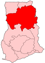
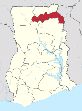
The Northern Region is one of the sixteen regions of Ghana. It is situated in the northern part of the country and ranks as the second largest of the sixteen regions. Before its division, it covered an area of 25,000 square kilometres, representing 10 percent of Ghana's area. In December 2018, the Savannah Region and North East Region were created from it. The Northern Region is divided into 16 districts. The region's capital is Tamale, Ghana's third largest city.

Bawku is a town and is the capital of the Bawku Municipal District, district in the Upper East region of north Ghana, adjacent to the border with Burkina Faso. It is located approximately between latitudes 11o 111 and 100 401 North and longitude 0o 181w and 0o 61 E in the north-eastern corner of the region. The municipality has a total land area of about 257 km2. The Municipality was established by Legislative Instrument (L.I) 2103. The municipality has a total land area of about 257 km2. Bawku has a 2021 settlement population of 119,458 people. Hon. Ayariga Mahama is the Member of Parliament for Bawku Central Constituency.

Yeji is a town in the centre of Ghana and the capital of the Pru East District of the Bono East Region in Ghana. Yeji is adjacent to Lake Volta. Yeji is connected by highway to Ejura and Kwadjokrom. It had a population of 29,515 at the census of 2010.
Tano South Municipal District is one of the six districts in Ahafo Region, Ghana. Originally it was formerly part of the then-larger Tano District in 1988, until the western part of the district was split off to create Tano North District in December 2004; thus the remaining part has been renamed as Tano South District. It was later elevated to municipal district assembly status in April 2018 to become Tano South Municipal District. The municipality is located in the eastern part of Ahafo Region and has Bechem as its capital town.

Ghana is a multilingual country in which about eighty languages are spoken. Of these, English, which was inherited from the colonial era, is the official language and lingua franca. Of the languages indigenous to Ghana, Akan is the most widely spoken in the south. Dagbani, Dagare, Sisaala, Waale, and Gonja are among the most widely spoken in the northern part of the country.
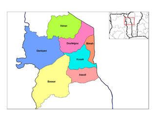
Dankpen is a prefecture located in the Kara Region of Togo. The prefecture covers 2 690 km2, with a population in 2022 of 185,662. The prefecture seat is located in Guérin-Kouka. It is split into 12 cantons, Guérin-Kouka, Bapuré, Nandouta, Kidjaboum, Namon, Nawaré, Katchamba, Nampoch, Natchiboré, Natchitikpi, Koulfièkou, and Koutchichéou.

Nanumba North Municipal District is one of the sixteen districts in Northern Region, Ghana. Originally it was formerly part of the then-larger Nanumba District in 1988, until the southern part of the district was split off to create Nanumba South District on 27 August 2004; thus the remaining part has been renamed as Nanumba North District. However on 15 March 2018, it was later elevated to municipal district assembly status to become Nanumba North Municipal District. The municipality is located in the southern part of Northern Region and has Bimbilla as its capital town.
Nanumba South District is one of the sixteen districts in Northern Region, Ghana. Originally it was formerly part of the then-larger Nanumba District in 1988, until the southern part of the district was split to off to create Nanumba South District on 27 August 2004; thus the remaining part has been renamed as Nanumba North District. The district assembly is located in the eastern part of Eastern Region and has Wulensi as its capital town.
Bimbilla is one of the constituencies represented in the Parliament of Ghana. It elects one Member of Parliament (MP) by the first past the post system of election. Bimbilla is located in the Nanumba North district of the Northern Region of Ghana. Hon. Dominic Nitiwul represent the constituency in the 3rd, 5th, 6th, 7th and 8th Parliament of the Fourth Republic of Ghana.
Wulensi is one of the constituencies represented in the Parliament of Ghana. It elects one pember of parliament (MP) by the first-past-the-post system of election. Wulensi is located in the Nanumba South district of the Northern Region of Ghana.
Kpandai District is one of the sixteen districts in Northern Region, Ghana. Originally it was formerly part of the then-larger East Gonja District in 1988, until the eastern part of the district was split off by a decree of president John Agyekum Kufuor on 29 February 2008 to create Kpandai District.; thus the remaining part has been retained as East Gonja Municipal District. The district assembly is located in the southern part of Northern Region and has Kpandai as its capital town.
Sekyere Central District is one of the forty-three districts in Ashanti Region, Ghana. Originally it was formerly part of the then-larger Sekyere West District in 1988, which was created from the former Sekyere District Council. However on 1 November 2007, the eastern part of the district was split off to create Sekyere Central District; while the remaining portion has since then been officially renamed as Mampong Municipal District, which it was elevated to municipal district assembly status on that same year. The district assembly is located in the northern part of Ashanti Region and has Nsuta as its capital town.
Walewale is one of the constituencies represented in the Parliament of Ghana. It elects one Member of Parliament (MP) by the [first past the post] / Simple Majority] system of election. Walewale is located in the West Mamprusi Municipal of the North East Region of Ghana. It is the Municipal capital of West Mamprusi Municipal Assembly. The constituency was formerly called the West Mamprusi Constituency.
Bimbilla is the capital town of Nanumba North District, a district in the Northern Region of Ghana. It is located in the East of the region, and is near the Oti River. The location is situated within the range of 8.5° north to 9.25° north latitude, and between 0.57° east to 0.5° east longitude. It borders five municipalities: Yendi Municipal to the north, Mion Municipal to the northwest, East Gonja Municipal to the west and southwest, Nanumba South Municipal to the south and east, and Zabzugu Municipal to the north-northeast.
Mion District is one of the sixteen districts in Northern Region, Ghana. Originally it was formerly part of the then-larger Yendi District in 1988, which was created from the former East Dagomba District Council, until the western part of the district was later split off to create Mion District on 28 June 2012; thus the remaining original part has bee retained to become Yendi Municipal District. The district assembly is located in the central part of Northern Region and has Sang as its capital town.

The Nanumba people are an ethnic group whose traditional homeland is in the southeast of the Northern Region of Ghana. They speak Nanugli, a Gur language.
The 1892 Sack of Salaga was a Gonja civil war for the control of the town of Salaga that occurred on December 5, 1892. A rebellion led by Kabachewura Isifa and assisted by his Dagomba and Nanumba allies overthrew Kpembewura Napo who died in exile in the same year.
Lungni is a village in the Northern region of Ghana, it is in the Wulensi District. Lungni is part of the territory of the Nanumbas a variant of the Dagomba ethnic group. The village over the years has had disputes regarding who provides candidates for the role of chieftaincy. To this extent the Nanumbas, Komkombas and Bassares have all laid claim to it. Lungni is sandwiched between Kpandae and wulensi. The inhabitants are predominantly farmers who grow yam and cereals. The village has a primary and junior secondary school but not a secondary school.
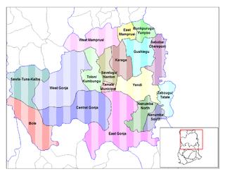
Nanumba District is a former district that was located in Northern Region, Ghana. Originally created as an ordinary district assembly in 1988. However on 27 August 2004, it was split off into two new districts: Nanumba North District and Nanumba South District. The district assembly was located in the southern part of Northern Region and had Bimbilla as its capital town.

