
Luxembourg is a small country located in the Low Countries, part of North-West Europe It borders Belgium for 148 kilometres to the west and north, France (23 km [14 mi]) to the south, and Germany (138 km [86 mi]) to the east. Luxembourg is landlocked, separated from the North Sea by Belgium.

Drôme is a department in Southeastern France, located in the Auvergne-Rhône-Alpes region. It is named after the Drôme River; it had a population of 508,006 as of 2016. Drôme's prefecture is Valence.
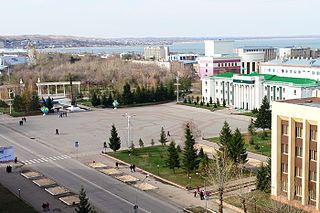
Kokshetau, formerly known as Kokchetav (1827–1993), is a city in northern Kazakhstan and the capital of Akmola Region, lying in the north of Kokshetau Uplands, on the southern shore of Lake Kopa and the southern edge of the Ishim Steppe. It is also situated at the junction of the Trans-Kazakhstan and South Siberian railways. Kokshetau lies at an elevation of approximately 234 m (768 ft) above sea level.

The Northern Region is one of the sixteen regions of Ghana. It is located in the north of the country and was the largest of the sixteen regions, covering an area of 70,384 square kilometres or 31 percent of Ghana's area until December 2018 when the Savannah Region and North East Region were created from it. The Northern Region is divided into 14 districts. The region's capital is Tamale.

Bolgatanga Municipal District is one of the fifteen districts in Upper East Region, Ghana. Originally created as an ordinary district assembly in 1988 when it was known as Bolgatanga District; which was established by Legislative Instrument (L.I.) 1438. Later, part of the district was split off by a decree of president John Agyekum Kufuor on August 2004 to create Talensi-Nabdam District; thus the original remaining part was upgraded to municipal district assembly status on the same year to become Bolgatanga Municipal District. Another part of the district was later split off to create Bolgatanga East District on 15 March 2018. The municipality is located in the central part of Upper East Region and has Bolgatanga as its capital town, which also serves as the capital of the Upper East Region.
New Juaben Municipal District is a former district that was located in Eastern Region, Ghana. Originally created as a municipal district assembly in 1988. However on 1 November 2017, it was split out into two new municipal districts: New Juaben South Municipal District and New Juaben North Municipal District. The municipality was located in the central part of Eastern Region and had Koforidua as its capital town.

Suhum/Kraboa/Coaltar District is a former district that was located in Eastern Region, Ghana. Originally created as an ordinary district assembly in 1988, which was created from the former Suhum-Kraboa-Coaltar District Council. However on 28 June 2012, it was split off into two new districts: Suhum Municipal District and Ayensuano District. The district assembly was located in the southern part of Eastern Region and had Suhum as its capital town.

West Mamprusi Municipal Assembly is one of the six districts in North East Region, Ghana. Originally created as an ordinary district assembly in 1988 when it was known as West Mamprusi District, which was created from the former Mamprusi District Council, until the western part of the district was split off on 28 June 2012 to create Mamprugu-Moagduri District; thus the remaining part has been retained as West Mamprusi District. However on 15 March 2018, it was elevated to municipal district assembly status to become West Mamprusi Municipal District. The municipality is located in the western part of North East Region and has Walewale as its capital town. Other settlements within the municipal assembly include Wulugu.
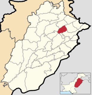
Hafizabad District is located in Punjab, Pakistan. Hafizabad was made a district in 1993; formerly, it was a tehsil of Gujranwala District. It is situated in central Punjab and is known for its rice industry on the agricultural side and rice industry on the industrial side and have top 5 exporters of rice from Pakistan. The capital of the district, Hafizabad, was built by the Rajpoot, known for strengthening the administration of Punjab.
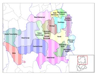
Gushegu Municipal District is one of the sixteen districts in Northern Region, Ghana. Originally it was formerly part of the then-larger Gushegu-Karaga District in 1988, which was created from the former East Dagomba District, until part of the district was split off create Karaga District on 27 August 2004; thus the remaining original part was renamed as Gushegu District. It was later upgraded to municipal district assembly status on that same year. The municipality is located in the northeast part of Northern Region and has Gushegu as its capital town.
Karaga District is one of the sixteen districts in Northern Region, Ghana. Originally it was formerly part of the then-larger Gushegu-Karaga District in 1988, which was created from the former East Dagomba District, until part of the district was split off create Karaga District on 27 August 2004; thus the remaining original part was renamed as Gushegu District. The district assembly is located in the northeast part of Northern Region and has Karaga as its capital town.

Builsa South is one of the constituencies represented in the Parliament of Ghana. It elects one Member of Parliament (MP) by the first past the post system of election. Builsa South is located in the Builsa district of the Upper East Region of Ghana.
Chereponi is one of the constituencies represented in the Parliament of Ghana. It elects one Member of Parliament (MP) by the first past the post system of election. Chereponi is located in the Chereponi district of the North East Region of Ghana.
Chereponi District is one of the six districts in North East Region, Ghana. Originally it was formerly part of the then-larger Saboba-Chereponi District in 1988, which was created from the former East Dagomba District Council, until the northern portion of the district was split off to become Chereponi District on 29 February 2008; thus the remaining part has been renamed as Saboba District. The district assembly is located in the southeast part of North East Region and has Chereponi as its capital town.
Chereponi is a small town and is the capital of Chereponi district, a district in the North East Region of Ghana.
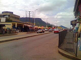
Saboba is a small town and is the capital of Saboba district, a district in the Northern Region of north Ghana. The primary economic activity is farming. Tribes like kokombas, kotokoli, kombas, chakosi and dagombas can be found in this district. Currently, Charles Bintin is the member of Parliament for Saboba and its neighbouring villages.

Shai Osudoku District is one of the twenty-nine districts in Greater Accra Region, Ghana. Originally it was formerly part of the then-larger Dangme West District in 1988, which was created from the former Dangme District Council, until the southern part of the district was split off to create Ningo-Prampram District on 28 June 2012; thus the remaining part has been renamed as Shai-Osudoku District. The district assembly is located in the eastern part of Greater Accra Region and has Dodowa as its capital town, which is about 39 km from the regional capital.
Keta Municipal District is one of the eighteen districts in Volta Region, Ghana. Originally created as an ordinary district assembly in 1988 when it was known as Keta District, which was created from the former Anlo District Council, until it was elevated to municipal district assembly status on 1 November 2007 to become Keta Municipal District. However on 19 February 2019, the western part of the district was split off to create Anloga District; thus the remaining part has been retained as Keta Municipal District. The municipality is located in the southeast part of Volta Region and has Keta as its capital town.

Saboba District is one of the sixteen districts in Northern Region, Ghana Originally it was formerly part of the then-larger Saboba-Chereponi District in 1988, which was created from the former East Dagomba District Council, until the northern part of the district was split off to create Chereponi District on 29 February 2008 ; thus the remaining part has been renamed as Saboba District. The district assembly is located in the northeast part of Northern Region and has Saboba as its capital town.
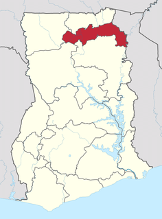
The North East Region is one of the sixteen regions of Ghana. It is located in the north of the country and was created in December 2018 after a referendum was voted upon to break it off of the Northern region. The region's capital is Nalerigu.


