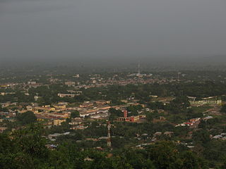
Ho is the capital of the Ho Municipal Assembly and the Volta Region of Ghana. The city lies between Mount Adaklu and Mount Galenukui or Togo Atakora Range, and is home to the Volta Regional Museum, a cathedral, and a prison. The city is the capital of unrecognised Western Togoland. It was formerly the administrative capital of British Togoland now part of the Volta Region. The population of Ho Municipality according to the 2010 Population and Housing Census is 177,281 representing 8.4 percent of the region's total population. Females constitute 52.7 percent and males represent 47.3 percent. The population in Ho grew up to 180,420 National Population Census. About 62 percent of the population resides in urban localities. The Municipality shares boundaries with Adaklu and Agotime-Ziope Districts to the South, Ho West District to the North and West and the Republic of Togo to the East. Its total land area is 2,361 square kilometers thus representing 11.5 percent of the region's total land area.
The Districts of Ghana are second-level administrative subdivisions of Ghana, below the level of region. There are currently 261 local metropolitan, municipal and district assemblies.

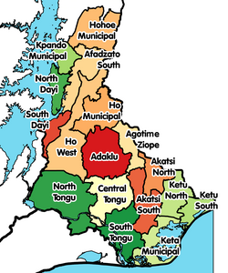
Volta Region is one of Ghana's sixteen administrative regions, with Ho designated as its capital. It is located west of Republic of Togo and to the east of Lake Volta. Divided into 25 administrative districts, the region is multi-ethnic and multilingual, including groups such as the Ewe, the Guan, and the Akan peoples. The Guan peoples include the Lolobi, Likpe, Akpafu, Akyode, Buem, Nyagbo, Avatime, and Nkonya. This region was carved out of the Volta Region in December 2018 by the New Patriotic Party. The people of the Volta Region are popularly known as Voltarians. This group includes the Ewes, Guans and other minor tribes living in the Volta Region. The people of the Volta Region are popular known for their rich cultural display and music some of which include Agbadza, Borborbor and Zigi.

Kpando Municipal District is one of the eighteen districts in Volta Region, Ghana. Originally created as an ordinary district assembly on 10 March 1989 when it was known as Kpando District, until the southern part of the district was split off by a decree of president John Agyekum Kufuor on 19 August 2004 to create South Dayi District; thus the remaining part has been retained as Kpando District. However on 28 June 2012, the southern part of the district was later split off to create North Dayi District on 28 June 2012; while the remaining part was elevated to municipal district assembly status on the same year to become Kpando Municipal District. The municipality is located in the western part of Volta Region and has Kpando as its capital town.
North Tongu District is one of the eighteen districts in Volta Region, Ghana. Originally it was formerly part of the then-larger and original North Tongu District on 10 March 1989, with Adidome as its capital town, which was created from the former Tongu District Council, until the western part of the district was split off to create a new North Tongu District on 28 June 2012, with Battor Dugame as its capital town, which was established by Legislative Instrument (L.I.) 2081; thus the remaining part has been renamed as Central Tongu District, with Adidome as its capital town, which was established by Legislative Instrument (L.I.) 2077. The district assembly is located in Addidome, near Adidome Senior High School (Adisec) the southwest part of Volta Region and has Battor Dugame as its capital town.
South Dayi District is one of the eighteen districts in Volta Region, Ghana. Originally it was formerly part of the then-larger Kpando District on 10 March 1989, until the southern part of the district was split off by a decree of president John Agyekum Kufuor on 19 August 2004 to create South Dayi District; thus the remaining part has been retained as Kpando District. The district assembly is located in the western part of Volta Region and has Kpeve as its capital town.

Adaklu-Anyigbe District is a former district that was located in Volta Region, Ghana. Originally it was formerly part of the then-larger Ho District on 10 March 1989, until the southern part was split off to create Adaklu-Anyigbe District on 13 August 2004; thus the remaining part has been retained as Ho Municipal District. However, on 28 June 2012, it was split off into two new districts: Agotime-Ziope District and Adaklu District. The district assembly was located in the central part of Volta Region and had Agortime-Kpetoe as its capital town.

Ho East is one of the constituencies represented in the Parliament of Ghana. It elects one Member of Parliament (MP) by the first past the post system of election. Ho East is located in the Adaklu-Anyigbe district of the Volta Region of Ghana.
Ho West is one of the constituencies represented in the Parliament of Ghana. It elects one Member of Parliament (MP) by the first past the post system of election. Ho West is located is in the Ho West District of the Volta Region of Ghana. Its capital is Dzolokpuita.

Adaklu is a town in the Adaklu District of Volta Region of Ghana. The town is known for the Adaklu Commercial Secondary School. The school is a second cycle institution.
Akatsi North District is one of eighteen districts in Volta Region, Ghana. Originally it was formerly part of the then-larger Akatsi District on 10 March 1989, which was created from the former Anlo District Council, until the northern part of the district was split off to create Akatsi North District on 28 June 2012; under the government by then-president John Atta Mills. thus the remaining part has been renamed as Akatsi South District. The district assembly is located in the southeast part of Volta Region and has Ave Dakpa as its capital town.
Akatsi South Municipal is one of eighteen districts in Volta Region, Ghana. Originally it was formerly part of the then-larger Akatsi District on 10 March 1989, which was created from the former Anlo District Council, until the northern part of the district was split off to create Akatsi North District on 28 June 2012; under the government by then-president John Atta Mills. Thus the remaining part has been renamed as Akatsi South District. The district assembly is located in the southeast part of Volta Region and has Akatsi as its capital town.
Ho Municipal Assembly is one of the 25 administrative Districts in the Volta Region, Ghana. It is made up of total land size of 2,361 km2 and a total estimated population of 213,960 in 2017, 105,195 being males and 108,765 are females. Originally created as an ordinary district assembly on 10 March 1989 when it was known as Ho District, until the southern part of the district was split off by a decree of president John Agyekum Kufuor on 13 August 2004 to create Adaklu-Anyigbe District; thus the remaining part has been retained as Ho District. However on 28 June 2012, the western part of the district was later split off to create Ho West District; thus the remaining part was elevated to municipal district assembly status on that same year to become Ho Municipal Assembly, which was established by Legislative Instrument (L.I.) 2074. The municipality is located in the central part of Volta Region and has Ho as its capital town.
Adaklu is one of the constituencies represented in the Parliament of Ghana. It elects one Member of Parliament (MP) by the first past the post system of election. Adaklu is located in the Adaklu district of the Volta Region of Ghana. It was created in 2012 by the Electoral Commission of Ghana prior to the Ghanaian general election.
Agotime-Ziope is one of the constituencies represented in the Parliament of Ghana. It elects one Member of Parliament (MP) by the first past the post system of election. Agotime-Ziope is located in the newly created Agotime Ziope district of the Volta Region of Ghana. It was created in 2012 by the Electoral Commission of Ghana prior to the Ghanaian general election.
Central Tongu District is one of the eighteen districts in Volta Region, Ghana. Originally created as an ordinary district assembly on 10 March 1989 when it was known as the first North Tongu District, with Adidome as its capital town, which was created from the former Tongu District Council, However on 28 June 2012, the western part of the district was split off to create a new North Tongu District, with Battor Dugame as its capital town, which was established by Legislative Instrument (L.I.) 2081; thus the remaining part has been renamed as Central Tongu District, with Adidome as its capital town, which was established by Legislative Instrument (L.I.) 2077. The district assembly is located in the southwest part of Volta Region and has Adidome as its capital town.
Agotime-Ziope District is one of the eighteen districts in Volta Region, Ghana. Originally it was formerly part of the then-larger Adaklu-Anyigbe District on 13 August 2004, until the western part of the district was split off to create Adaklu District on 28 June 2012; thus the remaining part has been renamed as Agotime-Ziope District. The district assembly is located in the central part of Volta Region and has Agortime-Kpetoe as its capital town.
Ho West District is one of the eighteen districts in Volta Region, Ghana. Originally it was formerly part of the then-larger Ho District on 10 March 1989, until the western part was split off to create Ho West District on 28 June 2012; thus the remaining part was elevated to municipal district assembly status on that same year to become Ho Municipal District. The district assembly is located in the central part of Volta Region and has Dzolokpuita as its capital town.
Adaklu Waya is the capital of the Adaklu District. It is one of the districts of the Volta Region, Ghana.
The R28 Regional Highway is a highway in the Volta Region of Ghana. It starts in the south from Sogakope through Ho the regional capital to Fume at its northern end. The total length is one hundred and seventeen (117) kilometres.