Akatsi

Last updated

Akatsi
Mornenu
District capital
Akatsi - Dzodze - Aflao Road pano.jpg
Aerial view of roads leading to Accra, Dzodze and Aflao (from left)
Ghana adm location map.svg
Red pog.svg
Akatsi
Location in Ghana
Coordinates: 06°07′51.68″N00°47′53.56″E / 6.1310222°N 0.7982111°E / 6.1310222; 0.7982111
Country Flag of Ghana.svg Ghana
Region Volta Region
District Akatsi South District
Time zone GMT
  Summer (DST) GMT
Area code 0966

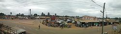
Akatsi is a small town and is the capital of Akatsi South District, a district in the Volta Region of Ghana. [1]

Contents

Economy

Economic activities in Akatsi are mainly Subsistence agriculture coupled with vibrant buying and selling. Smuggling of clothing from Lomé in Togo through Aflao (the south-eastern border town of Ghana) to Accra.[ citation needed ] The trans-West Africa highway linking Lomé to Accra through Akatsi also aids an active male dominated transportation business in Akatsi.

Demographics

The inhabitants of Akatsi are Avenor Ewes and the main language of any social and economic interaction is Ewe. The Ewe settled in the area after the exodus of Ewe tribe from Notsie in Togo to this area in the seventeenth century.

Education

Akatsi is home to the teacher training educational institution Akatsi College of Education, which includes over 700 students and has achieved a good reputation in the area for educating tutors.

Climate

Climate data for Akatsi (1991–2020)
MonthJanFebMarAprMayJunJulAugSepOctNovDecYear
Record high °C (°F)38.0
(100.4)
38.7
(101.7)
37.8
(100.0)
38.0
(100.4)
37.5
(99.5)
36.0
(96.8)
34.2
(93.6)
36.6
(97.9)
34.7
(94.5)
35.5
(95.9)
36.0
(96.8)
36.0
(96.8)
38.7
(101.7)
Average high °C (°F)34.0
(93.2)
35.0
(95.0)
34.4
(93.9)
33.7
(92.7)
32.5
(90.5)
30.5
(86.9)
29.4
(84.9)
29.5
(85.1)
30.8
(87.4)
31.9
(89.4)
33.0
(91.4)
33.5
(92.3)
32.4
(90.3)
Daily mean °C (°F)28.7
(83.7)
29.9
(85.8)
29.7
(85.5)
29.3
(84.7)
28.4
(83.1)
27.0
(80.6)
26.2
(79.2)
26.1
(79.0)
27.0
(80.6)
27.7
(81.9)
28.4
(83.1)
28.7
(83.7)
28.1
(82.6)
Average low °C (°F)23.5
(74.3)
24.8
(76.6)
25.0
(77.0)
24.8
(76.6)
24.3
(75.7)
23.6
(74.5)
23.0
(73.4)
22.5
(72.5)
23.1
(73.6)
23.4
(74.1)
23.8
(74.8)
23.7
(74.7)
23.8
(74.8)
Record low °C (°F)18.0
(64.4)
18.3
(64.9)
20.0
(68.0)
20.5
(68.9)
20.4
(68.7)
20.4
(68.7)
19.5
(67.1)
19.5
(67.1)
20.5
(68.9)
20.0
(68.0)
19.5
(67.1)
17.0
(62.6)
17.0
(62.6)
Average precipitation mm (inches)13.5
(0.53)
25.6
(1.01)
83.7
(3.30)
94.2
(3.71)
176.2
(6.94)
153.5
(6.04)
56.2
(2.21)
31.6
(1.24)
91.0
(3.58)
120.2
(4.73)
73.4
(2.89)
28.8
(1.13)
947.9
(37.32)
Average precipitation days (≥ 1.0 mm)1.02.24.85.39.59.54.83.37.38.86.52.365.3
Source: NOAA [2]

Related Research Articles

<span class="mw-page-title-main">Togo</span> Country in West Africa

Togo, officially the Togolese Republic, is a country in West Africa. It is bordered by Ghana to the west, Benin to the east and Burkina Faso to the north. It is one of the least developed countries and extends south to the Gulf of Guinea, where its capital, Lomé, is located. It is a small, tropical country, which covers 56,785 square kilometres and has a population of approximately 8 million, and has a width of less than 115 km (71 mi) between Ghana and its eastern neighbor Benin.

<span class="mw-page-title-main">Accra</span> Capital and the largest city of Ghana

Accra is the capital and largest city of Ghana, located on the southern coast at the Gulf of Guinea, which is part of the Atlantic Ocean. As of 2021 census, the Accra Metropolitan District, 20.4 km2 (7.9 sq mi), had a population of 284,124 inhabitants, and the larger Greater Accra Region, 3,245 km2 (1,253 sq mi), had a population of 5,455,692 inhabitants. In common usage, the name "Accra" often refers to the territory of the Accra Metropolitan District as it existed before 2008, when it covered 199.4 km2 (77.0 sq mi). This territory has since been split into 13 local government districts: 12 independent municipal districts and the reduced Accra Metropolitan District (20.4 km2), which is the only district within the capital to be granted city status. This territory of 199.4 km2 contained 1,782,150 inhabitants at the 2021 census, and serves as the capital of Ghana, while the district under the jurisdiction of the Accra Metropolitan Assembly proper (20.4 km2) is distinguished from the rest of the capital as the "City of Accra".

<span class="mw-page-title-main">Lomé</span> Capital, chief port, and the largest city of Togo

Lomé is the capital and largest city of Togo. It has an urban population of 837,437 while there were 1,477,660 permanent residents in its metropolitan area as of the 2010 census. Located on the Gulf of Guinea at the southwest corner of the country, with its entire western border along the easternmost point of Ghana's Volta Region, Lomé is the country's administrative and industrial center, which includes an oil refinery. It is also the country's chief port, from where it exports coffee, cocoa, copra, and oil palm kernels.

<span class="mw-page-title-main">Hilla Limann</span> Ghanaian diplomat and politician

Hilla Limann, was a Ghanaian diplomat and politician who served the President of Ghana from 24 September 1979 to 31 December 1981. He served as a diplomat in Lomé, Togo and Geneva, Switzerland.

<span class="mw-page-title-main">Ewe people</span> West African ethnic group

The Ewe people are a Gbe-speaking ethnic group. The largest population of Ewe people is in Ghana, and the second largest population is in Togo. They speak the Ewe language which belongs to the Gbe family of languages. They are related to other speakers of Gbe languages such as the Fon, Gen, Phla Phera, Gun, Maxi, and the Aja people of Togo, Benin and southwestern Nigeria.

<span class="mw-page-title-main">Volta Region</span> Region of Ghana

Volta Region is one of Ghana's sixteen administrative regions, with Ho designated as its capital. It is located west of Republic of Togo and to the east of Lake Volta. Divided into 25 administrative districts, the region is multi-ethnic and multilingual, including groups such as the Ewe, the Guan, and the Akan peoples. The Guan peoples include the Lolobi, Likpe, Akpafu, Buem, and Nkonya people. This region was carved out of the Volta Region in December 2018 by the New Patriotic Party. The people of the Volta Region are popularly known as Ewes. The people of the Volta Region are popular known for their rich cultural display and music some of which include Agbadza, Borborbor and Zigi.

Mount Afadja, known as Afadjato to the Ewe people of Ghana and Togo, is one of the highest mountains in Ghana. The summit is located in the Volta Region, near the border with Togo, close to the villages of Liati Wote and Gbledi Gbogame in the Afadjato South District and Hohoe Municipality, respectively. It is about 178 kilometers (111 mi) northeast of Accra, and 178 kilometers (111 mi) northwest of Lomé. Part of the Agumatsa sub-range of the West Africa Mountains, its summit is 885 metres (2,904 ft) above sea level. The summit of Mount Aduadu lies 3.5 kilometers (2 mi) to the east.

<span class="mw-page-title-main">Aflao</span> Town in Volta Region, Ghana

Aflao is a town in Ketu South District in the Volta Region on Ghana's border with Togo. Aflao is the twenty-eighth most populous settlement in Ghana, in terms of population, with a population of 96,550 people.

<span class="mw-page-title-main">Dangme East District</span> Former District in Ghana

Dangme East District is a former district that was located in Greater Accra Region, Ghana. Originally created as an ordinary district assembly in 1988, which was created from the former Dangme District Council. However on 28 June 2012, it was split off into two new districts: Ada East District and Ada West District. The district assembly was located in the eastern part of Greater Accra Region and had Ada Foah as its capital town.

<span class="mw-page-title-main">Languages of Ghana</span>

Ghana is a multilingual country in which about eighty languages are spoken. Of these, English, which was inherited from the colonial era, is the official language and lingua franca. Of the languages indigenous to Ghana, Akan is the most widely spoken in the south. Dagbani is most widely spoken in the north.

The Kpalime Traditional Area is located mainly in the South Dayi District of the Volta Region of Ghana. This area originally was located partly within the Kpando District of the Volta Region but with the creation of new districts in 2004, it now falls within the South Dayi District.

<span class="mw-page-title-main">Ghana–Togo relations</span> Bilateral relations

The strains in Ghana–Togo relations stretch back to pre-independence days.

Dzodze is a small town, the capital and administrative centre of Ketu North Municipality, a district in the south eastern corner of the Volta Region of Ghana. From the Exodus of the Ewe people, some of them arrived and stayed in Dzodze, in the Volta Region of Ghana after the fall of the wall of Notse. The natives speak Ewe (Eʋe) the main language in Dzodze. They are an Anlo-Ewe community. The traditional rhythm of this land is Agbadja, and Ageshe.

Wegbe Kpalime is a village located in the South Dayi District of the Volta Region of Ghana.

Adidome is a small town and is the capital of Central Tongu district, a district in the Volta Region of Ghana. According to the Ghana Statistical Service 2010 Population and Housing Census, the population of Adidome was 7,587. The distance from Adidome to Ghana's capital, Accra is approximately 144 km. The town has a Senior High School called Adidome Senior High School. Adidome is not only noted for its Senior High School but also the Adidome Farm Institute.

<span class="mw-page-title-main">Avenor Ewe</span> Ethnic groups in Ghana

The Avenor Ewe are a sub-tribe of the Ewe people of Ghana. The origin of the name Avenor is not known.

<span class="mw-page-title-main">North German Missionary Society</span>

The North German Missionary Society or North German Mission is a Presbyterian Christian organisation based in Bremen formed on 19 April 1836 to unify missionary work in North Germany. The society has also been active among the Ewes in southeastern Gold Coast, now Ghana. The mission was engaged in New Zealand and India prior to concentrating its activities in Ghana from 1847.

The N1 or National Highway 1 is a national highway in Ghana that begins at the border with Ivory Coast at Elubo and runs through Sekondi-Takoradi, Cape Coast, Winneba, Accra and Tema to the border with Togo at Aflao. It is the main highway along the coast of the country, with a total distance of 540 kilometers. The route runs through the Western, Central, Greater Accra and Volta regions of Ghana.

To Kpalime or To is a village located in the South Dayi District of the Volta Region of Ghana. It is one of the towns of the Kpalime Traditional Area.

Kpaleis a village located in the Ho West District of the Volta Region of Ghana. It is one of the towns of the Kpalime Traditional Area.

References

  1. "Akatsi District". Archived from the original on 2012-05-11. Retrieved 2012-07-15.
  2. "Akatsi Normals 1991–2020". World Meteorological Organization Climatological Standard Normals (1991–2020). National Oceanic and Atmospheric Administration. Archived from the original on 28 September 2023. Retrieved 28 September 2023.