
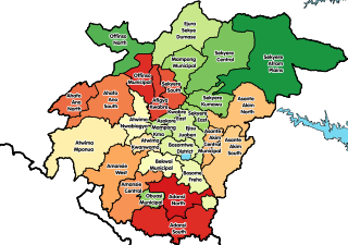
The Ashanti Region is located in southern part of Ghana and it is the third largest of 16 administrative regions, occupying a total land surface of 24,389 km2 (9,417 sq mi) or 10.2 percent of the total land area of Ghana. In terms of population, however, it is the most populated region with a population of 4,780,380 according to the 2011 census, accounting for 19.4% of Ghana's total population. The Ashanti Region is known for its major gold bar and cocoa production. The largest city and regional capital is Kumasi.

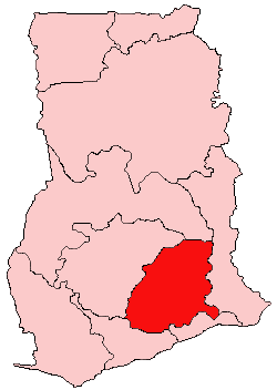
The Eastern Region is located in south Ghana and is one of the sixteen administrative regions of Ghana. Eastern region is bordered to the east by the Lake Volta, to the north by Bono East Region and Ashanti region, to the west by Ashanti region, to the south by Central region and Greater Accra Region. Akans are the dominant inhabitants and natives of Eastern region and Akan, Ewe, Krobo, Hausa and English are the main spoken languages. The capital town of Eastern Region is Koforidua.The Eastern region is the location of the Akosombo dam and the economy of the Eastern region is dominated by its high-capacity electricity generation. Eastern region covers an area of 19,323 square kilometres, which is about 8.1% of Ghana's total landform.

Akim Oda is a town in the Eastern Region of south Ghana and is the capital of the Birim Central Municipal District and the traditional capital of Akyem Kotoku. In 2013, Akim Oda had a settlement population of 60,604 people.
Kwahu refers to an area and group of people that live in Ghana and are part of the Twi-speaking Akan group. The area has been dubbed Asaase Aban, or the Natural Fortress, in view of its position as the highest habitable elevation in the country. Kwahu lies in the Eastern Region of Ghana, on the west shore of Lake Volta. The Kwahus share the Eastern Region with their fellow Akans: the Akyem and Akuapem, as well as the Adangbe-Krobos. A significant migrant population from the Northern and Volta Regions and some indigenous Guans from the bordering Oti and Brong East Regions live in the Afram Plains area. They work as traders, farm-hands, fisherfolk, and caretakers in the fertile waterfront 'melting pot'.
Asamankese is a town in south Ghana and is the capital of West Akim Municipal District, a district in the Eastern Region of south Ghana. Asamankese has a 2013 settlement population of approximately 39,435 people. Asamankese is on the main highway to Kumasi and Accra in the interior.
Articles related to Ghana include:

The Akyem are an Akan people. The term Akyem is used to describe a group of four states: Asante Akyem, Akyem Abuakwa, Akyem Kotoku and Akyem Bosome. These nations are located primarily in the eastern region in south Ghana. The term is also used to describe the general area where the Akyem ethnic group clusters. The Akyem ethnic group make up between 3-4 percent of Ghana's population depending on how one defines the group and are very prominent in all aspects of Ghanaian life. The Akyem are a matrilineal people. The history of this ethnic group is that of brave warriors who managed to create a thriving often influential and relatively independent state within modern-day Ghana. When one talks of Ghanaian history, there is often mention of The Big Six. These were six individuals who played a big role in the independence of Ghana. Of the big six, people of Akyem descent made up the majority.
The Big Six were six leaders of the United Gold Coast Convention (UGCC), one of the leading political parties in the British colony of the Gold Coast, known after independence as Ghana. They were detained by the colonial authorities in 1948 following disturbances that led to the killing of three World War II veterans. They are pictured on the front of the Ghana cedi notes.
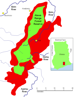
The Atewa Range Forest Reserve is in the Akyem Abuakwa region of southeastern Ghana, near the town of Kibi, and south-west of the Kwahu Plateau which forms the south-west boundary of Lake Volta. The range runs roughly north–south, consisting of steep-sided hills with fairly flat summits. It is the last remains of the Cenozoic peneplain that once covered southern Ghana, and contains ancient bauxitic soils. The range is the site of an important forest reserve, and the source of three major rivers.
Kwaku Boateng was a Ghanaian barrister, politician, Christian evangelist and cabinet minister.
Akuapim-Mampong is a town in the Akuapim North district of the Eastern Region of Ghana. It shares boundaries with Mamfe .It is famous for being the first place cocoa was planted in Ghana by Tetteh Quarshie
Amanokrom is a town in the Akuapim North District of the Eastern Region of Ghana. It shares border with Mamfe and Abotakyi
Abiriw is a town in the Okere District Assembly in the Eastern Region of Ghana.It shares border with Akropong and Dawu.
Nana Kuntunkunuku II was a traditional ruler in Ghana and Paramount Chief of Akyem-Abuakwa in the Eastern Region. His official title was Okyehene - King of Akyem. He was the seventh president of the National House of Chiefs and served from 1998 to 1999. He succeeded Nana Ofori Atta III who was his uncle and ruled the Akyems for 23 years. He was succeeded by Nana Amoatia Ofori Panin II.

Johann Gottlieb Christaller was a German missionary, clergyman, ethnolinguist, translator and philologist who served with the Basel Mission. He was devoted to the study of the Twi language in what was then the Gold Coast, now Ghana. He was instrumental, together with African colleagues, Akan linguists, David Asante, Theophilus Opoku, Jonathan Palmer Bekoe, and Paul Keteku in the translation of the Bible into the Akuapem dialect of Twi. Christaller was also the first editor of the Christian Messenger, the official news publication of the Basel Mission, serving from 1883 to 1895. He is recognised in some circles as the "founder of scientific linguistic research in West Africa".
David Asante was a philologist, linguist, translator and the first Akan native missionary of the Basel Evangelical Missionary Society. He was the second African to be educated in Europe by the Basel Mission after the Americo-Liberian pastor, George Peter Thompson. Asante worked closely with the German missionary and philologist, Johann Gottlieb Christaller and fellow native linguists, Theophilus Opoku, Jonathan Palmer Bekoe, and Paul Staudt Keteku in the translation of the Bible into the Twi language.
Paul Kwabena Boafo is a Ghanaian theologian and minister who was elected as the twelfth Presiding Bishop of the Methodist Church Ghana in 2018. He previously served as the Administrative Bishop of the Church. He is the first ordained minister to serve in both capacities in the episcopal history of the Ghanaian Methodist Church. Boafo also served as the Protestant Chaplain of the Kwame Nkrumah University of Science and Technology (KNUST).
Robert Yaw Addo Fening is a Ghanaian historian who has made major contributions in documenting the history of Akyem Abuakwa and of Ghana. He has been accorded the title Okyeman Kanea in recognition of his historical works. For several years he taught at the University of Ghana.
Nana Amoako Atta I,, was the paramount chief of Akyem Abuakwa in nineteenth century southern Ghana. Locally, his position is known as the Okyehene or Omanhene. He ruled the traditional kingdom from July 1866 to 1880 and from 1885 to 1887. After the Sagrenti War of 1874, the British declared Akyem Abuakwa a colonial possession, legally called a ‘protectorate’, as part of the Gold Coast. This development led to a clash between the old traditional Akan culture and the imposition of the new Western Christian political order.
Old Tafo Municipal District is one of the forty-three districts in Ashanti Region, Ghana. Originally it was a sub-metropolitan district council within the Kumasi Metropolitan Assembly until 15 March 2018, when it was elevated to municipal district assembly status to become Old Tafo Municipal District. The municipality is located in the central part of Ashanti Region and has Tafo as its capital town.
