Bouna is a town in north-eastern Ivory Coast. It is a sub-prefecture of and the seat of Bouna Department. It is also the seat of Bounkani Region in Zanzan District and a commune.
Begho was a city located in Ghana, located just south of its successor community, Hani.

The Soninke (Sarakolleh) people are a West African Mande-speaking ethnic group found in Mali, southern Mauritania, eastern Senegal, The Gambia, and Guinea. They speak the Soninke language, also called the Serakhulle or Azer language, which is one of the Mande languages. Soninke people were the founders of the ancient empire of Ghana or Wagadou c. 200–1240 CE, Subgroups of Soninke include the Jakhanke, Maraka and Wangara. When the Ghana empire was destroyed, the resulting diaspora brought Soninkes to Mali, Mauritania, Senegal, Gambia, Burkina Faso, Côte d'Ivoire, Guinée-Conakry, modern-day Republic of Ghana, Kano in Nigeria, and Guinea-Bissau where some of this trading diaspora was called Wangara, leading to the saying “when Americans landed on the moon, a Soninke was already there” in Senegal, with other versions across West Africa.

Bondoukou is a city in northeastern Ivory Coast, 420 km northeast of Abidjan. It is the seat of both Zanzan District and Gontougo Region. It is also a commune and the seat of and a sub-prefecture of Bondoukou Department.
al-Hajj Mahmadu Lamine Drame,also known as Ma Lamine Demba Dibassi, was a nineteenth-century Tijani marabout who led a series of rebellions against the French colonial government in what is now Senegal.
The Wangara are a diaspora community of ethnic Soninke origin who served as specialized long-distance merchants throughout West Africa, particularly in Trans-Saharan trade. Originating from the Ghana Empire, over time the Wangara became integrated into numerous other communities and ethnic groups, particularly in Timbuktu, Agadez, Kano, Gao, Salaga, Kong, Bissa, Kankan, Fouta Jallon, Djenné as well as Bambouk, Bure, Lobi, and Bono goldfields and Borgu. They were practicing Muslims who helped spread the religion widely and served as clerics, political advisors, healers and marabouts, often following the Suwarian Tradition.
Touré is the French transcription of a West African surname. The name is probably derived from tùùré, the word for 'elephant' in Soninké, the language of the Ghana Empire. The clan existed as kings of Zaghari on the middle Niger before the Moroccan invasion of Ghana. A theory of their origin holds that the Touré are descended from the "Roum," pre-Arab North African soldiers, and local women.

Vohemar is a coastal city and a municipality in northern Madagascar. It belongs to the district of Iharana, which is a part of Sava Region. It had a population of 22047 in 2018.

Kong, also known as Kpon, is a town in northern Ivory Coast. It is a sub-prefecture of and the seat of Kong Department in Tchologo Region, Savanes District. Kong is also a commune. It was the capital of the Kong Empire (1710–1895).
Mohammed Bagayogo Es Sudane Al Wangari Al Timbukti was an eminent scholar from Timbuktu, Mali. Baghayogho originated from among the Juula people, who are a Mande ethnic group composed of merchants and scholars.
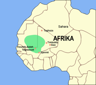
The Ghana Empire, also known as simply Ghana, Ghanata, or Wagadu, was a West African classical to post-classical era western-Sahelian empire based in the modern-day southeast of Mauritania and western Mali.
Moussadou or Moussadougou is a town and sub-prefecture in the Beyla Prefecture in the Nzérékoré Region of south-eastern Guinea.
The Anufo or Chakosi are an Akan people who live in the Dapaong and (Sansanné-)Mango areas of Togo, as well as in Ghana. They trace their origin to a place called Anou or Ano on the Komoé River in the Ivory Coast. Thus, they refer to themselves Anoufou "people of Anu". The exonym Chakosi has also been spelled 'Chokossi', 'Chakossi', 'Kyokosi', 'Kyokoshi', 'Tschokossi', and 'Tyokossi'. They migrated to their present location in the late 18th century. The Anufo had their own kingdom based in Sansanné-Mango, prior to German colonization of Togo. As of 2003 they had a combined population of 137,600. They speak the Anufo language, one of the Akan languages.
Ankaful is a town in the Central Region of Ghana. It is under the jurisdiction of the Cape Coast Metropolitan Assembly. The town is known for three things:

Kintampo is a town and tourist destination in the Bono East Region of Ghana. It became the capital of Kintampo North Municipal in 2004. Kintampo has a population of 111 000. It also served as the capital of the former Kintampo District. Kintampo also has Senior High Schools (KINSS) which is located at Kyeremankoma, has participated in the National Science Quiz on numerous occasions. Modern Senior High School (MODESS). Kintampo Technical Institute- KINTECH and Centre College Senior High School. There is a College of Health, The Kintampo College of Health and Well-being (CoHK) in the town, which is proposed to become a full fledge University. Most of the population in Kintampo are farmers, with production focused on yams, maize, legumes, tubers and other vegetables. The main ethnicity of Kintampo are the Bono people. There are other settler tribes including the Wangara, Grushi, Grumah, Konkomba, Mo, Frafra and the others.
Kabara is a small town in Mali on the Niger River, the port for Timbuktu. It is 8 km (5 mi) to the south of Timbuktu and is connected to an arm of the Niger River by a 3 km (2 mi) canal. The town has at times in the past been linked to Timbuktu by an extension of the canal. However, silting and lower water levels in recent years have made the extension canal unusable and the Kabara port usable only during the high water seasons.
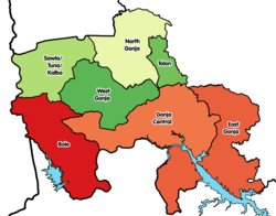
The Savannah Region is one of the newest regions of Ghana and yet the largest region in the country. The creation of the Region follows presentation of a petition by the Gonja Traditional Council, led by the Yagbonwura Tumtumba Boresa Jakpa I. Upon receiving favourable responses from all stakeholders in the Northern Region, the Brobbey Commission, a referendum was conducted on the 27th December 2018. The result was a resounding yes of 99.7%. The President of the Republic of Ghana signed and presented the Constitutional Instrument (CI) 115 to the Yagbonwura in the Jubilee House, Accra on 12 February 2019. The launch was well attended by sons and daughters of Gonjaland including all current and past Mps, MDCEs and all appointees with Gonjaland descent. Damongo was declared the capital of the new Savannah Region. It is located in the north of the country. The Savannah Region is divided into 7 districts; Bole, Central Gonja, North Gonja, East Gonja, Sawla/Tuna/Kalba, West Gonja, North East Gonja and 7 Constituencies; Bole/Bamboi, Damongo, Daboya/Mankarigu, Salaga North, Salaga South, Sawla/Tuna/Kalba and Yapei/Kusawgu. The capital of Bole district is Bole; East Gonja municipal is Salaga; West Gonja district is Damango; Sawla Tuna Kalba district is Salwa; Central Gonja is Buipe; North Gonja is Daboya; and North East Gonja is Kpalbe
Bole Senior High School is a second cycle school in Bole in the Bole District in the Savannah Region of Ghana. The current headmasters are Mr Albertos Mahama and Reverend Father Corlenius Begua Termaghre.

Asankrangwa Senior High School is a second cycle institution located in Asankragwa in the Wassa Amenfi West District in the Western Region of Ghana.
Diarra, also referred to as Kingui, Diafunu, or Kaniaga, was a Soninke state in what is now northwestern Mali, centered around the town of Diarra. Founded in the 11th century, it was occasionally independent but frequently under the domination of a series of Sahelian empires until its final destruction by the Toucouleur Empire in the 19th century.