The Western region is located in south Ghana, spreads from the Ivory Coast in the west to the Central region in the east, includes the capital and large twin city of Sekondi-Takoradi on the coast, coastal Axim, and a hilly inland area including Elubo. It includes Ghana's southernmost location, Cape Three Points, where crude oil was discovered in commercial quantities in June 2007. The region covers an area of 13,842 km2, and had a population of 2,060,585 at the 2021 Census. It has a coastline that stretches from South Ghana's border with Ivory Coast to the it's boundary with the Central region on the east.

The regions of Ghana are the first level of subnational government administration within the Republic of Ghana. As of 2020, there are 16 regions, which are further divided for administrative purposes into 260 local metropolitan, municipal and district assemblies.
The Districts of Ghana are second-level administrative subdivisions of Ghana, below the level of region. There are currently 261 local metropolitan, municipal and district assemblies.

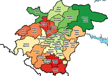
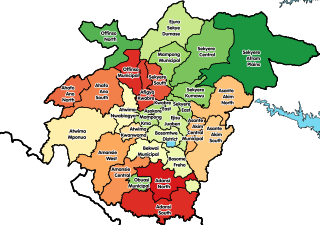
The Ashanti Region is located in the southern part of Ghana and is the third largest of 16 administrative regions, occupying a total land surface of 24,389 km2 (9,417 sq mi) and making up 10.2 percent of the total land area of Ghana. It is the most populated region in Ghana, with a population of 5,440,463 according to the 2021 census, accounting for around one-sixth of Ghana's total population. The Ashanti Region is known for its gold bar and cocoa production. The largest city and capital of Ashanti is Kumasi.
Ahafo Ano North Municipal District is one of the forty-three districts in Ashanti Region, Ghana. Originally created as an ordinary district assembly in 1988 as Ahafo Ano North District, which was created from the former Ahafo Ano District Council; until it was elevated to municipal district assembly status to become Ahafo Ano North Municipal District in November 2017. The municipality is located in the western part of Ashanti Region and has Tepa as its capital town.
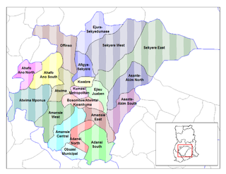
Ahafo Ano South District is a former district that was located in Ashanti Region, Ghana. Originally created as an ordinary district assembly in 1988, which was created from the former Ahafo Ano District Council. However, on 15 March 2018, it was split off into two new districts: Ahafo Ano South West District and Ahafo Ano South East District. The district assembly was located in the western part of Ashanti Region and had Mankranso as its capital town.
Kumasi Metropolitan Assembly is one of the 261 Metropolitan, Municipal and District Assemblies (MMDAs) in Ghana. It forms part of the forty-three districts in Ashanti Region, Ghana with Kumasi being its administrative capital. The metropolis is located in the central part of Ashanti Region and has Kumasi as its capital city. With a projected population of over two million and an annual growth rate of about 5.4%, it is a rapidly expanding metropolis. The Metropolis is about 254 kilometers long, with a centrally located commercial area and a largely circular physical structure. The fast rate of urbanization is confirmed by estimates that 48%, 46%, and 60% of the Metropolis are rural, peri-urban, and urban, respectively.
Nkoranza is a town located in the mid-north of Ghana. It is the district capital of the Nkoranza District in the Bono East Region.

Ahafo Ano South is one of the constituencies represented in the Parliament of Ghana. It elects one Member of Parliament (MP) by the first past the post system of election. Ahafo Ano South is located in the Ahafo Ano South district of the Ashanti Region of Ghana.
Asunafo North Municipal District is one of the six districts in Ahafo Region, Ghana. It was formerly part of the then-larger Asunafo District from 1988 until the southern part of the district was split off by a decree of president John Agyekum Kufuor on 12 November 2003 to become Asunafo South District. The remaining northern part was renamed as Asunafo North District which was later elevated to municipal status on 29 February 2008 to become Asunafo North Municipal District. The municipality is located in the western part of Ahafo Region and has Goaso as its capital town.

The Ahafo Region is a newly created region in Ghana with Goaso as its capital. The region has administrative and governmental legislature like all the ten already existing regions in Ghana. The region was carved out of the south-eastern part of the Brong Ahafo Region and was in fulfillment of a campaign promise made by New Patriotic Party. Prior to the 2016 Ghanaian general election, the then candidate Nana Akufo-Addo declared that when elected, he would explore the possibility of creating new regions out of some of the existing regions in Ghana in order to bring government closer to citizens.

Suleman Adamu Sanid is a Ghanaian politician and member of the Seventh Parliament of the Fourth Republic of Ghana and the 8th Parliament of the Fourth Republic of Ghana, representing the Ahafo Ano North Constituency in the Ashanti Region on the ticket of the New Patriotic Party.
Samuel Kwadwo Yamoah is a Ghanaian politician and was a member of the first parliament of the fourth Republic representing the Ahafo Ano North constituency in the Ashanti Region. He represented the National Democratic Congress.
Suame Municipal District is one of the forty-three districts in Ashanti Region, Ghana. Originally it was a sub-metropolitan district council within the Kumasi Metropolitan Assembly until 15 March 2018, when it was elevated to municipal district assembly status to become Suame Municipal District. The municipality is located in the central part of Ashanti Region and has Suame as its capital town.
Oforikrom Municipal District is one of the forty-three districts in Ashanti Region, Ghana. Originally it was a sub-metropolitan district council within the Kumasi Metropolitan Assembly until 15 March 2018, when it was elevated to municipal district assembly status to become Oforikrom Municipal District. The municipality is located in the central part of Ashanti Region and has Oforikrom as its capital town.
Kwadaso Municipal District is one of the forty-three districts in Ashanti Region, Ghana. Originally it was a sub-metropolitan district council within the Kumasi Metropolitan Assembly until 15 March 2018, when it was elevated to municipal district assembly status to become Kwadaso Municipal District. The municipality is located in the central part of Ashanti Region and has Kwadaso as its capital town.
Ahafo Ano South East District is one of the forty-three districts in Ashanti Region, Ghana. Originally it was formerly part of the then-larger Ahafo Ano South District in 1988, which was created from the former Ahafo Ano District Council, until part of the district was split off to create Ahafo Ano South East District on 15 March 2018; thus the remaining part has been renamed as Ahafo Ano South West District. The district assembly is located in the western part of Ashanti Region and has Adugyama as its capital town.
Adansi Asokwa is the capital of the Adansi Asokwa District in the Ashanti Region of Ghana. The district itself was created out of the Adansi North District by Legislative Instrument in 2018. It is located in the southern half of the region on the N8 highway running from Kumasi, capital of the region to Yamoransa near Cape Coast, capital of the Central Region. It is also the main town in the Asokwa Area Council, one of four in the district.
Ntotroso is a town in the Asutifi North District in the Ahafo Region of Ghana. The distance from Ntotroso to Kenyasi, the District capital is 13 km while that of Sunyani, the Bono regional capital is 41 km. Notable tertiary institution in this town, is the Ntotroso Nursing college.
Adugyama is a town and is the capital of Ahafo Ano South East District in the Ashanti Region of Ghana. It is about 42 km north-west of Kumasi