
Ghana is a West African country in Africa, along the Gulf of Guinea.

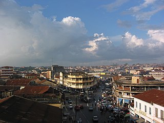
Kumasi is a city in the Ashanti Region, and is among the largest metropolitan areas in Ghana. Kumasi is located in a rain forest region near Lake Bosomtwe, and is the commercial, industrial, and cultural capital of the historical Ashanti Empire. Kumasi is approximately 500 kilometres (300 mi) north of the Equator and 200 kilometres (100 mi) north of the Gulf of Guinea. Kumasi is alternatively known as "The Garden City" because of its many species of flowers and plants in the past. It is also called Oseikrom, after Osei Kofi Tutu I who was a king in the Ashanti empire.

Sekondi-Takoradi is a city in Ghana comprising the twin cities of Sekondi and Takoradi. It is the capital of Sekondi-Takoradi Metropolitan District and the Western Region of Ghana. Sekondi-Takoradi is the region's largest city as well as an industrial and commercial center with a population of 104,847 people, according to the 2021 census. The current mayor of the city and the metropolitan as a whole is Hon. Abdul-Mumin Issah.
Techiman is a city and the capital of Techiman Municipal and Bono East Region of Ghana. Techiman is a leading market town in South Ghana. Techiman is one of the two major cities and settlements of Bono East region. Techiman is home to West Africa's largest traditional market. Techiman has a settlement population of 104,212 people in 2013. Techiman is located at a historical crossroads of trade routes and the Tano River, and serves as capital of the Techiman Municipal District.

The Brong-Ahafo region was a region in central Ghana. Brong-Ahafo was bordered to the north by the Black Volta river and to the east by the Lake Volta, and to the south by the Ashanti, Eastern and Western regions. The capital of Brong-Ahafo is Sunyani. Brong-Ahafo was created on 14 April 1959 from the then Western Ashanti and named after the main ethnic groups, the Brong and Ahafo. In 2019, as a result of the 2018 Ghanaian new regions referendum, the region was divided into three, namely Bono, Bono East and Ahafo regions, and ceased to exist.

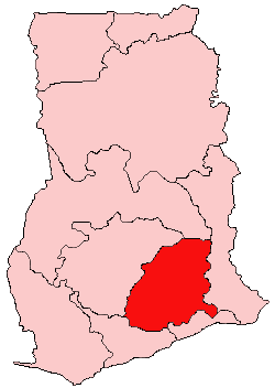
The Ashanti Region is located in the southern part of Ghana and is the third largest of 16 administrative regions, occupying a total land surface of 24,389 km2 (9,417 sq mi) and making up 10.2 percent of the total land area of Ghana. It is the most populated region in Ghana, with a population of 5,440,463 according to the 2021 census, accounting for around one-sixth of Ghana's total population. The Ashanti Region is known for its gold bar and cocoa production. The largest city and capital of Ashanti is Kumasi.

Obuasi is a gold mining town and is the capital of the Obuasi Municipal District in the Ashanti Region of Ghana. It lies in the southern part of the Obuasi Municipal and is located about 39 mi (63 km) from Kumasi. As of 2012, the town has a population of 175,043 people. The current mayor of the town is Hon. Elijah Adansi-Bonah.
Tepa is the capital of Ahafo Ano North, a municipality in the Ashanti Region of Ghana. The old town of Tepa is known as Kelebim. Kelebim can be found in Tepa Ward 1 and the new town is also known as Restco. The major occupation of the people there is farming and trading
Bekwai is a town and the capital of the Bekwai Municipal, a municipality in the Ashanti Region of Ghana. Bekwai is the seventy-ninth most populous settlement in Ghana, with a population of 7,267 people. Bekwai and Bekwai Municipal are south of the Ashanti regional capital of Kumasi, north of Obuasi.
Kwahu is an area and group of people that live in Ghana and are part of the Twi-speaking Akan group. The region has been dubbed Asaase Aban, or the Natural Fortress, given its position as the highest habitable elevation in the country. Kwahu lies in the Eastern Region of Ghana, on the west shore of Lake Volta. The Kwahus share the Eastern Region with the Akyem and Akuapem, as well as the Adangbe-Krobos. Among Kwahu lands, a significant migrant population works as traders, farm-hands, fisherfolk, and caretakers in the fertile waterfront 'melting pot' of Afram plains. These migrants are mostly from the Northern and Volta Regions, as well as, some indigenous Guans from the bordering Oti and Brong-Ahafo regions live in the Afram Plains area. Kwahus are traditionally known to be wealthy traders, owning a significant number of businesses and industries in Ghana.
Kumasi Metropolitan Assembly is one of the 261 Metropolitan, Municipal and District Assemblies (MMDAs) in Ghana. It forms part of the forty-three districts in Ashanti Region, Ghana with Kumasi being its administrative capital. The metropolis is located in the central part of Ashanti Region and has Kumasi as its capital city.With a projected population of over two million and an annual growth rate of about 5.4%, it is a rapidly expanding metropolis. The Metropolis is about 254 kilometers long, with a centrally located commercial area and a largely circular physical structure.The fast rate of urbanization is confirmed by estimates that 48%, 46%, and 60% of the Metropolis are rural, peri-urban, and urban, respectively.
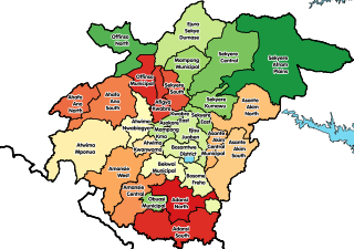
Offinso Municipal District is one of the forty-three districts in Ashanti Region, Ghana. Originally created as an ordinary district assembly in 1988 when it was known as Offinso District, which it was created from the former Offinso District Council; until the northern part of the district was later split off to create Offinso North District on 29 February 2008; while the remaining part was elevated to municipal district assembly status on the same year to become Offinso Municipal District. The municipality is located in the northern part of Ashanti Region and has Offinso as its capital town.
Asamankese is a town in south Ghana and is the capital of West Akim Municipal District, a district in the Eastern Region of south Ghana. Asamankese has a 2013 settlement population of approximately 39,435 people. Asamankese is on the main highway to Kumasi and Accra in the interior. The people of Asamankese celebrate the Obuodwan festival.
Agogo is a town in the Asante Akim North Municipal District of the Ashanti Region of Ghana. Agogo is approximately 80 kilometers (50 mi) east of Kumasi, the capital of the Ashanti Region, and had a population of 28,271 in the 2000 census. Computer projections estimate that the 2007 population was 32,859.
Mampong is a town and the capital of the Mampong Municipal in the Ashanti Region of Ghana. As of 2012, the town has a population of 42,037 people. The town is home to the Mamponghene, Nana Osei Bonsu II.
Fomena is a small town and the capital of the Adansi North District. The town is the seat of the paramount chief of the Adansi traditional council. The town is known as the place where the Fomena treaty was signed.
Agona-Akrofoso, sometimes called Akrofonso, is a town in the Sekyere South District in the Ashanti Region of Ghana, approximately 38 kilometres (24 mi) north-east of the Ashanti Regional capital, Kumasi, and about two miles east of Agona, the district capital.

The economy of the Ashanti Region in southern Ghana is largely self-sufficient, being driven by its service sector as well as by natural resources. The region is also known for its production of manganese, bauxite and agricultural commodities such as cocoa and yam, with the region having low levels of taxation and without much need for foreign direct investment. The Ashanti Region spans an area of 24,389 km2, and according to the 2000 census, the region had a population of 3,612,950, most of whom (94.2%) were ethnic Akans, of whom 82.9% were ethnic Ashanti. The capital of the region is Kumasi, which with a population of 2,069,350 as of 2013 represents a high level of urbanisation within the state.
Old Tafo Municipal District is one of the forty-three districts in Ashanti Region, Ghana. Originally it was a sub-metropolitan district council within the Kumasi Metropolitan Assembly until 15 March 2018, when it was elevated to municipal district assembly status to become Old Tafo Municipal District. The municipality is located in the central part of Ashanti Region and has Tafo as its capital town.
Twedie is a town in the Ashanti Region of Ghana. It's located 16 km west of Kumasi, the Ashanti Regional capital. Twedie is the district capital of the Atwima Kwanwoma District.


