Afadzato South District

Last updated

Afadzato South District
Districts of the Volta Region (2018).png
Districts of Volta Region
Ghana adm location map.svg
Red pog.svg
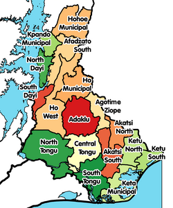
Afadzato South District
Location of Afadzato South District within Volta
Coordinates: 6°59′32.12″N0°25′32.12″E / 6.9922556°N 0.4255889°E / 6.9922556; 0.4255889
CountryFlag of Ghana.svg  Ghana
Region Flag of Volta Region.png Volta
Capital Ve Golokwati
Government
  District ExecutiveHon. James Etornam Flolu [1]
Population
 (2021)
  Total73,146
Time zone UTC+0 (GMT)
ISO 3166 code GH-TV-AF
Website http://afadzatosouthdistrictgh.com/6/download-documents-from-afadjato-south-district-assembly

Afadzato South District (a.k.a. Afadzato Anyigbe) is one of the eighteen districts in Volta Region, Ghana. [2] Originally it was formerly part of the then-larger Hohoe District on 10 March 1989, until the southern part of the district was split off to create Afadzato South District on 28 June 2012; thus the remaining portion has been retained as Hohoe Municipal District . The district assembly is located in the northern part of Volta Region and has Ve Golokwati as its capital town.

Contents

Geography

The District shares boundaries with Hohoe Municipal to the North, Kpando Municipal to the west, to the east with the Republic of Togo and to the south with Ho West District and South Dayi District respectively.

Villages

  • Have
  • Ve-Golokuati
  • Ve-Kolenu
  • Ve-Gbodome
  • Ve-Hoeme
  • Ve Deme
  • Ve-Agbome
  • Ve-Dafor
  • Ve-Wudome
  • Nyagbo-Agordome
  • Nyagbo-Akofafanami
  • Nyagbo-Anyigbe
  • Nyagbo-Emli Israel
  • Nyagbo-Fiafe
  • Nyagbo-Gagbefe
  • Nyagbo-Konda
  • Nyagbo-Kume
  • Nyagbo-Odumase
  • Nyagbo-Sroe
  • Leklebi-Agbesia
  • Leklebi-Asortodzi
  • Leklebi-Blemiado
  • Leklebi-Dafor
  • Leklebi-Duga
  • Leklebi-Fiafe
  • Leklebi-Heheme
  • Leklebi Kame
  • Leklebi-Liata
  • Leklebi-Wobe
  • Liati-Agbatiave
  • Liati-Agboglidome
  • Liati-Agbonyra
  • Liati-Avetome
  • Liati-Dafornu
  • Liati-Dalekpedzi
  • Liati-Datem
  • Liati-Odumasi
  • Liati-Peterkofe
  • Liati-Sawali
  • Liati Soba
  • Liati-Tadzi
  • Liati-Teikrom
  • Liati-Torganu
  • Liati-Wote
  • Logba-Adiveme
  • Logba-Adzakoe
  • Logba-Akusame
  • Logba-Alakpeti
  • Logba-Andokope
  • Logba-Dufie
  • Logba-Klikpo
  • Logba-Tota
  • Logba-Vuinta
  • Logba-Xorglikope
  • Tafi-Abuipe
  • Tafi-Agorme
  • Tafi-Atome
  • Tafi-Dekpokorfe
  • Tafi-Mador
  • Tafi-Xorglikorfe
  • Kpeve-Old Town
  • Kpeve-Tornu
  • Adigbo-Tornu
  • Goviefe-Todzi
  • Goviefe-Korwu
  • Goviefe-Agordome
  • Woadze
  • Woadze-Tornu
  • Woadze-Kokomba Korfe
  • Woadze Tsatoe
  • Agate

Population and Distribution

The total population of the District according to the 2010 Population and Housing Census is about 95,030 with the male population numbering approximately 46,272, representing 48.7 percent and the female population numbering 48,758 constituting the remaining 51.3 percent. The population of the District forms 4.5 percent of the Regional population. The District has majority of its people in the rural areas (81.3%) compared to (18.7%) in the urban areas. [3]

Sources

Related Research Articles

<span class="mw-page-title-main">Ho, Ghana</span> City in Volta Region, Ghana

Ho is the capital city of the Ho Municipal District and the Volta Region of Ghana. The city lies between Mount Adaklu and Mount Galenukui or Togo Atakora Range, and is home to the Volta Regional Museum, a cathedral, and a prison. It was formerly the administrative capital of British Togoland now part of the Volta Region. The population of Ho Municipality according to the 2010 Population and Housing Census is 177,281 representing 8.4 percent of the region's total population. Females constitute 52.7 percent and males represent 47.3 percent. About 62 percent of the population resides in urban localities. The Municipality shares boundaries with Adaklu and Agotime-Ziope Districts to the South, Ho West District to the North and West and the Republic of Togo to the East. Its total land area is 2,361 square kilometers thus representing 11.5 percent of the region's total land area.

<span class="mw-page-title-main">Districts of Ghana</span> Second-level administrative subdivisions of Ghana

The Districts of Ghana are second-level administrative subdivisions of Ghana, below the level of region. There are currently 261 local metropolitan, municipal and district assemblies.

<span class="mw-page-title-main">Volta Region</span> Region of Ghana

Volta Region is one of Ghana's sixteen administrative regions, with Ho designated as its capital. It is located west of Republic of Togo and to the east of Lake Volta. Divided into 25 administrative districts, the region is multi-ethnic and multilingual, including groups such as the Ewe, the Guan, and the Akan peoples. The Guan peoples include the Lolobi, Likpe, Akpafu, Buem, and Nkonya people. This region was carved out of the Volta Region in December 2018 by the New Patriotic Party. The people of the Volta Region are popularly known as Ewes. The people of the Volta Region are popular known for their rich cultural display and music some of which include Agbadza, Borborbor and Zigi.

<span class="mw-page-title-main">Hohoe</span> Town in Volta Region, Ghana

Hohoe Municipal is one of the 25 administrative districts of the Volta Region of Ghana. It was carved out of the former Kpando District. It was established by the Legislative Instrument of 2012. The Municipality has a total land area of 1,172 km2, which is 5.6 per cent of the land area of the region. It shares borders with the Republic of Togo on the east, forming part of Ghana's international border; on the southeast by the Afadzato district and southwest by Kpando Municipality; on the north with Jasikan district; and on the northwest with the Biakoye districts. Its capital, Hohoe, is about 78 km from Ho, the regional capital and 220 km from Accra, the national capital. The population of Hohoe Municipality, according to the 2010 Population and Housing Census, is 167,016 representing 7.9 per cent of the total population of the Volta Region. It comprises 52.1 per cent females and 47.9 percent males.

Kpando is a town and capital of Kpando Municipal District in the northern Volta Region of Ghana. It is near the north eastern arm of Lake Volta and the Togo border. Kpando is the fifty-fourth most populous place in Ghana, in terms of population, with a population of 28,334 people. Kpando is connected by ferry and road to Gbefi, Hohoe, Ho and Dambai. It is about a 4-hour journey from Accra. The Kpando Municipality is a district in the Volta Region, and one of the oldest administrative districts in Ghana.

<span class="mw-page-title-main">Jasikan District</span> District in Ghana

Jasikan District is one of the eight districts in Oti Region, Ghana. Originally created as an ordinary district assembly on 10 March 1989, which was created from the former Jasikan District Council, which it was established by Legislative Instrument (L.I.) 1464, until the western part of the district was split off to create Biakoye District on 29 February 2008, which was established by Legislative Instrument (L.I.) 1901; thus the remaining part has been retained as Jasikan District. The district assembly is located in the southern part of Oti Region and has Jasikan as its capital town.

<span class="mw-page-title-main">Kpando Municipal District</span> Municipal District in Volta Region, Ghana

Kpando Municipal District is one of the eighteen districts in Volta Region, Ghana. Originally created as an ordinary district assembly on 10 March 1989 when it was known as Kpando District, until the southern part of the district was split off by a decree of president John Agyekum Kufuor on 19 August 2004 to create South Dayi District; thus the remaining part has been retained as Kpando District. However on 28 June 2012, the southern part of the district was later split off to create North Dayi District on 28 June 2012; while the remaining part was elevated to municipal district assembly status on the same year to become Kpando Municipal District. The municipality is located in the western part of Volta Region and has Kpando as its capital town.

<span class="mw-page-title-main">Yilo Krobo Municipal District</span> Municipal District in Ghana

Yilo Krobo Municipal District is one of the thirty-three districts in Eastern Region, Ghana. Originally created as an ordinary district assembly in 1988 when it was known as Yilo Krobo District, which it was created from the former Kaoga District Council, until it was elevated to municipal district assembly status on 6 February 2012 to become Yilo Krobo Municipal District. The municipality is located in the eastern part of Eastern Region and has Somanya as its capital town.

Somanya is a town and the capital of Yilo Krobo District, a district in the Eastern Region of south Ghana. Somanya has a 2013 settlement population of 20,596 people.And currently has a settlement population of 16,441,362 in the year 2021. Because the town is surrounded by a number of farming communities to the north of it, the name Somanya is used to encompass a collection of smaller communities around a bigger one. As a result, the 2010 Population and Housing Census conducted by the Government of Ghana put the population of Somanya at 87,847, representing 3.3% of the region's total population. Males constitute 48.2 percent of the population while females represent 51.8 percent, according to the Ghana Census Bureau. The entire Krobo district is described as rural, and Somanya is the municipal district center of the surrounding smaller towns. With the capital of Ghana, Accra, rapidly expanding northwards, the traveling distance between Somanya and Accra is shrinking and now is around 30 miles (48 km). The temperatures are highest on average in March, at around 28.4 °C. At 25.1 °C on average, August is the coldest month of the year.

<span class="mw-page-title-main">South Dayi District</span> District in Ghana

South Dayi District is one of the eighteen districts in Volta Region, Ghana. Originally it was formerly part of the then-larger Kpando District on 10 March 1989, until the southern part of the district was split off by a decree of president John Agyekum Kufuor on 19 August 2004 to create South Dayi District; thus the remaining part has been retained as Kpando District. The district assembly is located in the western part of Volta Region and has Kpeve as its capital town.

<span class="mw-page-title-main">Bawku Municipal District</span> Municipal district in Upper East region, Ghana

Bawku Municipal District is one of the fifteen districts in Upper East Region, Ghana. Originally created as an ordinary district assembly in 1988 when it was known as Bawku East District; which was established by Legislative Instrument (L.I.) 1439, until the southern part of the district was split off by a decree of president John Agyekum Kufuor in August 2004 to create Garu-Tempane District; thus the remaining part was elevated to municipal district assembly status on the same year to become Bawku Municipal District. However, on 28 June 2012, two parts of the district were later split off to create Binduri District and Pusiga District respectively; thus the remaining part has been retained as Bawku Municipal District. The municipality is located in the eastern part of Upper East Region and has Bawku as its capital town.

<span class="mw-page-title-main">Hohoe (Ghana parliament constituency)</span> Constituency in Ghana

Hohoe is one of the constituencies represented in the Parliament of Ghana. It elects one Member of Parliament (MP) by the first past the post system of election. Hohoe is located in the Hohoe Municipal district of the Volta Region of Ghana.

<span class="mw-page-title-main">Biakoye</span>

The Biakoye constituency is one of the constituencies represented in the Parliament of Ghana. It elects one Member of Parliament (MP) by the first past the post system of election. It is located in the Biakoye district of the Oti Region of Ghana.

Joseph Zaphenat Amenowode is a Ghanaian politician and academic. He was the Member of Parliament for Hohoe South and was the Minister for the Volta Region of Ghana from January 2009 until his dismissal on 6 March 2012. He has worked as a university lecturer prior to going into politics.

<span class="mw-page-title-main">Kpandai District</span> District in Northern Region, Ghana

Kpandai District is one of the sixteen districts in Northern Region, Ghana. Originally it was formerly part of the then-larger East Gonja District in 1988, until the eastern part of the district was split off by a decree of president John Agyekum Kufuor on 29 February 2008 to create Kpandai District.; thus the remaining part has been retained as East Gonja Municipal District. The district assembly is located in the southern part of Northern Region and has Kpandai as its capital town.

<span class="mw-page-title-main">Ga West Municipal District</span> Municipal District in Ghana

Ga West Municipal District is one of the twenty-nine districts in Greater Accra Region, Ghana. Originally it was formerly part of the then-larger Ga District in 1988, until the eastern part of the district was split off to create Ga East District in 2004; thus the remaining part has been renamed as Ga West District. Later, the western part of the district was split off to create the first Ga South Municipal District on 29 February 2008, with Weija as its capital town; while Ga West was later elevated to municipal district assembly status during that same year to become Ga West Municipal District. However on 15 March 2018, the eastern part of the district has split off to create Ga North Municipal District, thus the remaining part has been retained as Ga West Municipal District. The municipality is located in the western part of Greater Accra Region and has Amasaman as its capital town.

Kpassa is the capital of Nkwanta North District, a district in the Oti Region of Ghana. The Oti Region was part of the Volta Region of Ghana until 2019. The inhabitants of Kpassa are mostly Konkomba people. The other inhabitants are Basare. The Bassares and famous for their fire dance.There are also Akan, Ewe, Anufo, Krachi and Gonja people. In the past, the inhabitants of Kpassa have mainly engaged in farming. This trend has changed during the past two decades. Younger inhabitants are actively pursuing education and small-scale business activities, while the older ones are into governance. As a result, Kpassa has undergone rapid expansion during these past two decades. The town is expected to expand further once the Eastern Corridor Road Project is completed. In terms of architecture, a returning visitor will easily noticed that the town is rapidly shifting from mud buildings or atakpame to modern block buildings. In fact, most people in the town attach this shift to prestige and affluence in the society. At the current rate, one is expected to find fewer atakpame buildings a decade in the future. The economy of Kpassa is critical to the Volta Region, owing to its engagement in the production of valuable agricultural products such as corn, yam, cassava, millet, groundnuts, pepper, soya beans, and beans, among others.

<span class="mw-page-title-main">Hohoe Municipal District</span> Municipal District in Ghana

Hohoe Municipal District is one of the eighteen districts in Volta Region, Ghana. Originally created as an ordinary district assembly in 1988 when it was known as Hohoe District, until it was elevated to municipal district assembly status on 29 February 2008 to become Hohoe Municipal District. However on 28 June 2012, the southern part of the district was split off to create Afadzato South District; thus the remaining part has been retained as Hohoe Municipal District. The municipality is located in the northern part of Volta Region and has Hohoe as its capital town.

Ve Golokwati is a small town and is the capital of Afadzato South district, a district in central Volta Region of Ghana.

<span class="mw-page-title-main">Ho West District</span> District in Volta Region, Ghana

Ho West District is one of the eighteen districts in Volta Region, Ghana. Originally it was formerly part of the then-larger Ho District on 10 March 1989, until the western part was split off to create Ho West District on 28 June 2012; thus the remaining part was elevated to municipal district assembly status on that same year to become Ho Municipal District. The district assembly is located in the central part of Volta Region and has Dzolokpuita as its capital town.

References

  1. "29 year entrepreneur confirm as new DCE for Afadzato South". Archived from the original on 13 February 2020. Retrieved 13 February 2020.
  2. "Volta » Afadzato South (New)". GhanaDistricts.com. Ministry of Local Government and Rural Development and Maks Publications & Media Services. Archived from the original on 12 July 2015. Retrieved 25 July 2015.
  3. Afadzato South Distric. "2010 Population & Housing Census, District Analytical Report" (PDF). Archived (PDF) from the original on 29 October 2020.

6°59′32.12″N0°25′32.12″E / 6.9922556°N 0.4255889°E / 6.9922556; 0.4255889