 |
|---|
Namibia is divided into 14 regions subdivided, which are further subdivided into 121 constituencies. The administrative divisions of Namibia are tabled by Delimitation Commissions and accepted or declined by the National Assembly.
| |
|---|
Namibia is divided into 14 regions subdivided, which are further subdivided into 121 constituencies. The administrative divisions of Namibia are tabled by Delimitation Commissions and accepted or declined by the National Assembly.
Before the independence of Namibia, the territory was known as South-West Africa (before 1885 and between 1915 and 1989) and as German South-West Africa during the time of colonialisation by the German Empire (1885-1915).
During the South African administration it was considered the de facto fifth province of South Africa, although a formal request for annexation to the United Nations was turned down. [1] The territory that became the independent state of Namibia on 21 March 1990 inherited the administrative division of this "province" which consisted of 26 districts. These districts remained until the First Delimitation Commission of Namibia tabled its recommendations in the National Assembly, and the latter approved and implemented them in 1992. Since then, Namibia is divided into regions which in turn are divided into constituencies. [2]
Delimitation Commissions are three-member bodies appointed by the president that make suggestions as to how Namibia should be administratively divided, considering only geographical changes like population grow and migration but not discriminating by ethnic factors. They are mentioned in articles 102-104 of the constitution, and they are to sit approximately once every ten years, [3] although they sat more frequently before 2002.
The chairman of the Delimitation Commission must be a judge at either a High Court or the Supreme Court. This judge and the other two commission members are appointed by the president, subject to the approval of Parliament. [3]
The five Delimitation Commissions of Namibia so far are: [2]
| Commission | Formed | Members | Decisions |
|---|---|---|---|
| 1st | 1990 | Judge President Johan Strydom Martin Shipanga Gerhard Tötemeyer |
|
| 2nd | 1998 | Judge JP Karuaihe Samuel Mbambo Lazarus Hangula |
|
| 3rd | 2002 | Judge Peter Shivute Inge Murangi Peter Kauluma |
|
| 4th | 2013 | Judge Alfred Siboleka Zedekia Ngavirue Jonathan Steytler | |
| 5th | 2024 | Judge President Petrus Unengu Prisca Anyolo Gerhardt Gurirab Penias Topnaar [6] |
|

The current administrative division of Namibia is the result of the work of the Fourth Delimitation Commission, tabled in 2013. Namibia is divided into 14 regions and 121 constituencies. [5]

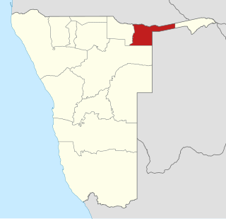
The Zambezi Region is one of Namibia's fourteen regions, situated in the north-eastern part of the country along the Zambezi River where it gets its name from. The region's capital is the town of Katima Mulilo. The Katima Mulilo Airport is 18 kilometres south-west of the town, while the village of Bukalo is located 43 kilometres south-east of Katima Mulilo. Formerly known as the Caprivi Region until 2013, it has eight electoral constituencies and a population of 142,373 according to the 2023 census.

Portugal is a unitary state with delegated authority to three levels of local government that cover the entire country:

Kavango was one of the thirteen regions of Namibia until it was split into the Kavango East and Kavango West Regions in 2013. Its capital was Rundu.

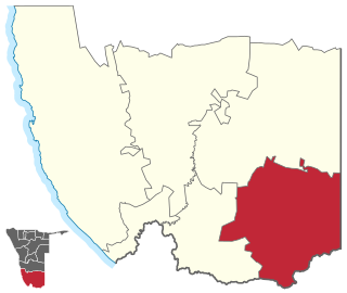
The ǁKharas Region is the southernmost, largest, and least densely populated of the 14 regions of Namibia; its capital is Keetmanshoop. The name assigned to the region reflects the prominence of the Karas mountain range in its southern part. The ǁKharas region contains the municipality of Keetmanshoop, the towns Karasburg, Lüderitz and Oranjemund, and the self-governed villages Aroab, Berseba, Bethanie, Koës and Tses.

Khomas is one of the fourteen regions of Namibia. Its name refers to the Khomas Highland, a high plateau landscape that dominates this administrative subdivision. Khomas is centered on the capital city Windhoek and provides for this reason superior transportation infrastructure. It is located in the central highlands of the country and is bordered by the Erongo region to the west and the northwest and by the Otjozondjupa region to the north. To the east is the Omaheke region, while in the south is the Hardap region. The region is characterized by its hilly countrysize and many valleys. It has well-developed economical, financial, and trade sectors. Khomas Region occupies 4.5% of the land area of Namibia but has the highest population of any of its regions (16.2%). Khomas is one of only three Namibian regions to have neither shoreline nor a foreign border.

Namibia uses regions as its first-level subnational administrative divisions. Since 2013, it has 14 regions which in turn are subdivided into 121 constituencies.

ǃNamiǂNûs is an electoral constituency in the ǁKaras Region of Namibia. It contains the major town of Lüderitz, after which the constituency was originally named. In 2011, it had a population of 13,859, down from 14,542 in 2001. As of 2020 the constituency had 9,670 registered voters.

Mpungu is a constituency in the Kavango West region of Namibia. It had a population of 20,787 in 2011, up from 18,660 in 2001, and 9,121 registered voters in 2020, up from 8,924 in 2004.
Kapako is a constituency in the Kavango West region of Namibia. The district centre is the settlement of Kapako. It had a population of 26,983 in 2011, up from 26,263 in 2001.

Ndiyona is a constituency in the Kavango East region of Namibia. The district centre is the settlement of Ndiyona. It had a population of 20,633 in 2011, up from 19,565 in 2001. As of 2020 the constituency had 6,210 registered voters.

Aranos is a town in the Hardap Region of central Namibia, situated in the Nossob River basin in the Kalahari Desert.
Kavango East is one of the fourteen regions of Namibia. Its capital is Rundu, its governor is Bonifatius Wakudumo. The region was created in 2013 when the Kavango Region was split into Kavango East and Kavango West. The only self-governing settlements in Kavango East are the capital Rundu and the village of Divundu.

Kavango West is one of the fourteen regions of Namibia. Its capital and only self-governed settlement is Nkurenkuru, its governor is Sirkka Ausiku. The Region was created in 2013 when the Kavango Region was split into Kavango East and Kavango West. In the north, Kavango West borders the Cuando Cubango Province of Angola. Domestically, it borders the regions of Kavango East to the east, Otjozondjupa to the south, Oshikoto to the west and Ohangwena to the northwest.

Opuwo Rural is an electoral constituency in the Kunene Region of Namibia. The administrative centre of Opuwo Rural is the settlement of Otuani. As of 2020, it has 7,315 registered voters.

Oshikunde Constituency is an electoral constituency in the Ohangwena Region of Namibia. As of 2020, it has 8,062 registered voters.

Ndonga Linena Constituency is an electoral constituency in the Kavango East Region of Namibia. It was created in August 2013, following a recommendation of the Fourth Delimitation Commission of Namibia, and in preparation of the 2014 general election. The administrative centre of Ndonga Linena Constituency is the settlement of Ndonga Linena. Ndonga Linena was formed from the western part of the Ndiyona Constituency. As of 2020 the constituency had 6,597 registered voters.
Mankumpi Constituency is an electoral constituency in the Kavango West Region of Namibia. The administrative centre is the village of Satotwa. Mankumpi was created in August 2013, following a recommendation of the Fourth Delimitation Commission of Namibia, and in preparation of the 2014 general election. It was formed from the south-eastern part of the former Kahenge Constituency.
Nkurenkuru Constituency is an electoral constituency in the Kavango West Region of Namibia. It was created in August 2013, following a recommendation of the Fourth Delimitation Commission of Namibia, and in preparation of the 2014 general election. The administrative centre of Nkurenkuru Constituency is the town of Nkurenkuru. Before the administrative change in 2013 the area of this constituency, including the town of Nkurenkuru, was part of Mpungu Constituency in the Kavango Region.
Karasburg East is an electoral constituency in the ǁKaras Region of Namibia. As of 2020 the constituency had 6,553 registered voters.