Kavango West

Last updated
Kavango West
Region
Kavango West in Namibia.svg
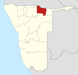
The Kavango West Region (dark grey) in Namibia
Country Namibia
Seat Nkurenkuru
Government
  Governor Sirkka Ausiku [1] (SWAPO)
Area
  Total24,591 km2 (9,495 sq mi)
Population
 (2023 census) [2]
  Total123,266
  Density5.0/km2 (13/sq mi)
Time zone UTC+2 (CAT)
Website kavangowestrc.gov.na

Kavango West is one of the fourteen regions of Namibia. Its capital and only self-governed settlement is Nkurenkuru, its governor is Sirkka Ausiku. The Region was created in 2013 when the Kavango Region was split into Kavango East and Kavango West. In the north, Kavango West borders the Cuando Cubango Province of Angola. Domestically, it borders the following regions:

Contents

Because of its rather high rainfall compared to most other parts of Namibia and its location on the Kavango River after which it was named, this region has agricultural potential for the cultivation of a variety of crops, as well as for organised forestry and agro-forestry, which stimulates furniture making and related industries. Kavango West and its sister region Kavango East are nevertheless the poorest regions in Namibia. [3]

Politics

The Fourth Delimitation Commission of Namibia, responsible for recommending on the country's administrative divisions suggested in August 2013 to split the Kavango Region into two. The president Hifikepunye Pohamba enacted the recommendations. As a result, the new Regions of Kavango East and Kavango West have been created. [4] As of 2020, Kavango West had 23,804 registered voters. [5]

Administrative division

The region is subdivided into eight electoral constituencies: [6] [4]

In the 2015 regional elections SWAPO won in all eight constituencies. [7] SWAPO also won all constituencies in the 2020 regional election, all of them by a landslide, and with overall more than 90% of the votes. [5]

Governors

The first Governor of Kavango West was Samuel Mbambo, former Governor of the Kavango Region and sitting Governor of Kavango East. [6] On 27 April 2014 Sirkka Ausiku, formerly Permanent Secretary of the Ministry of Regional and Local Government, Housing and Rural Development, was appointed. [8] He kept his position in 2015 in president Hage Geingob 's new government. [1]

Health services

Kavango East and West Regional Health Directorate has the following facilities. Hospitals = 1. Health Centers = 2. Primary Health Care Clinics = 26. [9]

Population

The region is characterised by an extremely uneven population distribution. The interior is very sparsely inhabited, while the northernmost strip, especially along the Kavango River, has a high population concentration.

Data and statistics

Related Research Articles

<span class="mw-page-title-main">Kavango Region</span> Former Region in Namibia

Kavango was one of the thirteen regions of Namibia until it was split into the Kavango East and Kavango West Regions in 2013. Its capital was Rundu.

<span class="mw-page-title-main">Hardap Region</span> Region in Namibia

Hardap is one of the fourteen regions of Namibia, its capital is Mariental. Hardap contains the municipality of Mariental, the towns Rehoboth and Aranos, and the self-governed villages Gibeon, Gochas, Kalkrand, Stampriet and Maltahöhe. It is home to the Hardap Dam.

<span class="mw-page-title-main">ǁKaras Region</span> Region in Namibia

The ǁKaras Region is the southernmost, largest, and least densely populated of the 14 regions of Namibia; its capital is Keetmanshoop. The name assigned to the region reflects the prominence of the Karas mountain range in its southern part. The ǁKaras region contains the municipality of Keetmanshoop, the towns Karasburg, Lüderitz and Oranjemund, and the self-governed villages Aroab, Berseba, Bethanie, Koës and Tses.

<span class="mw-page-title-main">Otjozondjupa Region</span> Region in Namibia

Otjozondjupa is one of the fourteen regions of Namibia. Its capital is Otjiwarongo. The region further contains the municipalities of Okahandja and Grootfontein and the towns Okakarara and Otavi. As of 2020, Otjozondjupa had 97,945 registered voters.

<span class="mw-page-title-main">Oshikoto Region</span> Region in Namibia

Oshikoto is one of the fourteen regions of Namibia, named after Lake Otjikoto. Its capital is Omuthiya. Further major settlements in the region are Tsumeb, Otjikoto's capital until 2008, and Oniipa. As of 2020, Oshikoto had 112,170 registered voters.

<span class="mw-page-title-main">Omaheke Region</span> Region in Namibia

Omaheke is one of the fourteen regions of Namibia, the least populous region. Its capital is Gobabis. It lies in eastern Namibia on the border with Botswana and is the western extension of the Kalahari desert. The self-governed villages of Otjinene, Leonardville and Witvlei are situated in the region. As of 2020, Omaheke had 48,594 registered voters.

<span class="mw-page-title-main">Ohangwena Region</span> Region in Namibia

Ohangwena is one of the fourteen regions of Namibia, its capital is Eenhana. Major settlements in the region are the towns Eenhana and Helao Nafidi as well as the self-governed village of Okongo and the proclaimed settlements Ongenga and Omungwelume. As of 2020, Ohangwena had 150,724 registered voters.

Nkurenkuru is a town on the south-western banks of the Kavango River. It is the capital of the Kavango West Region of northern Namibia, located 140 kilometres (87 mi) west of Rundu. It is also a former mission station of the Finnish Missionary Society.

<span class="mw-page-title-main">Mpungu Constituency</span> Electoral constituency in the Kavango West region of northern Namibia

Mpungu is a constituency in the Kavango West region of Namibia. It had a population of 20,787 in 2011, up from 18,660 in 2001, and 9,121 registered voters in 2020, up from 8,924 in 2004.

<span class="mw-page-title-main">Kapako Constituency</span> Electoral constituency in the Kavango West region of northern Namibia

Kapako is a constituency in the Kavango West region of Namibia. The district centre is the settlement of Kapako. It had a population of 26,983 in 2011, up from 26,263 in 2001.

<span class="mw-page-title-main">Ndiyona Constituency</span> Electoral constituency in the Kavango East region of north-eastern Namibia

Ndiyona is a constituency in the Kavango East region of Namibia. The district centre is the settlement of Ndiyona. It had a population of 20,633 in 2011, up from 19,565 in 2001. As of 2020 the constituency had 6,210 registered voters.

<span class="mw-page-title-main">Rundu Urban</span> Electoral constituency in the Kavango East region of north-eastern Namibia

Rundu Urban is an electoral constituency in the Kavango East region of Namibia. It covers the urban area of Rundu, the region's capital and one of Namibia's largest cities. The constituency also covers parts of the Sauyemwa, Safari, Tutungeni, Katutura, Donkerhoek and Kehemu neighborhoods. It had a population of 20,953 in 2011, up from 19,173 in 2001. As of 2020 the constituency had 35,740 registered voters.

<span class="mw-page-title-main">Kavango East</span> Region in Namibia

Kavango East is one of the fourteen regions of Namibia. Its capital is Rundu, its governor is Bonifatius Wakudumo. The region was created in 2013 when the Kavango Region was split into Kavango East and Kavango West. The only self-governing settlements in Kavango East are the capital Rundu and the village of Divundu.

<span class="mw-page-title-main">Rundu Rural</span> Electoral constituency in the Kavango East region of north-eastern Namibia

Rundu Rural is an electoral constituency in the Kavango East Region of Namibia. It comprises the area east of Rundu, one of Namibia's largest cities. It had a population of 22,538 in 2011, up from 18,250 in 2001. As of 2020 the constituency had 6,060 registered voters.

<span class="mw-page-title-main">Nkurenkuru Constituency</span> Electoral constituency in the Kavango West region of northern Namibia

Nkurenkuru Constituency is an electoral constituency in the Kavango West Region of Namibia. It was created in August 2013, following a recommendation of the Fourth Delimitation Commission of Namibia, and in preparation of the 2014 general election. The administrative centre of Nkurenkuru Constituency is the town of Nkurenkuru. Before the administrative change in 2013 the area of this constituency, including the town of Nkurenkuru, was part of Mpungu Constituency in the Kavango Region.

<span class="mw-page-title-main">Tondoro Constituency</span> Electoral constituency in the Kavango West region of northern Namibia

Tondoro Constituency is an electoral constituency in the Kavango West Region of Namibia. Tondoro Constituency was named after the village and mission station Tondoro, although the administrative centre is in the village of Mburuuru.

<span class="mw-page-title-main">Musese Constituency</span> Electoral constituency in the Kavango West region of northern Namibia

Musese is a constituency in the Kavango West region of Namibia. The administrative capital is the settlement of Rupara. As of 2020 the constituency had 6,494 registered voters.

<span class="mw-page-title-main">Ncuncuni Constituency</span> Electoral constituency in the Kavango West region of northern Namibia

Ncuncuni is a constituency in the Kavango West region of Namibia. It is located west of Rundu, one of Namibia's largest cities. It had a population of 38,281 in 2011, up from 26,623 in 2001. As of 2020 the constituency had 4,554 registered voters.

<span class="mw-page-title-main">Ondangwa Rural</span> Electoral constituency in the Oshana region of northern Namibia

Ondangwa Rural is an electoral constituency in the Oshana Region of Namibia. It had 13,613 inhabitants in 2016 and 7,682 registered voters in 2020. The administrative centre of the constituency is the settlement Eheke.

Sirkka Namutenya Anneli Mwahafa Ausiku is a Namibian administrator and politician. She is the governor of Kavango West Region since 2014.

References

  1. 1 2 "President announces governors". The Namibian . 10 April 2015. Archived from the original on 14 April 2015. Retrieved 14 April 2015.
  2. "2023 Population & Housing Census Preliminary Report" (PDF). Statistics Namibia.
  3. Kandjimi, Shoki (5 November 2020). "Kavango East not a poor region - governor". New Era . p. 1.
  4. 1 2 Nakale, Albertina (9 August 2013). "President divides Kavango into two". New Era . allafrica.com. Archived from the original on 22 October 2014. Retrieved 16 August 2013.
  5. 1 2 "Regional Council 2020 Election Results". Interactive map. Electoral Commission of Namibia. 18 January 2021. Archived from the original on 12 June 2021. Retrieved 11 May 2021.
  6. 1 2 Haufiku, Mathias (22 August 2013). "Kavango awaits second governor". New Era . Archived from the original on 31 August 2013. Retrieved 27 August 2013.
  7. "Regional Council Election Results 2015". Electoral Commission of Namibia. 3 December 2015. pp. 7–8. Archived from the original on 8 December 2015.
  8. "New broom in new region". The Namibian . Vol. 28, no. 76. NAMPA. 28 April 2014. p. 2.
  9. "kavango west - Google Search". www.google.com. Retrieved 2023-09-09.
  10. "Kavango West - Namibia | Data and Statistics - knoema.com". Knoema. Retrieved 2023-09-09.

18°15′S18°55′E / 18.250°S 18.917°E / -18.250; 18.917