Erongo Region

Last updated
Erongo Region
Erongo in Namibia.svg
Location of the Erongo Region in Namibia
Coordinates: 22°00′S15°35′E / 22.00°S 15.59°E / -22.00; 15.59
Country Namibia
Capital Swakopmund
Government
  Governor Neville Andre Itope [1]
Area
[2]
  Total63,539 km2 (24,533 sq mi)
Population
 (2023 census) [3] [4]
  Total240,206
  Density3.8/km2 (9.8/sq mi)
Time zone UTC+2 (CAT)
HDI (2017)0.711 [5]
high · 2nd
Website www.erc.com.na

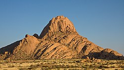
Erongo is one of the 14 regions of Namibia. The capital is Swakopmund. It is named after Mount Erongo, a well-known landmark in Namibia and in this area. Erongo contains the municipalities of Walvis Bay, Swakopmund, Henties Bay and Omaruru, as well as the towns Arandis, Karibib and Usakos. All the main centres within this region are connected by paved roads.

Contents

The Erongo Region had a population of 150,809 in 2011. [3] As of 2020, it had 119,784 registered voters. [6]

In the west, Erongo has a shoreline on the Atlantic Ocean. On land, it borders the following regions:

Economy and infrastructure

Various mining operations occur within this region at places such as Navachab and on a smaller scale at places surrounding Uis and the desert area. Karibib also has a marble industry. Walvis Bay, fully incorporated into the Erongo Region in 1994, is the principal home of Namibia's fishing industry. Walvis Bay also boasts the only deep sea port and is the second largest town in the country. Swakopmund and Langstrand are popular beach resorts; Arandis supports mining industry and Swakopmund boasts manufacturing.

This region, with its link to the coast of Namibia, is well developed. Facilities such as schools, hospitals and clinics, the supply of electricity and telecommunication services are, with a few exceptions, well established. Erongo has 66 schools with a total of 32,114 pupils. [7]

Politics

The region comprises seven electoral constituencies:

In the 2015 regional elections, SWAPO obtained 65% of the total votes (2010: 67%) [6] and won six of the seven constituencies with only Dâures, traditionally a United Democratic Front (UDF) stronghold, narrowly won by the opposition. [8] [9] In the 2020 regional election the Independent Patriots for Change (IPC), an opposition party formed in August 2020, was the strongest party. It obtained 36.8% of votes overall and won three constituencies, including Swakopmund and Walvis Bay Urban. SWAPO obtained 30.5% of all votes and also won three constituencies. Dâures was again narrowly won by the UDF. [6]

The governors of Erongo are:

Demographics

According to the Namibia 2001 Population and Housing Census, Erongo had a population of 107,663 (50,040 females and 57,616 males or 115 males for every 100 females) growing at an annual rate of 1.3%. The fertility rate was 3.2 children per woman. 80% inhabitants lived in urban areas while 20% lived in rural areas, and with an area of 63,579 km2, the population density was 1.7 persons per km2. By age, 11% of the population was under 5 years old, 18% between 5–14 years, 64% between 15–59 years, and 6% were 60 years and older. The population was divided into 27,496 households, with an average size of 3.8 persons. 35% of households had a female head of house, while 65% had a male. For those 15 years and older, 57% had never married, 24% married with certificate, 2% married traditionally, 10% married consensually, 2% were divorced or separated, and 3% were widowed. [11]

The most commonly spoken languages at home were Oshiwambo (37% of households), Afrikaans (22%), and Damara/Nama (21%) and German. [12] For those 15 years and older, the literacy rate was 92%. In terms of education, 89% of girls and 86% of boys between the ages of 6–15 were attending school, and of those older than 15, 79% had left school, 9% were currently at school, and 8% had never attended. [11]

In 2001 the employment rate for the labor force (71% of those 15+) was 66% employed and 34% unemployed. For those 15+ years old and not in the labor force (24%), 35% were students, 34% homemakers, and 31% retired, too old, etc. [11] According to the 2012 Namibia Labour Force Survey, unemployment in the Erongo Region stood at 25.5%. The two studies are methodologically not comparable. [13]

Among households, 96% had safe water, 12% no toilet facility, 73% electricity for lighting, 89% access to radio, and 20% had wood or charcoal for cooking. In terms of household's main sources of income, 4% derived it from farming, 67% from wages and salaries, 8% cash remittances, 8% from business or non-farming, and 10% from pension. [11]

For every 1000 live births there were 43 female infant deaths and 54 male. The life expectancy at birth was 59 years for females and 54 for males. Among children younger than 15, 3% had lost a mother, 5% a father, and 1% were orphaned by both parents. 4% of the entire population had a disability, of which 21% were deaf, 41% blind, 10% had a speech disability, 10% hand disability, 22% leg disability, and 4% mental disability. [11]

See also

Related Research Articles

<span class="mw-page-title-main">Hardap Region</span> Region in Namibia

Hardap is one of the fourteen regions of Namibia, its capital is Mariental. Hardap contains the municipality of Mariental, the towns Rehoboth and Aranos, and the self-governed villages Gibeon, Gochas, Kalkrand, Stampriet and Maltahöhe. It is home to the Hardap Dam.

<span class="mw-page-title-main">Khomas Region</span> Region in Namibia

Khomas is one of the fourteen regions of Namibia. Its name refers to the Khomas Highland, a high plateau landscape that dominates this administrative subdivision. Khomas is centered on the capital city Windhoek and provides for this reason superior transportation infrastructure. It is located in the central highlands of the country and is bordered by the Erongo region to the west and the northwest and by the Otjozondjupa region to the north. To the east is the Omaheke region, while in the south is the Hardap region. The region is characterized by its hilly countrysize and many valleys. It has well-developed economical, financial, and trade sectors. Khomas Region occupies 4.5% of the land area of Namibia but has the highest population of any of its regions (16.2%). Khomas is one of only three Namibian regions to have neither shoreline nor a foreign border.

<span class="mw-page-title-main">Regions of Namibia</span>

Namibia uses regions as its first-level subnational administrative divisions. Since 2013, it has 14 regions which in turn are subdivided into 121 constituencies.

<span class="mw-page-title-main">Swakopmund</span> City in Erongo, Namibia

Swakopmund is a city on the coast of western Namibia, 352 km (219 mi) west of the Namibian capital Windhoek via the B2 main road. It is the capital of the Erongo administrative district. As of 2011, the town had 44,725 inhabitants and 196 km2 (76 sq mi) of land. In 2023, the population had increased to 75,921 people.

<span class="mw-page-title-main">Omaruru, Namibia</span> City in Erongo Region, Namibia

Omaruru is a town in the Erongo Region of central Namibia. The town has 14,000 inhabitants and encompasses 352 square kilometres (136 sq mi) of land. It is situated near Mount Erongo, on the usually dry Omaruru River. It is located on the main paved road from Swakopmund to Otjiwarongo. The name in the Otjiherero language means 'bitter milk', as Herero cattle herds used to graze on the local bush that turned their milk bitter.

<span class="mw-page-title-main">Karibib</span> Town in Erongo Region, Namibia

Karibib is a town in the Erongo Region of western Namibia. It has 3,800 inhabitants and owns 97 square kilometres (37 sq mi) of town land. Karibib is the district capital of the Karibib electoral constituency. It is situated on the Khan River, halfway between Windhoek and Swakopmund on the B2, the main road between Walvis Bay and Johannesburg. The town is known for its aragonite marble quarries and the Navachab Gold Mine.

<span class="mw-page-title-main">Arandis Constituency</span> Electoral constituency in the Erongo region of eastern central Namibia

Arandis is a constituency in the Erongo Region of central-eastern Namibia. It had a population of 10,093 in 2011, an increase from 7,590 in 2001. As of 2020, the constituency had 8,888 registered voters.

<span class="mw-page-title-main">Otjimbingwe</span> Settlement in Erongo Region, Namibia

Otjimbingwe is a settlement in the Erongo Region of central Namibia. Otjimbingwe has approximately 8,000 inhabitants and belongs to the Karibib electoral constituency.

Asser Kuveri Kapere is a Namibian politician. He is a member of SWAPO and was the Chairman of the National Council of Namibia from December 2004 to December 2015.

Articles related to Namibia include:

<span class="mw-page-title-main">Vehicle registration plates of Namibia</span> Namibia vehicle license plates

Vehicle registration plates of Namibia are yellow fluorescent metal plates with imprints in black. The standard version is uniform throughout the country, and carries one of the following forms:

<span class="mw-page-title-main">Karibib Constituency</span> Electoral constituency in Erongo region, Namibia

Karibib constituency is a constituency in the Erongo Region of Namibia. It had a population of 13,320 in 2011, an increase from 12,084 in 2001. The district capital is the town of Karibib. Smaller settlements that belong to Karibib constituency are Otjimbingwe, Usakos, and Wilhelmstal. As of 2020 the constituency had 9,617 registered voters.

<span class="mw-page-title-main">Kranzberg railway station</span> Railway station in Namibia between the towns of Karibib and Usakos

Kranzberg railway station is a railway station in Namibia between the towns of Karibib and Usakos. It is part of the TransNamib Railway. At Kranzberg, the railway line from Windhoek splits; one line continues westwards to Swakopmund and Walvis Bay, the other one continues north-eastwards towards Omaruru and Tsumeb.

<span class="mw-page-title-main">Walvis Bay Rural</span> Electoral constituency in Erongo region, Namibia

Walvis Bay Rural constituency is a constituency in the Erongo Region of Namibia. It comprises the rural area surrounding the constituency's district capital city of Walvis Bay, and additionally some streets on the outskirts of the city. It had a population of 26,916 in 2011, up from 16,293 in 2001. As of 2020 the constituency had 25,746 registered voters.

<span class="mw-page-title-main">Walvis Bay Urban</span> Electoral constituency in the Erongo region of eastern central Namibia

Walvis Bay Urban is a constituency in the Erongo Region of Namibia, comprising most of the city of Walvis Bay. It had a population of 35,828 in 2011, up from 27,941 in 2001. As of 2020 the constituency had 25,311 registered voters.

<span class="mw-page-title-main">Rail transport in Namibia</span>

Rail service in Namibia is provided by TransNamib. The Namibian rail network consists of 2,687 route-km of tracks (2017).

The Omaruru Reformed Church is a congregation of the Dutch Reformed Church in South Africa (NGK) in the town of Omaruru, Namibia. It is the oldest daughter church of the Otjiwarongo Reformed Church (NGK), from whence all the NGK congregations north and west of Windhoek, capital of Namibia, directly or indirectly descend. Omaruru separated from Otjiwarongo on March 1, 1941, and services were held in Omaruru, Karibib, Usakos, Swakopmund, Walvis Bay, and Kalkfeld. Still large and difficult to serve, the Omaruru congregation let the Usakos Reformed Church (NGK) go in 1946.

The COVID-19 pandemic in Namibia is part of the worldwide pandemic of coronavirus disease 2019 caused by severe acute respiratory syndrome coronavirus 2. The Minister of Health and Social Services, Kalumbi Shangula, announced on 14 March 2020 that the virus had reached Namibia. A Romanian couple constituted the two first cases and recovered 79 days after their initial diagnosis.

References

  1. 1 2 "Goodbye". Namibian Sun . 10 April 2020. p. 1. Archived from the original on 2021-05-26. Retrieved 2020-04-09.
  2. "Namibia's Population by Region". Election Watch. Institute for Public Policy Research (1): 3. 2013.
  3. 1 2 "Erongo 2011 Census Regional Profile" (PDF). Statistics Namibia. Archived (PDF) from the original on 8 October 2022. Retrieved 10 April 2020.
  4. "2023 Population & Housing Census Preliminary Report" (PDF). Statistics Namibia.
  5. "Sub-national HDI - Area Database - Global Data Lab". hdi.globaldatalab.org. Archived from the original on 2018-09-23. Retrieved 2018-09-13.
  6. 1 2 3 "Regional Council 2020 Election Results". Interactive map. Electoral Commission of Namibia. 18 January 2021. Archived from the original on 12 June 2021. Retrieved 11 March 2021.
  7. Miyanicwe, Clemans; Kahiurika, Ndanki (27 November 2013). "School counsellors overstretched". The Namibian . p. 1.
  8. "Regional Council Election Results 2015". Electoral Commission of Namibia. 3 December 2015. p. 1. Archived from the original on 8 December 2015. Retrieved 17 December 2015.
  9. Menges, Werner (29 November 2015). "Mixed results for opposition in regional polls". The Namibian . Archived from the original on 11 January 2017. Retrieved 10 January 2017.
  10. "President announces governors". The Namibian . 10 April 2015. Archived from the original on 14 April 2015. Retrieved 14 April 2015.
  11. 1 2 3 4 5 "Erongo Region – Census Indicators, 2001". National Planning Commission. 2001. Archived from the original on 2012-01-11. Retrieved 2008-12-27.
  12. "Namibia 2011 Population and Housing Census Report" (PDF). 2013-10-02. Archived from the original (PDF) on 2013-10-02. Retrieved 2019-01-28.
  13. Duddy, Jo Maré (11 April 2013). "Unemployment rate still alarmingly high". The Namibian . Archived from the original on 14 April 2013.