
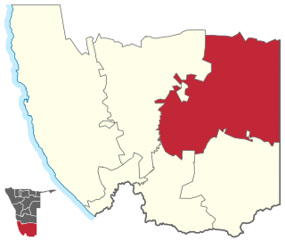
Erongo is one of the 14 regions of Namibia. The capital is Swakopmund. It is named after Mount Erongo, a well-known landmark in Namibia and in this area. Erongo contains the municipalities of Walvis Bay, Swakopmund, Henties Bay and Omaruru, as well as the towns Arandis, Karibib and Usakos. All the main centres within this region are connected by paved roads.

Sibbinda Constituency is an electoral district of Namibia that is located in the Zambezi Region. Its centre is Sibinda which is a settlement 63 kilometres out of Katima Mulilo. The constituency has a population of 11,112 people. In the 2020 Regional Council Elections, there were 6,248 registered voters.

Omaruru is a town in the Erongo Region of central Namibia. The town has 14,000 inhabitants and encompasses 352 square kilometres (136 sq mi) of land. It is situated near Mount Erongo, on the usually dry Omaruru River. It is located on the main paved road from Swakopmund to Otjiwarongo. The name in the Otjiherero language means 'bitter milk', as Herero cattle herds used to graze on the local bush that turned their milk bitter.

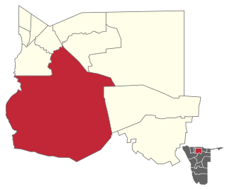
Arandis is a constituency in the Erongo Region of central-eastern Namibia. It had a population of 10,093 in 2011, an increase from 7,590 in 2001. As of 2020, the constituency had 8,888 registered voters.
Keetmanshoop Rural is an electoral constituency in the ǁKaras Region of Namibia. It contains the Krönlein suburb of Keetmanshoop and the villages of Koës and Aroab, the settlements of Seeheim and Klein Karas, as well as several farming communities in the area. The constituency office is situated in Aroab. It had a populations of 7,219 in 2011, up from 6,399 in 2001. As of 2020 the constituency had 6,398 registered voters.

Usakos is a town on the banks of river Khan, 140 kilometres north-east of Swakopmund in the Erongo Region of Namibia. It is located on the B2, the main road between the Walvis Bay and Johannesburg. The town has 3,000 inhabitants and owns 58 square kilometres (22 sq mi) of land.

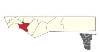
Omaruru is a constituency in the Erongo Region of central-eastern Namibia. Its district capital is the city of Omaruru. It had a population of 8,577 in 2011, up from 7,156 in 2001. As of 2020 the constituency had 6,672 registered voters.

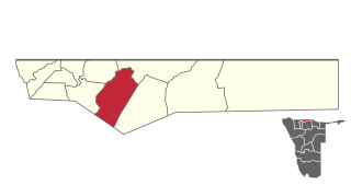
Karibib constituency is a constituency in the Erongo Region of Namibia. It had a population of 13,320 in 2011, an increase from 12,084 in 2001. The district capital is the town of Karibib. Smaller settlements that belong to Karibib constituency are Otjimbingwe, Usakos, and Wilhelmstal. As of 2020 the constituency had 9,617 registered voters.
Eenhana is an electoral constituency in the Ohangwena Region of Namibia, on the border to Angola. It had 24,193 inhabitants in 2004 and 15,912 registered voters in 2020. The district centre is the town of Eenhana.
Omulonga is a constituency in the Ohangwena Region of northern Namibia. It had 27,772 inhabitants in 2004 and 13,585 registered voters in 2020. The constituency office is located at Onamukulo, along the Ondobe-Oshigambo district road.

Ondobe is a constituency in the Ohangwena Region of Namibia. It had 32,726 inhabitants in 2004 and 16,286 registered voters in 2020.

Oshikango is a constituency in the town of Helao Nafidi in the Ohangwena Region of northern Namibia, on the border to Angola. It had 27,599 inhabitants in 2004 and 17,480 registered voters in 2020. It is named after the settlement of Oshikango, today part of the town Helao Nafidi.

Ogongo Constituency is an electoral constituency in the Omusati Region northern part of Namibia. It had 18,498 inhabitants in 2004 and 9,140 registered voters in 2020. Its district capital is the settlement of Ogongo. The constituency further contains the settlements of Eengolo, Eendombe, Pyamukuyu, Iipanda, Ombathi, and Omuthitu.

Ruacana Constituency is an electoral constituency in the Omusati Region of Namibia on the border to Angola. It had 10,722 inhabitants in 2004 and 9,285 registered voters in 2020. Its district capital is the town of Ruacana.

Oshakati East is an electoral constituency in the Oshana Region of Namibia. It comprises the eastern parts of the town of Oshakati. The constituency had 22,634 inhabitants in 2004 and 19,606 registered voters in 2020.

Oshakati West is an electoral constituency in the Oshana Region of Namibia. It contains the western parts of the town of Oshakati. The constituency had 20,015 inhabitants in 2004 and 15,120 registered voters in 2020.

Uukwiyu Constituency is an electoral constituency in the Oshana Region of Namibia. It had 11,894 inhabitants in 2004 and 6,620 registered voters in 2020. Its district capital is the settlement of Uukwiyu.
Omuthiyagwiipundi Constituency is an electoral constituency in the Oshikoto Region of Namibia. It had 21,884 inhabitants in 2004 and 15,220 registered voters in 2020. The constituency contains the settlements of Omuthiya and Iipundi. The area is predominantly rural.
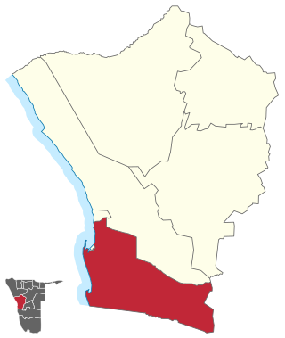
Walvis Bay Rural constituency is a constituency in the Erongo Region of Namibia. It comprises the rural area surrounding the constituency's district capital city of Walvis Bay, and additionally some streets on the outskirts of the city. It had a population of 26,916 in 2011, up from 16,293 in 2001. As of 2020 the constituency had 25,746 registered voters.

Walvis Bay Urban is a constituency in the Erongo Region of Namibia, comprising most of the city of Walvis Bay. It had a population of 35,828 in 2011, up from 27,941 in 2001. As of 2020 the constituency had 25,311 registered voters.
