
Erongo is one of the 14 regions of Namibia. The capital is Swakopmund. It is named after Mount Erongo, a well-known landmark in Namibia and in this area. Erongo contains the municipalities of Walvis Bay, Swakopmund, Henties Bay and Omaruru, as well as the towns Arandis, Karibib and Usakos. All the main centres within this region are connected by paved roads.

Omaruru is a city in the Erongo Region of central Namibia. The town has 14,000 inhabitants and encompasses 352 square kilometres (136 sq mi) of land. It is situated near Mount Erongo, on the usually dry Omaruru River. It is located on the main paved road from Swakopmund to Otjiwarongo. The name in the Otjiherero language means 'bitter milk', as Herero cattle herds used to graze on the local bush that turned their milk bitter.

Karibib is a town in the Erongo Region of western Namibia. It has 3,800 inhabitants and owns 97 square kilometres (37 sq mi) of town land. Karibib is the district capital of the Karibib electoral constituency. It is situated on the Khan River, halfway between Windhoek and Swakopmund on the B2, the main road between the Walvis Bay and Johannesburg. The town is known for its aragonite marble quarries and the Navachab Gold Mine.

Dâures is a constituency in the Erongo Region of Namibia. Its former name was Brandberg constituency, after the tallest mountain in Namibia, the Brandberg. It had a population of 11,350 in 2011, up from 10,289 in 2001. As of 2020 the constituency had 7,882 registered voters.

Arandis is a constituency in the Erongo Region of central-eastern Namibia. It had a population of 10,093 in 2011, an increase from 7,590 in 2001. As of 2020, the constituency had 8,888 registered voters.

Samora Machel Constituency is a constituency in Windhoek in the Khomas Region of central Namibia. The constituency is located across four northern suburbs of Windhoek: Wanaheda, Greenwell Matongo, Goreangab, and part of Havana. It had a population of 50,110 in 2011, up from 29,382 in 2001. As of 2020 it had 45,962 registered voters.

Outjo is an electoral constituency in the Kunene Region of Namibia. Its district capital is the town of Outjo, its population was 8,947 in 2004. As of 2020, it has 9,197 registered voters.

Kamanjab is a constituency in the Kunene Region of Namibia. In 2004, the population was 6,012. As of 2020, it has 4,862 registered voters. The district capital is the settlement of Kamanjab.

Usakos is a town on the banks of river Khan, 140 kilometres north-east of Swakopmund in the Erongo Region of Namibia. It is located on the B2, the main road between the Walvis Bay and Johannesburg. The town has 3,000 inhabitants and owns 58 square kilometres (22 sq mi) of land.

Rehoboth Rural is a constituency in the Hardap region of Namibia. It had a population of 7,288 in 2011, down from 7,524 in 2001. Among the settlements in Rehoboth Rural are Klein Aub, Khauxas, and Schlip. As of 2020, the constituency had 4,701 registered voters.

Rehoboth Urban East is an electoral constituency in the Hardap region of Namibia, comprising the suburbs of Rehoboth that are situated to the east of the national road B1. It had a population of 18,035 in 2011, up from 12,891 in 2001. As of 2020 the constituency had 12,112 registered voters.

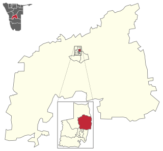
Omaruru is a constituency in the Erongo Region of central-eastern Namibia. Its district capital is the city of Omaruru. It had a population of 8,577 in 2011, up from 7,156 in 2001. As of 2020 the constituency had 6,672 registered voters.

Arandis is a town in the Erongo Region of western central Namibia. It has been called the Uranium Capital of the World as it is located just 15 km outside the world's largest open-pit uranium mine, the Rössing Uranium Mine.
Tobias Hainyeko constituency is an electoral constituency in Windhoek, the capital of Namibia. It had a population of 45,912 in 2011, up from 34,348 in 2001. As of 2020 it had 36,530 registered voters.
Sebastian Ignatius ǃGobs is a Namibian politician.

Sesfontein Constituency is an electoral constituency in the Kunene Region of Namibia. Its district capital is the settlement of Sesfontein. The constituency had a population of 7,358 in 2004. As of 2020, it has 5,614 registered voters.

Windhoek West Constituency is an electoral constituency in the Khomas Region of Namibia. It contains the affluent suburbs of Hochland Park, Pioneers Park, Academia, Cimbebasia, Rocky Crest, Windhoek North and Windhoek West. It had a population of 53,438 in 2011, up from 42,201 in 2001. As of 2020, it has 33,556 registered voters.

Swakopmund constituency is a constituency in the Erongo Region of Namibia. The constituency had a population of 44,725 in 2011, up from 26,310 in 2001. The coverage of the constituency and its district capital is the city of Swakopmund. As of 2020 the constituency had 35,668 registered voters.
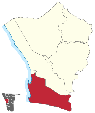
Walvis Bay Rural constituency is a constituency in the Erongo Region of Namibia. It comprises the rural area surrounding the constituency's district capital city of Walvis Bay, and additionally some streets on the outskirts of the city. It had a population of 26,916 in 2011, up from 16,293 in 2001. As of 2020 the constituency had 25,746 registered voters.

Walvis Bay Urban is a constituency in the Erongo Region of Namibia, comprising most of the city of Walvis Bay. It had a population of 35,828 in 2011, up from 27,941 in 2001. As of 2020 the constituency had 25,311 registered voters.
