
Gabú region is the easternmost region in Guinea-Bissau. Its capital is Gabú. The region borders Senegal to the north, Guinea to the east and south and the Guinea-Bissau regions of Tombali and Bafatá to the west. It covers an area of 9,150 km2, making it the largest of Guinea-Bissau's administrative regions. It is an inland region covered with savannah or light savannah woodland and receives an annual rainfall of more than 2,000 mm (79 in).
Sampa is a town in the Bono Region of Ghana, on the border with Côte d'Ivoire. It is the capital of Jaman North District and was formerly the site of a slave market. It was also the capital of the Akan State of Gyaaman in the late 15th century. It is the largest border town in Ghana with a population of over 36,000. It is the principal town of the Nafana ethnic group. It is the leading producer of cashews in Ghana.

Berekum, nicknamed "The Golden City", is a city and the capital of Berekum East Municipal in the Bono Region of Ghana. The city has a population of 62,364 as of 2012. The native language of the Berekum people is the Bono Twi. As of 2020, the Omanhene of the city is Daasebre Dr. Amankona Diawuo II.

Dormaa Ahenkro is a town and also the capital of Dormaa Traditional Area Dormaa Municipal of the Bono Region, in Ghana. Dormaa Ahenkro has a historical reference for their brave warlords. Dormaa Ahenkro is the capital for the Dormaa traditional area and serves as the seat of the Paramount chief Oseadeeyo Nana Agyeman Badu II.

Jaman District is a former district that was located in Brong-Ahafo Region, Ghana. Originally created as an ordinary district assembly on 10 March 1989 when it was known as Jaman District, which was created from the former Berekum-Jaman District Council. However on 12 November 2003, it was split off into two new districts: Jaman South District and Jaman North District. The district assembly was located in the western part of Brong-Ahafo Region and had Berekum as its capital town.

Jaman South Municipal District is one of the twelve (12) districts in Bono Region, Ghana. Originally known as Jaman District on March 10, 1989, after being created from the former Berekum-Jaman District within the then-larger Brong-Ahafo Region. Later on, part of the district was split off to create Jaman North District on November 12, 2003; thus the remaining original part became Jaman South District. It was later upgraded to municipal status in November 2017, and renamed as Jaman South Municipal District. The municipality is located in the western part of Bono Region and has Drobo as its capital town.
Berekum-Jaman District is a former district council that was located in Brong-Ahafo Region, Ghana. Originally created as an ordinary district assembly in 1975. However in 10 March 1989, it was split off into two new district assemblies: Berekum District and Jaman District. The district assembly was located in the western part of Brong-Ahafo Region and had Berekum as its capital town.

Bawku Municipal District is one of the fifteen districts in Upper East Region, Ghana. Originally created as an ordinary district assembly in 1988 when it was known as Bawku East District; which was established by Legislative Instrument (L.I.) 1439, until the southern part of the district was split off by a decree of president John Agyekum Kufuor in August 2004 to create Garu-Tempane District; thus the remaining part was elevated to municipal district assembly status on the same year to become Bawku Municipal District. However, on 28 June 2012, two parts of the district were later split off to create Binduri District and Pusiga District respectively; thus the remaining part has been retained as Bawku Municipal District. The municipality is located in the eastern part of Upper East Region and has Bawku as its capital town.
Wenchi Municipal District is one of the twelve districts in Bono Region, Ghana. Originally created as an ordinary district assembly in 1988 when it was known as Wenchi District, until the western part of the district was split off to create Tain District on 12 November 2003 ; thus the remaining part has been retained as Wenchi District. It was later elevated to municipal district assembly status and has been renamed as Wenchi Municipal District on 29 February 2008. The municipality is located in the northeast part of Bono Region and has Wenchi as its capital town.

Elubo is a town in the Jomoro district, a district in the Western Region of Ghana, and is located near the border with the Ivory Coast. 2021 census indicate that, Elubo have a settlement population of 23,952 people. The current Omanhene of Elubo is Nana Kesse Panyin III. The mayor of the town, along with the district, is Hon. Louisa Iris Arde.
Berekum East Municipal District is one of the twelve districts in Bono Region, Ghana. Originally it was formerly part of the then-larger Berekum District on 10 March 1989, which was created from the former Berekum-Jaman District Council. It was later upgraded to municipal district assembly status and has been renamed as Berekum Municipal District on 29 February 2008; until the western part of the district was split off to create Berekum West District on 15 March 2018; thus the remaining part has been renamed as Berekum East Municipal District. The municipality is located in the western part of Bono Region and has Berekum as its capital town.

Kulango is a Niger–Congo language spoken in Ivory Coast and across the border in Ghana. It is one of the Kulango languages, and it may be classified as a Gur language. There are two principal varieties distinct enough to be considered separate languages: the Kulango of Bondoukou (Bonduku), also known as Goutougo locally, and that of Bouna (Buna). Ethnologue reports that Bouna-dialect speakers understand Bondoukou, but not the reverse. Bouna, in addition, has the subdialects Sekwa and Nabanj. In Ghana, the principal towns in which the language is spoken are Badu and Seikwa, both in the Tain District, and Buni in the Jaman North district, all in the Bono region of Ghana. In addition, there are smaller towns and villages closer to Wenchi in the Bono region and Techiman in the Bono East region where this language is spoken. Among these are Asubingya (Asubinja) and Nkonsia. The Koulango are matrilineal like the Akans and possess similar cultural practices.
Banda District is one of the twelve districts in Bono Region, Ghana. Originally it was formerly part of the then-larger Tain District on 17 February 2004; until the northern part of the district was split off to create Banda District on 28 June 2012; thus the remaining part has been retained as Tain District. The district assembly is located in the northeast part of Bono Region and has Banda Ahenkro as its capital town.
Japekrom is the Municipal Capital of Jaman South Municipality of the Bono Region of Ghana. It has been an important town since the colonial Gold Coast days in Ghana's History, then referred to as Pruano but spelled as Pulliano in colonial Gold Coast maps. The Japekromhene is part of Asanteman council. The township was built on a foundation of solid stone and as a result of resistance to any form of suppression or oppression. Traditional leaders of the Japekrom strongly uphold the principles of truth, fairness, hard work, a welcoming heart, inclusion and preservation of culture. The people of Japekrom are very welcoming of people from other tribes and cultures.
The Western North region is one of the six new regions of Ghana created in 2019. The region is bounded by the Ivory Coast on the west, the Central region in the southeast, and the Ashanti, Ahafo, Bono East and Bono regions in the north. The Western North region has the highest rainfall in Ghana, lush green hills, and fertile soils. There are numerous small and large-scale gold mines companies in the region. The ethnic culture of the region is dominated by the Sefwis. The main languages spoken are Sefwi, Akan, French and English.
Stevens Siaka is a Ghanaian politician and member of the Seventh Parliament of the Fourth Republic of Ghana representing the Jaman North constituency in the Bono Region on the ticket of the New Patriotic Party. Siaka Stevens was a former chairman of the Parliamentary Select Committee on Education and he was the Deputy Minister for Bono Region from 26 March 2019 till January 2021.
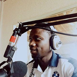
Victor Ferkah is a Ghanaian broadcast journalist and radio personality who currently works for Sky FM (96.7) Ghana as part of his community service. Aside from radio, he works full-time as a senior administrative assistant at the University of Energy and Natural Resources in Sunyani. Ferkah is also the Founder and CEO of the Ferk Relief Foundation, a non-governmental organization based in Sunyani, Ghana. He is a graduate of the Catholic University College of Ghana (Fiapre) and a student of law.

Berekum Municipal District is a former district located in Brong-Ahafo Region, Ghana. It was originally created as an ordinary district assembly on 10 March 1989, when it was known as Berekum District, which was created from the former Berekum-Jaman District Council. Later it was elevated to municipal district assembly status on 29 February 2008 to become Berekum Municipal District. However, on 15 March 2018, it was split off into two new districts: Berekum East Municipal District and Berekum West District. The municipality was located in the western part of Brong-Ahafo Region and had Berekum as its capital town.
Berekum West District is one of the twelve districts in Bono Region, Ghana. Originally it was formerly part of the then-larger Berekum District on 10 March 1989, which was created from the former Berekum-Jaman District Council ; until the western part of the district was split off to create Berekum West District on 15 March 2018; thus the remaining part has been renamed as Berekum East Municipal District. The district assembly is located in the western part of Bono Region and has Jinijini as its capital town.

Frederick Yaw Ahenkwah is a Ghanaian politician and member of parliament for the Jaman North constituency in the Bono region of Ghana.

