There are three terrestrial national parks and six marine national parks in the Seychelles. [1] The parks are administered by Seychelles National Environment Commission (SNEC), which falls under the Department of the Environment. [2]

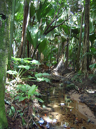
There are three terrestrial national parks and six marine national parks in the Seychelles. [1] The parks are administered by Seychelles National Environment Commission (SNEC), which falls under the Department of the Environment. [2]

The Glorieuses or Glorioso Islands are a group of French islands and rocks totaling 5 square kilometres. They are controlled by France as part of the Scattered Islands in the Indian Ocean in the French Southern and Antarctic Lands, a French overseas territory, but are also claimed by Comoros, Madagascar and formerly by Seychelles. They are geographically part of the Comoro Islands between the French overseas region of Mayotte and the nation of Madagascar.

Seychelles, officially the Republic of Seychelles, is an archipelagic state and country consisting of 115 islands in the Indian Ocean. Its capital and largest city, Victoria, is 1,500 kilometres east of mainland Africa. Nearby island countries and territories include the Comoros, Madagascar, Mauritius, and the French overseas departments of Mayotte and Réunion to the south; and Maldives and the Chagos Archipelago to the east. It is the least populated sovereign African country, with an estimated 2020 population of 100,092.

Seychelles is a small island country located in the Sea of Zanj due north of Madagascar, with Antsiranana as its nearest foreign city. Seychelles lies between approximately 4ºS and 10ºS and 46ºE and 54ºE. The nation is an archipelago of 115 tropical islands, some granite and some coral. the majority of which are small and uninhabited. The landmass is only 452 km2 (175 sq mi), but the islands are spread wide over an exclusive economic zone of 1,336,559 km2 (516,048 sq mi). About 90 percent of the population of 90,000 live on Mahé, 9 percent on Praslin and La Digue. Around a third of the land area is the island of Mahé and a further third the atoll of Aldabra.

Aldabra is the world's second-largest coral atoll, lying southeast of the continent of Africa. It is part of the Aldabra Group of islands in the Indian Ocean that are part of the Outer Islands of the Seychelles, with a distance of 1,120 km (700 mi) southwest of the capital, Victoria on Mahé Island.

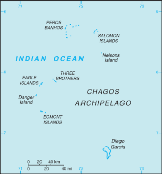
The British Indian Ocean Territory (BIOT) is an archipelago of 55 islands in the Indian Ocean, located south of India. It is situated approximately halfway between Africa and Indonesia. The islands form a semicircular group with an open sea towards the east. The largest, Diego Garcia, is located at the southern extreme end. It measures 60 square kilometres (23 sq mi) and accounts for almost three-quarters of the total land area of the territory. Diego Garcia is the only inhabited island and is home to the joint UK-US naval support facility. Other islands within the archipelago include Danger Island, Three Brothers Islands, Nelson Island, and Peros Banhos, as well as the island groups of the Egmont Islands, Eagle Islands, and the Salomon Islands.

The Aldabra giant tortoise is a species of tortoise in the family Testudinidae. The species is endemic to the Seychelles, with the nominate subspecies, A. g. gigantea native to Aldabra atoll. It is one of the largest tortoises in the world. Historically, giant tortoises were found on many of the western Indian Ocean islands, as well as Madagascar, and the fossil record indicates giant tortoises once occurred on every continent and many islands with the exception of Australia and Antarctica.
Curieuse Island is a small granitic island 1.13 sq mi (2.9 km2) in the Seychelles close to the north coast of the island of Praslin. Curieuse is notable for its bare red earth intermingled with the unique coco de mer palms, one of the cultural icons of the Seychelles, only growing on the two neighboring islands.

Desroches Island or Île Desroches is the main island of the Amirante Islands, part of the Outer Islands of the Seychelles.

Mont Fleuri is an administrative district of Seychelles with its main part located on the island of Mahé. It also includes the six islands of the Sainte Anne Marine National Park and two islets further east.
Sainte Anne Marine National Park lies about 5 km from Victoria, the capital city of the Seychelles, and encompasses eight small islands.
The wildlife of Mauritius consists of its flora and fauna. Mauritius is located in the Indian Ocean to the east of Madagascar. Due to its isolation, it has a relatively low diversity of wildlife; however, a high proportion of these are endemic species occurring nowhere else in the world. Many of these are now threatened with extinction because of human activities including habitat destruction and the introduction of non-native species. Some have already become extinct, most famously the dodo which disappeared in the 17th century.

The Granitic Seychelles are the islands in Seychelles which lie in central position on the Seychelles Bank and are composed of granite rock. They make up the majority of the Inner Islands, which in addition include the coral islands along of the rim of the Seychelles Bank, namely Bird Island and Denis Island. The Granitic Seychelles contrast with the Coralline Seychelles or the Outer Islands, several island groups made up of low coral islands with dry, infertile soils.

The wildlife of Seychelles comprises the flora and fauna of the Seychelles islands off the eastern coast of Africa in the western Indian Ocean.

Tourism is the most important nongovernment sector of Seychelles' economy. About 15 percent of the formal work force is directly employed in tourism, and employment in construction, banking, transportation, and other activities is closely tied to the tourist industry. Tourists enjoy the Seychelles' coral beaches and opportunities for water sports. Wildlife in the archipelago is also a major attraction.
Articles related to Seychelles include:

The Mahé highlands and surrounding areas Important Bird Area occupy the central and north-western part of the island of Mahé in the Seychelles archipelago of the western Indian Ocean.
Smooth Island is an island in the Australian state of South Australia located off the west coast of Eyre Peninsula about 52 kilometres south west of the town of Ceduna. It is both part of a local group of islands known as the Isles of St Francis group and a larger group known as the Nuyts Archipelago. It has enjoyed protected area status since the 1960s and since 2011, it has been part of the Nuyts Archipelago Wilderness Protection Area.
Pearson Isles is an island group located in the Australian state of South Australia about 65 kilometres to 72 kilometres west south-west of Cape Finniss on the west coast of Eyre Peninsula within the larger island group, the Investigator Group. The group was discovered and named by Matthew Flinders on 13 February 1802. The group has four members - Pearson Island, a pair of islands known as the Veteran Isles and Dorothee Island. The island group has enjoyed protected area status starting in 1916 and since 2011, it has been part of the Investigator Group Wilderness Protection Area. The island group is notable as a venue for scientific research.
Dorothee Island is an island in the Australian state of South Australia which is part of the Pearson Isles which itself is part of the larger island grouping known as the Investigator Group. It is located about 69 kilometres west south-west of Cape Finniss on the west coast of Eyre Peninsula. It was discovered as part of the Pearson Isles by Matthew Flinders on 13 February 1802. The island was given its name in August 1969 in order to preserve a name used within the locality by the Baudin expedition. The island has enjoyed protected area status since at least 1972 and since 2011, it been part of the Investigator Group Wilderness Protection Area.
Veteran Isles is a pair of islands in the Australian state of South Australia which is part of the Pearson Isles which itself is part of the larger island group known as the Investigator Group. It is located about 69 kilometres west south-west of Cape Finniss on the west coast of Eyre Peninsula. It was discovered as part of the Pearson Isles by Matthew Flinders on 13 February 1802. The island was given its name in August 1969 in order to preserve a name used within the locality by the Baudin expedition. The island has enjoyed protected area status since at least 1972 and since 2011, it been part of the Investigator Group Wilderness Protection Area.