
Mongolia is a landlocked country in East Asia, located between China and Russia. The terrain is one of mountains and rolling plateaus, with a high degree of relief. The total land area of Mongolia is 1,564,116 square kilometres. Overall, the land slopes from the high Altai Mountains of the west and the north to plains and depressions in the east and the south. The Khüiten Peak in extreme western Mongolia on the Chinese border is the highest point. The lowest point is at 560 m (1,840 ft), is the Hoh Nuur or lake Huh. The country has an average elevation of 1,580 m (5,180 ft).

The Daurian Nature Reserve is a Russian zapovednik situated in the southern part of Zabaykalsky Krai in Siberia, Russia, close to the border with Mongolia. It is part of a World Heritage Site named "The Landscapes of Dauria".
Alkhanay National Park encompasses the area around Mt. Alkhanai, a central focus and sacred mountain to the Buryats people, who today are the largest indigenous group in Siberia. Mt. Alkanai has been adopted as sacred by later Mongols, shamanistic people, and Buddhists. The Dalai Lama has made two unofficial visits to Alkhanay. The area takes its name from an old legend, in which a princess took refuge from her pursuers on the top of the mountain, defiantly shouting as they approached, "kill me!", which translates to "Alkhanai" in the local language. Despite the ancient name, the focus today of Buddhist pilgrims as they ascend the mountain pathway is one of peacefulness and healing. The park seeks to balance support for continued pilgrimage to the rock landforms and mineral springs, with conservation of nature and recreational tourism. Alkhanay NP is located in the Trans-Baikal region of Russia, about 300 miles east of the lake, and 75 miles north of Mongolia's northern border. It is in the administrative region of Aginsky District, Zabaykalsky Krai.
Chikoy National Park was officially created in 2014, on the mountain-steppe border region of south-central Siberia and Mongolia. It is in the Krasnochikoysky District of the Zabaykalsky ("Trans-Baikal") administrative region of Russia. This places the park about 250 miles southeast of Lake Baikal, on the edge of the Lake Baikal ecoregion. The stated purpose for creating the park is the "preservation of unique natural complexes in the upper reaches of the river Chikoy". While tourism and sport fishing will be encouraged, hunting and roads will be prohibited.

Saylyugemsky National Park sits at the mountainous "X" where the borders of Russia, Kazakhstan, Mongolia and China meet in the Altai Mountains of central Asia. Because of its remoteness and position at the meeting points of mountains, steppes, desert and forest, it is a globally important natural reserve for biodiversity. The park was formally established in 2010–2012, with a particular purpose of protecting the vulnerable Altai argali mountain sheep and the endangered Snow leopard. The component Saylyugem Mountains are a ridge of the Altai, and stretch to the northeast to the Sayan Mountains. The climate is cold and semi-arid. Administratively, the park is located in the Kosh-Agachsky District of the Altai Republic. While ecotourism has a stated role, visits to the territory currently require special passes from park administration, and activities are limited to roads and trails.
Shushensky Bor National Park consists of two representative forests in the extreme southwest of Siberia, in the northern foothills of the Western Sayan Mountains. The northern section is forest-steppe in character, while the southern section is mountain conifer forest. The southern section is bordered on two sides by the Yenisei river reservoir behind the Sayano-Shushenskaya Dam, the largest hydroelectric dam in Russia. The forest has both high biodiversity value and recreational value for hikers and tourists. It is located in the Shushensky District of Krasnoyarsk Krai.

Samarskaya Luka National Park covers most of the peninsula formed by the 180-degree bend of the Volga River as it flows around the Zhiguli Mountains, near the cities of Samara and Zhigulyovsk in the Stavropolsky District, Samara Oblast. The north shore of the bend is on the Kuybyshev Reservoir, the south side is on the Saratov Reservoir, and on the north it has a border with Zhiguli Nature Reserve. The park is culturally important because of its centrality to a range of peoples back to ancient times, and to its scientific value resulting from the biodiversity of its closely placed variety of habitats. The territory is part of the Middle Volga Integrated Biosphere Reserve.

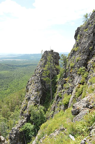
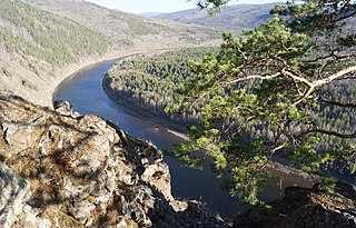
Sokhondo Nature Reserve is a Russian 'zapovednik' in the south of Eastern Siberia, 25 km north of the border with Mongolia. It is the farthest source of the Amur River, and is centered on the Sokhondo Mountain massif, in the highest sector of the Khentei-Chikoy Highlands in the Khentei Range mountain range. The Sokhondo massif has two peaks, and is an ancient volcano. Also within the borders are many lakes of glacial origin. In 1985, Sokhondo was named a UNESCO MAB Biosphere Reserve. The reserve is situated in the Chita district of Chita Oblast.
The Transbaikal conifer forests ecoregion covers a 1,000 km by 1,000 km region of mountainous southern taiga stretching east and south from the shores of Lake Baikal in the Southern Siberia region of Russia, and including part of northern Mongolia. Historically, the area has been called "Dauria", or Transbaikal. It is in the Palearctic realm, and mostly in the boreal forests/taiga biome with a subarctic, humid climate. It covers 200,465 km2 (77,400 sq mi).

Sayano-Shushenski Nature Reserve is a Russian 'zapovednik' reserve in a remote area of the West Sayan Mountains of south Siberia. It is on the southern bank of the Yenisei River along the Sayano-Shushenskoye reservoir. The reserve thus protects a large section of the wooded, mountainous territory above the reservoir created by the Sayano-Shushenskaya Dam, the largest power plant in Russia. Both the reserve and the dam were established 1976, and a major purpose of the reserve besides conservation is the study of the ecological effects of a large reservoir on the local ecology. The reserve covers an area of 390,368 ha (1,507.22 sq mi). It is situated in the Shushensky District of Krasnoyarsk Krai.

Kuznetsk Alatau Nature Reserve is a Russian 'zapovednik' on the Kuznetsk Alatau, a mountain ridge in the Altai-Sayan mountain region in southwestern Siberia. The Kuznetsk Alatau consists of several ranges of medium height, between which there are river valleys. The reserve is in the watershed of the Tom River and the Chuly River. It is spread over three districts of Kemerovo Oblast: Tisulsky District, Mezhdurechensky District, and Novokuznetsky District. The reserve was established in 1989 and covers an area of 412,900 ha (1,594 sq mi).

The Da Hinggan-Dzhagdy Mountains conifer forests ecoregion covers the Greater Khingan Mountains of Northeast China, and across the border north into the Russian Far East where it follows the mountain ridge for another 500 km to the east. The mountain forests exhibit a floral community called "Daurian flora", a combination of the Siberian taiga to the north and the Manchurian floral types to the south. The eastern slopes are steep and drained by many rivers, the western slopes are gentler, and there are grasslands on some slopes. The ecoregion is in the Palearctic realm, with a subarctic climate. It covers 35,199,998 km2 (13,590,795 sq mi).

The Daurian forest steppe ecoregion is a band of grassland, shrub terrain, and mixed forests in northeast Mongolia and the region of Siberia, Russia that follows the course of the Onon River and Ulz River, and part of the northwestern China. The region has been described as a "sea of grass that forms the best and most intact example of an undisturbed steppe ecosystem and is also one of the last areas in the Palearctic that still supports stable herds of larger vertebrates" in a semi-mountainous area. The area also has flat wetlands that are important to migratory birds. The ecoregion is in the Palearctic realm, with a dry-winter subarctic climate that borders on a very cold semi-arid climate (BSk) in its southwestern parts. It covers 209,012 km2 (80,700 sq mi).

The Selenge–Orkhon forest steppe ecoregion stretches across north central Mongolia, and follows the Selenga River northeast into Russia. The ecoregion is itself at high elevations, but surrounded by higher mountain ranges. As a transition zone between taiga and steppe, it features conifer forests on the north slopes of mountains, and pine/aspen stands on southern slopes. It has an area of 227,660 square kilometres (87,900 sq mi).

The Northeast China Plain deciduous forests ecoregion covers the flat interior Northeast China Plain and neighboring adjacent northwestern North Korea, in the region historically known as Manchuria. The plain is surrounded by mountains on the north and east, and supports some of China's largest forest tracts. There are also extensive low-lying wetlands, which support important bird populations.
The Manchurian mixed forests ecoregion covers the forested hills surrounding the river plains of northern China, Russia, North Korea, and South Korea. The ecoregion supports a number of rare species due to the relative isolation, the diversity of habitat, with mixed forests of deciduous Mongolian oak and conifers of Korean pine. Because mountains rise above the region on three sides, with plains and wetlands below, the area supports high biodiversity as a transition zone.
The Khangai Mountains alpine meadows ecoregion runs along the central ridge of the Khangai Mountains in central Mongolia. The slopes to the north are conifer forests, the lowlands to the south are semi-arid steppe. The Khangai are an "island" mountain range surrounded by lower forest steppe and semi-arid regions of central Mongolia. Most of the region is now protected by Tarvagatai Nuruu National Park and Khangai Nuruu National Park.

The Khangai Mountains conifer forests ecoregion covers the northern slopes of the Khangai Mountains in central Mongolia. The montane taiga supports a populations of elk, deer, wild boar, wolves, and brown bear. The diversity of plants and animals has benefited from the relative isolation and low human population of the area.

Khangai Nuruu National Park stretches in a west-to-east band across the middle of the Khangai Mountains, with the eastern half following the upper Orkhon River valley. There are a variety of habitat types in the park: steppe, riparian forests, larch taiga, and alpine meadows.
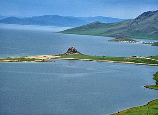
Khorgo-Terkhiin Tsagaan Nuur National Park covers the picturesque Terkhiin Tsagaan Lake and the nearby Khorgo Mountain in the north central Khangai Mountains of Mongolia. The marshes along the west end of the lake are an important breeding and staging area for birds. The park is located in Tariat District of Arkhangai Province.

