National Parks of Costa Rica | |||||||||
Manuel Antonio National Park | |||||||||
First Park | Poás Volcano National Park, 1955 | ||||||||
Smallest Park | San Lucas Island National Park, 4.49 km2 | ||||||||
Largest Park | La Amistad International Park, 1991 km2 | ||||||||
Governing body | SINAC |
In 2023 thirty National Parks of Costa Rica are managed under the umbrella of SINAC (Sistema Nacional de Areas de Conservacion), a department of Costa Rica's Ministry of Environment and Energy (MINAE). All told, Costa Rica's protected areas, including national parks, encompass more than 25% of the country's total land area. [1] Many of these protected areas are national parks.
Costa Rica's progressive policies on environmental protection and sustainable ecotourism in the National Parks System have been lauded as a model for other countries. The rainforests, tropical forests, marine areas and wetlands of Costa Rica are the subject of many university and scientific organization studies. The enrichment of the world's knowledge of these important habitats is an invaluable contribution from the National Parks System of Costa Rica.
The Cordillera de Talamanca is home to an impressive collection of national parks and other preserved areas, including the La Amistad International Park, which extends into Panama. On the southern Osa Peninsula is the internationally renowned Corcovado National Park, which preserves a remnant of sizeable lowland tropical rainforest that is unique in the world. Manuel Antonio National Park was listed by Forbes in 2011 among the world's 12 most beautiful national parks. [2]
The Camino de Costa Rica is a 280 km long hiking trail across Costa Rica. It runs from the Atlantic Ocean (Caribbean coast), the southernmost part of the Tortuguero Canals, up the mountain and through indigenous territory near the Barbilla National Park and through valleys and mountain ranges of the central region of the country, just south of the Turrialba and Irazu Volcanos and through the Los Santos coffee region down to the Pacific coast in Quepos.
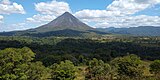
Park | Coordinates [3] | Area [4] | Attractions |
---|---|---|---|
Arenal Volcano | 10°28′N84°42′W / 10.46°N 84.70°W | 12,124 ha (29,960 acres) | Arenal Volcano, 1,633 m (5,358 ft) in elevation, has been active almost continuously since 1968. A second volcano, Chato, has a lake in the crater. [4] [5] |
Ballena Marine | 9°10′N83°45′W / 9.16°N 83.75°W | 5,330 ha (13,200 acres) | Located on the Pacific Ocean. 5,160 ha (12,800 acres) of park is water with seasonal visits by humpback whales, dolphins, and other marine life. [6] |
Barbilla | 9°59′N83°27′W / 9.98°N 83.45°W | 11,955 ha (29,540 acres) | Elevations from 110 m (360 ft) to 1,600 m (5,200 ft), The park features foot travel in wet and very wet rain forests and pumas, jaguars, ocelots, and tapirs. [7] |
Barra Honda | 10°11′N85°22′W / 10.18°N 85.37°W | 2,295 ha (5,670 acres) | The park features extensive limestone caves, some unexplored, with stalactite and stalagmite formations. [8] |
Braulio Carrillo | 10°13′N84°01′W / 10.21°N 84.02°W | 50,000 ha (120,000 acres) | Steep topography, several volcanoes, rain forests, and proximity to the capital city of San José are attractions. The highest elevation is 2,906 m (9,534 ft) [9] |
Cahuita | 9°44′N92°50′W / 9.74°N 92.84°W | 57,932 ha (143,150 acres) | On the Atlantic coast, 55,200 ha (136,000 acres) of the park is water. The park includes Costa Rica's largest coral reef and preserves marine life. [10] |
Carara | 9°47′N84°37′W / 9.78°N 84.61°W | 5,800 ha (14,000 acres) | 
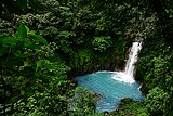
Near the Pacific Ocean, Carara is the northernmost coastal rain forest in Costa Rica. The park is popular with bird watchers and has a large population of scarlet macaws. [11] |
Chirripó | 9°44′N84°37′W / 9.73°N 84.61°W | 50,150 ha (123,900 acres) | 
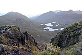
Chirripó features Costa Rica's highest mountain with an elevation of 3,820 m (12,530 ft). Alpine tundra (Costa Rican Paramo) and glacial lakes are found at elevations above 3,000 m (9,800 ft) [12] |
Cocos Island | 5°32′N87°04′W / 5.53°N 87.06°W | 2,310 ha (5,700 acres) | A UNESCO World Heritage Site, Cocos Island is 550 km (340 miles) off the Pacific Ocean coast of Costa Rica and features marine life, evergreen forests, and waterfalls. [13] |
Corcovado | 8°32′N83°34′W / 8.54°N 83.57°W | 41,788 ha (103,260 acres) | On the Pacific coast, most of the park is shallow lagoons, mangrove forests, beaches, and low altitude cloud forests. Access is only with approved guide. [14] |
Diriá | 10°10′N85°35′W / 10.16°N 85.58°W | 5,429 ha (13,420 acres) | The park features wetlands and forests. [15] |
Guanacaste | 10°58′N85°31′W / 10.96°N 85.51°W | 33,796 ha (83,510 acres) | Part of the Guancaste World Heritage Site, the park has two volcanos, Orosi and Cacao; dry, wet, and cloud forests; and a large population of collared peccary. Access is through Santa Rosa National Park. [16] |
Irazú Volcano | 9°58′48″N63°53′42″W / 9.98°N 63.895°W | 2,000 ha (4,900 acres) | Irazú is Costa Rica's highest volcano at 3,432 m (11,260 ft). A paved road reaches to near the summit from where both the Atlantic and Pacific coasts can be seen. [17] |
Juan Castro Blanco | 10°29′N84°20′W / 10.48°N 84.33°W | 14,308 ha (35,360 acres) | The mountainous park has volcanoic cones and vents, Lake Pozo Verde, waterfalls, and many bird species, including quetzals. [18] |
La Amistad | 9°25′N82°59′W / 9.42°N 82.98°W | 199,147 ha (492,100 acres) | A UNESCO World Heritage Site and the largest wilderness area in Costa Rica, the park extends into Panama. Rugged terrain and some of the highest mountains in the country are features. Bio-diversity is outstanding for both flora and fauna. [19] |
La Cangreja | 0°42′N84°24′W / 0.70°N 84.40°W | 2,570 ha (6,400 acres) | Forty-four species of plants are endemic to Costa Rica and crystalline water from the sources of two rivers. [20] |
Las Baulas | 10°20′N85°51′W / 10.33°N 85.85°W | 90,100 ha (223,000 acres) | Most of this park is ocean. The beaches of Las Baulas are the largest nesting ground in the world for sea turtles. The coastal area of the park features mangrove forests. [21] |
Los Quetzales | 9°37′N83°49′W / 9.61°N 83.82°W | 4,117 ha (10,170 acres) | A mountainous park reaching an elevation of 3,190 m (10,470 ft). As the name indicates the quetzal bird is the main attraction. [22] |
Manuel Antonio | 9°23′N84°08′W / 9.39°N 84.14°W | 27,587 ha (68,170 acres) | One of the few remaining homes of the Grey-crowned Central American squirrel monkey, an endangered species. Most of the park is ocean. Twelve islands shelter marine birds. [23] |
Miravelles Jorge Manuel Dengo | 10°45′N95°09′W / 10.75°N 95.15°W | 4,300 ha (11,000 acres) | The Miravalles Volcano rises to 2,028 m (6,654 ft). The Miravalles Geothermal Power Project is on the slopes of the volcano. [24] |
Palo Verde | 10°23′N85°20′W / 10.38°N 85.33°W | 18,332 ha (45,300 acres) | Decalared a wetland of international importance, about one-half of the park is water or wetland, hosting migratory and non-migratory aquatic birds. [25] |
Piedras Blancas | 8°43′N83°16′W / 8.71°N 83.27°W | 15,350 ha (37,900 acres) | Rich as it is in biological life, Piedras Blancas is also part of the Osa Conservation Area along with several adjoining parks and reserves devoted to conservation. |
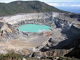
Poás Volcano | 10°12′N84°14′W / 10.20°N 84.23°W | 6,506 ha (16,080 acres) | The volcano, 2,708 m (8,885 ft) in elevation, has several fumaroles emitting gas and causing acid rain which has killed much of the vegetation and force frequent closure of the park. [26] |
Rincón de la Vieja Volcano | 10°46′N85°20′W / 10.77°N 85.34°W | 14,127 ha (34,910 acres) | The volcano, 1,916 m (6,286 ft) in elevation is continuously active with foot trails to nine volcanic cones, fumaroles, mud pits, and hot springs. [27] [28] |
Santa Rosa | 10°50′N85°43′W / 10.84°N 85.71°W | 39,322 ha (97,170 acres) | Santa Rosa protects a dry tropical forest and beaches with sea turtle nests. The park is the site of the Battle of Santa Rosa and military monuments. [29] |
San Lucas Island | 9°56′N84°55′W / 9.94°N 84.91°W | 472 ha (1,170 acres) | Located 2 km (1.2 miles) off shore in the Pacific Ocean, the park is a former prison and wildlife preserve. [30] |
Tapantí-Macizo de la Muerte | 9°46′N83°47′W / 9.76°N 83.78°W | 58,495 ha (144,540 acres) | Elevations up to 2,560 m (8,400 ft), rain forests, ancient oak and alder trees characterize this park in one of the rainiest parts of Costa Rica. [31] Precipitation exceeds 6,500 mm (260 in) annually. [32] |
Tenorio Volcano | 10°43′N84°59′W / 10.71°N 84.99°W | 12,905 ha (31,890 acres) | The park is characterized by cloud forests and rain forests. The volcano reaches an elevation of 1,917 m (6,289 ft). |
Tortuguero | 10°27′N83°34′W / 10.45°N 83.57°W | 76,397 ha (188,780 acres) | Two-thirds of the park is water. The park hosts the largest green turtle nesting beach in the Americas. Ninety-nine percent of the park is for preservation; one percent is open to visitors. [33] |
Turrialba Volcano | 10°01′N83°46′W / 10.02°N 83.77°W | 1,257 ha (3,110 acres) | Turrialba is the second highest volcano in Costa Rica with an elevation of 3,340 m (10,960 ft). The volcano is periodically active. [34] |
Total | 816,521 ha (2,017,670 acres) (including ocean) | The land area of national parks make up 13 percent of the area of Costa Rica and about one-half of the total protected land area in Costa Rica. | |
Rank | Park | Total visitors (2012–2022) [35] |
---|---|---|
1 | Manuel Antonio | 4,388,469 |
2 | Irazú Volcano | 2,732,394 |
3 | Poás Volcano | 2,503,944 |
4 | Marino Ballena | 1,878,848 |
5 | Tortaguero | 1,277,816 |
6 | Cahuita | 1,113,911 |
7 | Arenal Volcano | 1,010, 866 |
8 | Tenoro Volcano | 975,754 |
9 | Rincón de La Vieja Volcano | 769,719 |
10 | Corcovado | 551,101 |
11 | Santa Rosa | 425,388 |
12 | Carara | 398,910 |
13 | Tapanti-Macizo de la Muerte | 240,482 |
14 | Braulio Carrillo | 240,089 |
15 | Chirripó | 155,696 |
16 | Coco Island | 107,295 |
17 | Palo Verde | 68,591 |
18 | Barra Honda | 52,067 |
19 | Los Quetzales | 28,751 |
20 | San Lucas Island | 18,872 |
21 | Marino Las Baulas | 18,012 |
22 | Diriá | 16,300 |
23 | La Cangreja | 12,556 |
24 | La Amistad International Park | 7,985 |
25 | Turrialba Volcano | 7,234 |
26 | Barbilla | 4,157 |
27 | Piedras Blancas | 3,727 |
28 | Juan Castro Blanco | 732 |
29 | Guancaste | n/a |
30 | Miravalles Jorge Manuel Dengo | n/a |
Arenal Volcano is an active andesitic stratovolcano in north-western Costa Rica around 90 km (56 mi) northwest of San José, in the province of Alajuela, canton of San Carlos, and district of La Fortuna. The Arenal volcano measures at least 1,633 metres (5,358 ft) high. It is conically shaped with a crater 140 metres (460 ft) in diameter. Geologically, Arenal is considered a young volcano and it is estimated to be less than 7,500 years old. It is also known as "Pan de Azúcar", "Canaste", "Volcan Costa Rica", "Volcan Río Frío" or "Guatusos Peak".
Guanacaste is a province of Costa Rica located in the northwestern region of the country, along the coast of the Pacific Ocean. It is bordered by Nicaragua to the north, Alajuela Province to the east, and Puntarenas Province to the southeast. It is the most sparsely populated of all the provinces of Costa Rica. The province covers an area of 10,141 square kilometres (3,915 sq mi) and as of 2010, had a population of 354,154, with annual revenue of $2 billion.
The Irazú Volcano is an active volcano in Costa Rica, situated in the Cordillera Central close to the city of Cartago.
National System of Conservation Areas is part of the Ministry of Environment and Energy (MINAE) of Costa Rica. It is the administrator for the nation's national parks, conservation areas, and other protected natural areas.
Tapantí - Cerro de la Muerte Massif National Park,, is a national park in the Central Conservation Area of Costa Rica located on the edge of the Talamanca Range, near Cartago. It protects forests to the north of Chirripó National Park, and also contains part of the Orosí River. The area known as Cerro de la Muerte Massif was added to the park on January 14, 2000.
The Cordillera de Guanacaste, also called Guanacaste Cordillera, are a volcanic mountain range in northern Costa Rica near the border with Nicaragua. The mountain range stretches 110 km from northwest to the southeast and contains mostly complex stratovolcanoes. The range forms part of the southern region of the Continental Divide, with the highest peak is the stratovolcano Miravalles at 2,028 m.
Arenal Huetar Norte Conservation Area, is an administrative area which is managed by SINAC for the purposes of conservation in the northern part of Costa Rica. It contains two national park, a forest reserve and four wildlife refuges.
Rincón de la Vieja National Park, is a National Park in Guanacaste Province of the northwestern part of Costa Rica.
Arenal Tempisque Conservation Area, is an administrative area which is managed by SINAC for the purposes of conservation in the northwest part of Costa Rica, near the Arenal Volcano and covering part of the Cordillera de Tilarán and Cordillera de Guanacaste. It contains a number of National Parks, Wildlife refuges and Protected Zones. The area was previously known as Arenal Tilarán Conservation Area.
Central Conservation Area, is an administrative area which is managed by SINAC for the purposes of conservation in the central part of Costa Rica, notably the volcanic areas of the Cordillera Central. It contains six National Parks, several wildlife refuges and other types of nature reserves.
The Talamancan montane forests ecoregion, in the tropical moist broadleaf forest biome, are in montane Costa Rica and western Panama in Central America.
Tourism in Costa Rica has been one of the fastest growing economic sectors of the country and by 1995 became the largest foreign exchange earner. Since 1999, tourism has earned more foreign exchange than bananas, pineapples and coffee exports combined. The tourism boom began in 1987, with the number of visitors up from 329,000 in 1988, through 1.03 million in 1999, over 2 million in 2008, to a historical record of 2.66 million foreign visitors in 2015. In 2012, tourism contributed with 12.5% of the country's GDP and it was responsible for 11.7% of direct and indirect employment. In 2009, tourism attracted 17% of foreign direct investment inflows, and 13% in average between 2000 and 2009. In 2010, the tourism industry was responsible for 21.2% of foreign exchange generated by all exports. According to a 2007 report by ECLAC, tourism contributed to a reduction in poverty of 3% in the country.
The following is an alphabetical list of topics related to the Republic of Costa Rica.
Rincón de la Vieja is an active andesitic complex volcano in north-western Costa Rica, about 23 km (14 mi) from Liberia, in the province of Guanacaste.
Los Quetzales National Park, located 97 kilometers from San Isidro de El General, in Costa Rica, was created in 2006 by decree 32981-MINAE. It is managed under the Central Conservation Area of the National System of Conservation Areas.
Renewable energy in Costa Rica supplied about 98.1% of the electrical energy output for the entire nation and imported 807000 MWh of electricity in 2016. Fossil fuel energy consumption in Costa Rica was 49.48 as of 2014, with demand for oil increasing in recent years. In 2014, 99% of its electrical energy was derived from renewable energy sources, about 80% of which from hydroelectric power. For the first 75 days of 2015, 100% of its electrical energy was derived from renewable energy sources and in mid 2016 that feat was accomplished for 110 consecutive days despite suboptimal weather conditions.
Miravalles Protected Zone is a nature reserve in the northwest part of Costa Rica, which forms part of the Arenal Tempisque Conservation Area. The site contains the Miravalles Volcano, which is still active although the last recorded eruption was only of steam vents in 1946. The zone was created on 16 March 1976 by Executive Decree 5836-A.
Los Santos Forest Reserve, is a protected area in Costa Rica, managed under the Central Conservation Area and Pacific La Amistad Conservation Area, it was created in 1975 by decree 5389-A.
The Camino de Costa Rica is a 280 kilometres long hiking trail across Costa Rica. It runs from the Atlantic Ocean, the southernmost part of the Tortuguero canals, up the mountain and through indigenous territory near the Barbilla National Park and through valleys and mountain ranges of the central region of the country, just south of the Turrialba and Irazu volcanoes and through the Los Santos coffee region down to the Pacific coast in Quepos.
The Costa Rican seasonal moist forests ecoregion covers the Pacific Slope of the volcanic mountain range of northwestern Costa Rica and the extreme south of Nicaragua. The area has a distinct dry season during which the characteristic deciduous trees drop their leaves. The forests themselves have been highly degraded in the past by human conversion to agriculture and settlement. The Costa Rican capital city of San Jose is in the middle of this ecoregion.