Ballena Marine National Park

Last updated
Ballena Marine National Park
Parque-Marino-Ballena-Costa-Rica.jpg
View of the marine park
Ballena Marine National Park
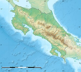
Location within Costa Rica
Location Puntarenas Province, Costa Rica
Nearest city San Isidro de El General
Coordinates 9°09′21″N83°45′17″W / 9.155872°N 83.754732°W / 9.155872; -83.754732
Area5,160 ha (12,800 acres) marine
171 ha (420 acres) terrestrial.
Established9 June 1992
Governing bodyNational System of Conservation Areas (SINAC)
www.sinac.go.cr/ES/ac/acosa/pnmb/Paginas/default.aspx
Costa Rica relief location map.jpg
Red pog.svg
Location in Costa Rica

Ballena Marine National Park (Spanish : Parque Nacional Marino Ballena), is a national park of Costa Rica, part of the Osa Conservation Area created as a safe area for humpback whale migration, hence its name, as Ballena is the Spanish word for whale.

The national park has an area of 5,160 ha (12,800 acres) marine, and 171 ha (420 acres) terrestrial. The park was created by executive decree Nº 21294-MIRENEM on 9 June 1992. [1]

From December to April, the park is visited by migrating humpback whales who come to breed in the warmer tropical waters off the Central American coast. From June to November, the whales migrate north to the West Coast of the United States and southern British Columbia, where they feed. [2]

In the terrestrial area of the park are the Ballena beach, Uvita bay beach and Piñuela beach.

Related Research Articles

<span class="mw-page-title-main">Whale watching</span> Viewing cetaceans in their habitats

Whale watching is the practice of observing whales and dolphins (cetaceans) in their natural habitat. Whale watching is mostly a recreational activity, but it can also serve scientific and/or educational purposes. A study prepared for International Fund for Animal Welfare in 2009 estimated that 13 million people went whale watching globally in 2008. Whale watching generates $2.1 billion per annum in tourism revenue worldwide, employing around 13,000 workers. The size and rapid growth of the industry has led to complex and continuing debates with the whaling industry about the best use of whales as a natural resource.

<span class="mw-page-title-main">Southern right whale</span> Species of whale

The southern right whale is a baleen whale, one of three species classified as right whales belonging to the genus Eubalaena. Southern right whales inhabit oceans south of the Equator, between the latitudes of 20° and 60° south. In 2009 the global population was estimated to be approximately 13,600.

<span class="mw-page-title-main">Manuel Antonio National Park</span> National park in Costa Rica

Manuel Antonio National Park is a small national park in the Central Pacific Conservation Area located on the Pacific coast of Costa Rica, just south of the city of Quepos, Puntarenas, and 157 km (98 mi) from the national capital of San José. It was established in 1972, when the local community sought conservation to prohibit development and destruction of the natural environment. They also protested the beach restrictions on locals by foreign owners. The park has a land area of 1,983 ha and 25,634 ha of water area for a total of 27,587 ha. Despite being one of the smaller Costa Rican parks in land area, Manuel Antonio is the most popular of the 30 national parks in Costa Rica, visited by 4,388,460 people from 2012 to 2022.

<span class="mw-page-title-main">Rías Baixas</span> Series of estuarine inlets in Galicia, Spain

The Rías Baixas are a series of four estuarine inlets located on the southwestern coast of Galicia, Spain. They are the Ría de Muros e Noia, the Ría de Arousa, the Ría de Pontevedra, and the Ría de Vigo. The northernmost Rías Baixas begin below Cape Finisterre while the southernmost rias border the Portuguese coast, taking up the southern part of the Province of Coruña and the entire Province of Pontevedra. Its capital is the city of Pontevedra. Due to unique conditions, the Rías Baixas are rich in marine life which helps the fishing and aquaculture industry of the area. Beaches, marinas, distinctive towns, and plenty of water activities also attract tourists, providing another source of income.

<span class="mw-page-title-main">Abrolhos Marine National Park</span> Brazilian natural reserve

The Abrolhos Marine National Park is a national park that was established in 1983 covering most of the Abrolhos Archipelago area in the state of Bahia, Brazil.

<span class="mw-page-title-main">Cíes Islands</span> Archipelago off the coast of Pontevedra in Galicia, Spain

The Cíes Islands are an archipelago off the coast of Pontevedra in Galicia, Spain, in the mouth of the Ria de Vigo. They were declared a Nature Reserve in 1980 and are included in the Atlantic Islands of Galicia National Park created in 2002.

<span class="mw-page-title-main">Cahuita National Park</span> Terrestrial and marine national park in Costa Rica

Cahuita National Park is a terrestrial and marine national park in the Caribbean La Amistad Conservation Area of Costa Rica located on the southern Caribbean coast in Limón Province, connected to the town of Cahuita. It protects beaches and lowlands and attracts tourists and other visitors who are able to snorkel in the protected marine area which contains the coralline reefs, as well as being a nesting ground for sea turtles. It covers a land area of 2,732 acres (1,106 ha), and a marine area of 55,200 acres (22,300 ha). February through April typically have the best underwater visibility. This is also one of the nicest and least developed beaches in Costa Rica.

<span class="mw-page-title-main">Mochima National Park</span> Protected area in Venezuela

Mochima National Park is located in the States of Anzoátegui and Sucre, on the northeastern coast of Venezuela. The park covers 94,935 hectares and is made up of an exclusively marine area in its western sector, a coastal marine area that includes the Gulf of Santa Fé and Mochima Bay, and a mountainous area that covers the Turimiquire Dam watershed. Mochima Park was created to protect the montane forests of the Turimiquire Range and the country's eastern Caribbean Sea marine landscapes.

<span class="mw-page-title-main">Chiloé National Park</span> National park in Chiloé Island, Los Lagos Region, Chile

Chiloé National Park is a national park of Chile, located in the western coast of Chiloé Island, in Los Lagos Region. It encompasses an area of 430.57 km2 (166 sq mi) divided into two main sectors: the smallest, called Chepu, is in the commune of Ancud, whereas the rest, called Anay, is in the communes of Dalcahue, Castro and Chonchi. The greater portion of the Park is in the foothills of Chilean Coastal Range, known as the Cordillera del Piuchén. It includes zones of dunes, Valdivian temperate rain forests, swamps, and peat bogs. A small portion, Metalqui, is an islet with an area of 0.5 km2 (0.19 sq mi). It is located between 42° 07' and 42° 13' south latitude and between 73° 55' and 74° 09' west longitude.

<span class="mw-page-title-main">Osa (canton)</span> Canton in Puntarenas province, Costa Rica

Osa is a canton in the Puntarenas province of Costa Rica. The head city is in Puerto Cortés district.

<span class="mw-page-title-main">Atlantic Islands of Galicia National Park</span> National park in Galicia, Spain

The Atlantic Islands of Galicia National Park is the only national park located in the province of Pontevedra, in the autonomous community of Galicia, Spain. It comprises the archipelagos of Cíes, Ons, Sálvora and Cortegada. The park covers a land area of 1,200 ha and a sea area of 7,200 ha. It is the tenth most visited national park in Spain. It was the thirteenth national park to be established in Spain. Since 2021 it has been designated as a protected Ramsar site.

<span class="mw-page-title-main">Islas Marietas National Park</span> Group of small uninhabited islands in Mexico

The Marieta Islands are a group of small uninhabited islands a few miles off the coast of the state of Nayarit, Mexico, located in federal waters approximately 7.9 kilometres (4.9 mi) southwest of the peninsula known as Punta de Mita, in the municipality of Bahía de Banderas.

<span class="mw-page-title-main">Pingüino de Humboldt National Reserve</span>

Pingüino de Humboldt National Reserve is a nature reserve located a short distance off the coast of mainland Chile. It consists of three islands: Chañaral, Damas, and Choros. It is located about 100 km (62 mi) north of La Serena in the Coquimbo Region of Chile and has a total area of 859.3 hectares. Coastal communities of Caleta Chañaral, Chañaral de Aceituno, and Punta de Choros are nearby. The reserve is an important breeding site for the Humboldt penguin, for which it is named, and is a habitat for sea lions and bottlenose dolphins, chungungos, sea turtle, whale, albatross and cormorant. Aside from dolphins, local cetacean diversity includes migratory rorquals such as blue, fin, and humpback whales, and sperm whales.

<span class="mw-page-title-main">Bahía Portete – Kaurrele National Natural Park</span> National park in Colombia

Bahía Portete – Kaurrele National Natural Park is a national natural park in Uribia, La Guajira, Colombia. The northernmost national park of mainland South America is located at the Caribbean coast of the La Guajira peninsula in Bahía Portete, between Cabo de la Vela and Punta Gallinas. Established on December 20, 2014, it is the most recently designated national park of the country. As of 2017, 59 nationally defined protected areas are incorporated in Colombia. The park hosts a high number of marine and terrestrial species.

<span class="mw-page-title-main">San Lorenzo Marine Archipelago National Park</span> National marine park in Baja California, Mexico

San Lorenzo Marine Archipelago National Park is a national park of Mexico located on San Lorenzo Island part of an archipelago in the Gulf of California off the eastern coast of Baja California. The San Lorenzo Archipelago is considered one of the most important ecological areas of the Gulf of California. The Island and surrounding areas are part of a rich ecosystem comprised by a grand variety of flora and marine fauna. This area is protected by the Mexican federal government Norma Oficial Mexicana NOM-059-SEMARNAT-2001 because of its importance as a habitat for several endangered species. The Archipelago is part of the municipality of Mexicali, Baja California. The island is located southeast of the city separated by the Salsipuedes Channel.

<span class="mw-page-title-main">Cabrera Archipelago Maritime-Terrestrial National Park</span> National park in the Balearic Islands, Spain

The Cabrera Archipelago Maritime-Terrestrial National Park is a national park that includes the whole of the Cabrera Archipelago in the Balearic Islands, an autonomous community that is part of Spain. The park is the largest in Spain, covering 908 square kilometres (351 sq mi) including 895 square kilometres (346 sq mi) of sea area. The park attracts relatively few visitors due to its remoteness. There is no permanent population, but there might be at any given time just under 100 National Park staff members and other personnel on the islands.

<span class="mw-page-title-main">Uramba Bahía Málaga National Natural Park</span>

Uramba Bahía Málaga National Natural Park, is one of the newest Colombian national parks and a popular ecotourism destination. It is located in and around Málaga Bay on the Colombian Pacific coast in the municipality of Buenaventura, Valle del Cauca, Colombia. It is an area of high biodiversity and a favorite spot for reproducing humpback whales, making this area a popular whale watching destination. Most of natural area is pristine with the exception of the areas around a few small towns like Juanchaco, Ladrilleros, and La Barra, as well as a Colombian naval base. The national park was created in 2010 and is Colombia's 56th national natural park.

<span class="mw-page-title-main">Uvita (Costa Rica)</span> Beach town in southern Costa Rica

Uvita de Osa is a small town in southern Costa Rica, on a section of coastline known as the Bahía Ballena. It is notable for hosting the annual music event and being home to the Cola de Ballena beach which is one of the beaches comprising Marino Ballena National Park. The Whale's Tail has been described as one of the world's most beautiful beaches. Uvita is a good place to see humpback whales in the wild, as there are groups which come from Northern California and Alaska during one time of the year and groups that come from the south and Antarctica during another time of the year. Uvita has grown tremendously since the early 2000s and is the commercial center of the Costa Ballena region. Many expatriates from North America and Europe have made Uvita their home, so many of the locals speak English as well as Spanish.

Caleta Zorra is an enclosed, half-moon shaped inlet on the Pacific coast of Chiloé Island in Los Lagos region, southern Chile. Lying north of Punta Pabellion, it is located among Punta Zorra and Punta Barranco. The nearest residential area is the township of Puerto Carmen.

<span class="mw-page-title-main">Utría National Natural Park</span> Colombian national park

The Utría National Natural Park is a national park in the Chocó Department, Colombia. It contains diverse flora and fauna in a lush, mountainous rainforest environment with some of the highest rainfall in the world, at up to 10,000 millimetres (390 in) annually. The park also protects the coastal marine environment, and is known for visits by humpback whales, who give birth in the lagoon after which the park is named, and sea turtles who nest on the beaches. There is accommodation for visitors, and ecotourism services are provided by the local indigenous people and members of the coastal Afro-Colombian communities.

References

  1. "Parque Nacional Marino Ballena". SINAC. Retrieved 26 September 2019.
  2. "NOAA Fisheries page on Humpback Whales". NOAA. Retrieved 8 July 2020.