This is a list of rivers in Cambodia .


This is a list of rivers in Cambodia .
This list is arranged by drainage basin, with respective tributaries indented under each larger stream's name.
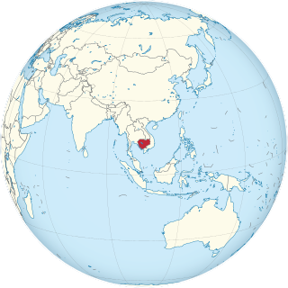
Cambodia is a country in mainland Southeast Asia, border Thailand, Laos, Vietnam, the Gulf of Thailand and covers a total area of 181,035 km2 (69,898 sq mi). The country is situated in its entirety inside the tropical Indomalayan realm and the Indochina Time zone (ICT).

The system of Transport in Cambodia, rudimentary at the best of times, was severely damaged in the chaos that engulfed the nation in the latter half of the 20th century. The country's weak transport infrastructure hindered emergency relief efforts, exacerbating the logistical issues of procurement of supplies in general and their distribution. Cambodia received Soviet technical assistance and equipment to support the maintenance of the transportation network.
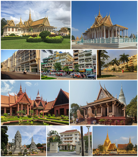
Phnom Penh is the capital and most populous city of Cambodia. It has been the national capital since the French protectorate of Cambodia, and has grown to become the nation's economic, industrial, and cultural centre.

The Mekong or Mekong River is a trans-boundary river in East Asia and Southeast Asia. It is the world's twelfth longest river and the third longest in Asia. Its estimated length is 4,909 km (3,050 mi), and it drains an area of 795,000 km2 (307,000 sq mi), discharging 475 km3 (114 cu mi) of water annually. From the Tibetan Plateau the river runs through China, Myanmar, Laos, Thailand, Cambodia, and Vietnam. The extreme seasonal variations in flow and the presence of rapids and waterfalls in the Mekong make navigation difficult. Even so, the river is a major trade route between western China and Southeast Asia.

The French protectorate of Cambodia refers to the Kingdom of Cambodia when it was a French protectorate within French Indochina, a collection of Southeast Asian protectorates within the French Colonial Empire. The protectorate was established in 1863 when the Cambodian King Norodom requested the establishment of a French protectorate over his country, meanwhile Siam renounced suzerainty over Cambodia and officially recognised the French protectorate on Cambodia.
Articles related to Cambodia and Cambodian culture include:
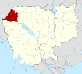
Banteay Meanchey is a province of Cambodia located in the far northwest. It borders the provinces of Oddar Meanchey to the north, Siem Reap to the east, Battambang to the south, and shares an international border with Thailand to the west. Its capital and largest city is Serei Saophoan.

Cambodia is divided into 25 provinces. The capital Phnom Penh is not a province but an "autonomous municipality", equivalent to a province governmentally and administered at the same level as the other 24 provinces.

The Khmer National Armed Forces were the official armed defense forces of the Khmer Republic, a short-lived state that existed from 1970 to 1975, known today as Cambodia. The FANK was the successor of the Royal Khmer Armed Forces (FARK) which had been responsible for the defense of the previous Kingdom of Cambodia since its independence in 1953 from France.
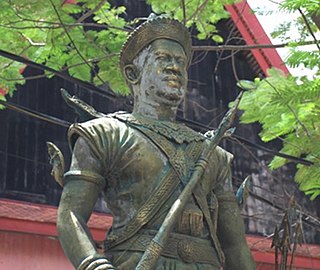
Sdach Korn, also known as Srei Chettha II or Srei Chetha Thireach Reameathiptei, was the King of Cambodia from 1512 to 1525. Korn dethroned the king and attempted to establish a new dynasty. Though little is known about his life as evidence from the 15th and 16th centuries in Cambodia is sparse, Sdach Korn remains a controversial figure in Cambodian history. While he can be considered as a brave soldier who overthrew a cruel king, he can also been seen merely as one of the three usurpers of the throne of Cambodia.

Preah Netr Preah is a district (srok) in the east of Banteay Meanchey province, in north-western Cambodia. The district capital is Preah Netr Preah town located around 24 kilometres due east of the provincial capital of Sisophon by road. Preah Netr Preah district is one of the easternmost districts of Banteay Meanchey. The district shares a border with both Siem Reap province and Battambang province to the east and the south respectively. Two major watercourses, the Sangke River and the Mongkol Borei River run through the district.

Serei Saophoan is a municipality in the centre of Banteay Meanchey province, in north-western Cambodia. Serei Saophoan is the urban district of Banteay Meanchey province and the district capital is also the provincial capital Sisophon town. The town is located 359 kilometres north of Phnom Penh and 48 kilometres from the border with Thailand at Poipet. Serei Saophoan municipality is the central municipality of Banteay Meanchey and is surrounded by other Banteay Meanchey districts. Cambodia's main railway line from Phnom Penh to Poipet enters the municipality from the south and exits to the west.

The 1841–1845 Siamese–Vietnamese War in Cambodia was a military conflict between the Đại Nam, ruled by Emperor Thiệu Trị, and the Kingdom of Siam, under the rule of Chakkri King Nangklao. The rivalry between Vietnam and Siam over the control of the Cambodian heartlands in the Lower Mekong basin had intensified after Siam had attempted to conquer Cambodia during the previous Siamese–Vietnamese War (1831–1834). Vietnamese Emperor Minh Mạng installed Princess Ang Mey to rule Cambodia as a puppet queen regnant of his choice in 1834 and declared full suzerainty over Cambodia, which he demoted to Vietnam's 32nd province, the Western Commandery. In 1841, Siam seized the opportunity of discontent to aid the Khmer revolt against Vietnamese rule. King Rama III sent an army to enforce Prince Ang Duong's installation as King of Cambodia. After four years of attrition warfare, both parties agreed to compromise and placed Cambodia under joint rule.

Cambodia has 612 km (380 mi) of 1,000 mm metre gauge rail network, consisting of two lines: one from the capital Phnom Penh to Sihanoukville, and another from Phnom Penh to Poipet on the Thai border. The lines were originally constructed during the time when the country was part of French Indochina, but due to neglect and damage from civil war during the latter half of the 20th century, the railways were in a dilapidated state and all services had been suspended by 2009. Through rehabilitation efforts by the Government of Cambodia, with funding from the Asian Development Bank, Australian Agency for International Development (AusAID) and Australian company Toll Holdings, freight and limited passenger service returned between Phnom Penh and Sihanoukville by 2016, and passenger service between Phnom Penh and Poipet was fully restored in 2019.

The COVID-19 pandemic in Cambodia is part of the ongoing worldwide pandemic of coronavirus disease 2019 caused by severe acute respiratory syndrome coronavirus 2. The first imported case in Cambodia was detected in Sihanoukville on 27 January 2020. Although a number of imported cases and transmission to direct contacts were confirmed throughout 2020, no community transmission was detected until 29 November 2020. As of July 2021, Phnom Penh has been the most affected province with the majority of infections and deaths. Banteay Meanchey has the second-highest number of infections, whereas Kandal has second-highest number of deaths.
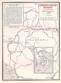
The Cambodia–Thailand border is the international border between Cambodia and Thailand. The border is 817 km (508 mi) in length and runs from the tripoint with Laos in the north-east to the Gulf of Thailand in the south.
| History |  | ||||
|---|---|---|---|---|---|
| Geography | |||||
| Politics | |||||
| Economy | |||||
| Society |
| ||||