
Jurong is a geographical region located at the south-westernmost point of the West Region of Singapore. Although mostly vaguely defined, the region's extent roughly covers the planning areas of Jurong East, Jurong West, Boon Lay, and Pioneer, along with Jurong Island in the Western Islands cluster and the southernmost portions of the Western Water Catchment. Should it be described at its greatest historical extent, the region can also include present-day Bukit Batok and Tuas as well. Jurong also covers several offshore islands as well, including Pulau Damar Laut and Pulau Samulun, both of which are located within the planning areas of Jurong East and Boon Lay respectively; along with the aforementioned Jurong Island. The coastline of the region on mainland Singapore, faces the strait of Selat Jurong, while the southernmost island of the region, Jurong Island, faces the strait of Selat Pandan.

The Malaysia–Singapore Second Link is a bridge connecting Singapore and Johor, Malaysia. In Singapore, it is officially known as the Tuas Second Link. The bridge was built to reduce the traffic congestion at the Johor–Singapore Causeway, and was opened to traffic on 2 January 1998. It was officially opened by Singapore's then Prime Minister Goh Chok Tong with his counterpart, Dr Mahathir Mohamed, who was then Prime Minister of Malaysia. The bridge supports a dual-three lane carriageway linking Kampong Ladang at Tanjung Kupang, Johor to Jalan Ahmad Ibrahim at Tuas, Singapore. The total length of the bridge over water is 1,920 metres (6,300 ft).
Keppel Harbour, also called the Keppel Channel, is a stretch of water in Singapore between the mainland and the southern islands of Pulau Brani and Sentosa. Its naturally sheltered and deep waters was to meet the requirements of British colonists attempting to establish a Far East maritime colony in that part of the world, and thereby setting the stage for the eventual formation of Singapore as a successful independent state.

The Port of Singapore refers to the collective facilities and terminals that conduct maritime trade, and which handle Singapore's harbours and shipping. It is ranked as the top maritime capital of the world, since 2015. Currently the world's second-busiest port in terms of total shipping tonnage, it also trans-ships a fifth of the world's shipping containers, half of the world's annual supply of crude oil, and is the world's busiest transshipment port. It was also the busiest port in terms of total cargo tonnage handled until 2005, when it was surpassed by the Port of Shanghai. Thousands of ships drop anchor in the harbour, connecting the port to over 600 other ports in 123 countries and spread over six continents.

Tuas is a planning area located within the West Region of Singapore. It is bounded by the Western Water Catchment to its north, Pioneer to its east and the Straits of Johor to its west. Tuas also shares a maritime boundary with the Western Islands planning area to its east.

Pulau Brani is an island located off the southern coast of Singapore, near Keppel Harbour. The island is situated between the main island of Singapore and the resort island of Sentosa, and is linked to the mainland via Brani Terminal Avenue. The area of Pulau Brani is 1.22 square kilometres.
Keppel Corporation is a Singaporean conglomerate headquartered in Keppel Bay Tower, HarbourFront. The company consists of several affiliated businesses that specialises in offshore & marine, property, infrastructure and asset management businesses.
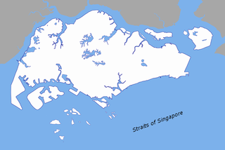
The Singapore Strait is a 105-kilometer long, 16-kilometer wide strait between the Strait of Malacca in the west and the Karimata Strait in the east. Singapore is on the north of the channel and the Riau Islands are on the south. The Indonesia-Singapore border lies along the length of the strait.

The Ayer Rajah Expressway extends from the western end of the Marina Coastal Expressway in the south of Singapore to Tuas in the west near the Tuas Second Link to Malaysia. Together with the Marina Coastal Expressway and the East Coast Parkway, it forms a second east-west link to complement the role played by the Pan Island Expressway.

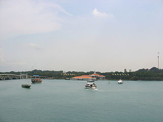
Jurong East is a planning area and residential town located in the West Region of Singapore. It borders Jurong West and Boon Lay to the west, Clementi to the east, Tengah and Bukit Batok to the north and Selat Jurong to the south.
Rail transport in Singapore mainly consists of a passenger urban rail transit system spanning the entire city-state: a rapid transit system collectively known as the Mass Rapid Transit (MRT) system operated by the two biggest public transport operators SMRT Trains and SBS Transit, as well as several Light Rail Transit (LRT) lines also operated by both companies. In addition, local specialised light rail lines are in operation in places such as the Singapore Changi Airport and Sentosa.

The West Region of Singapore is one of the five regions in the city-state. The region is the largest in terms of land area and is the second most populous region after the Central Region. Jurong East is the regional centre of the region, with plans of developing the Jurong Lake District into a second CBD area. Jurong West is the most populous town in the region, with a population of 272,660 residents. Comprising 25,500 hectares of land area, it includes twelve planning areas and is home to about 903,010 residents.

The Malaysia–Singapore border is an international maritime border between the Southeast Asian countries of Malaysia, which lies to the north of the border, and Singapore to the south. The boundary is formed by straight lines between maritime geographical coordinates running along or near the deepest channel of the Straits of Johor.

West Coast Group Representation Constituency is a four-member Group Representation Constituency located in the western area of Singapore. The GRC is divided into four divisions and is a constituency held by the People's Action Party. The four divisions are Ayer Rajah, West Coast, Boon Lay, and Telok Blangah. West Coast GRC covers the areas of Ayer Rajah, Dover, Pasir Panjang, the south-western area, West Coast, Jurong, Jurong Island, Sentosa, Telok Blangah, Tuas and much of Singapore's southern & western territorial waters of the country.
The Western Islands is a planning area located within the West Region of Singapore. It comprises a collection of islands located in the south-western waters of Singapore, namely Jurong, Bukum and Sudong Islands.
Pioneer Sector is part of the Jurong Industrial Estate which is the largest industrial estate in Singapore.
Pioneer is a planning area located in the West Region of Singapore, named after Pioneer Road. The area is bounded by Jurong West to the north, Boon Lay to the east, Tuas to the west, the Western Water Catchment to the northwest and Selat Jurong to the south, and contains the Joo Koon, Benoi and Gul Circle industrial estates.


